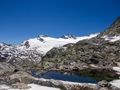
A grand tour around the Mattmark artificial lake starting at the Mattmark dam for an amazing trip to high alpine territory with amazing views, pure nature in it's best.
Some notes before we start the guide:
The first part of the track is a hidden trail well known by local people and is not marked on a tourist map so it is a peaceful hike trough rough territory with bits of pathless tracks, snowfields, fairly easy rock sections, ... It is marked as an alpine (white blue white) trail and is only for experienced hikers! Hiking classification is a T3 challenging mountain hike.
This first part of the track (Ze Seewjine) is maintained by the Saaser hiking club and it is not maintained at a high frequency, that is why it is marked as an alpine trail and not marked on the tourist hiking maps and the official topo map of Switzerland because they can't guarantee that the whole track is without obstacles. Inform yourself at a hotel or tourist office what the conditions are (if known).
Summary:
- T3 - Challenging Mountain hike
- Elevation up and down: 955m
- Duration: 6h
- Snowfields can block parts of the route
Let's go hike!
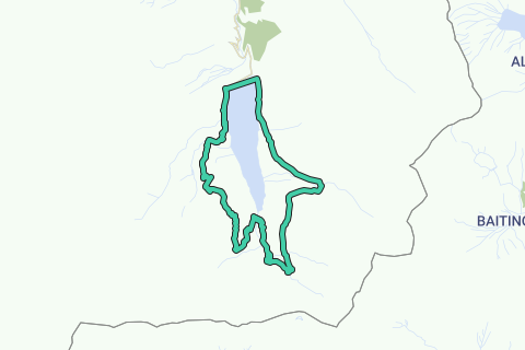
The route starts at Europe's biggest dam made out of rubble and dirt of the Allalin glacier. We go along the big road along the lake to the right side and go through a tunnel. A bit further ahead we turn right, a big road leading upwards to the Schwarzbergalp in the direction of Schwarzberg/Mattmark Glacier trail. Where the road makes an almost U-turn, you'll see a trail straight ahead with the direction Ze Seewjine / Distelalp. Now comes to most tricky part of the whole route, look carefully for the white-blue-white paint on the rocks, they will lead you to the three sees (Ze Seewjine) and further to the Distelalp. You'll notice on your GPS that this path isn't on the map for the first part. Enjoy the magnificent views along the road, it's really breathtaking! Watch out for debris fields, snow fields and snow slopes, sometimes with no trail through the snow (very few people come here). Once you stopped climbing, you'll get to see the small mountain lakes inside a small inner valley with amazing view on the Seewjinen glacier. It's a great picnic place as well in the middle of pure untouched nature where you can also meet some Alpine Ibex. The return to the lake is a bit more tricky again, at first you walk along a ridge downwards and then the path gets more wild with amazing alpine flowers, distels (it's the distelalp for something...), high grasses and a steep downhill along an overgrown path. Once down you'll arrive at a small animal hut with cows grazing around, because of the electrified fence it can be that you'll have to find a way through the field before getting on the big road along the lake again. If you're too tired after this trip, you can get back to the dam along the big road, but for the die hards we go to the right in the direction of the Monte Moro pass and at the end of the lake we go further in that direction along a T2 trail leading up to the famous Monte Moro trail. We won't go to the mountain pass, it is optional, but the hike is already tough enough if you want to make it back to the dam at the end of the day. Where the road splits itself just below 2500m, we take the path to the left in the direction of Ofental. With some rocky sections this high trail is fairly easy and leads us into the Ofentall, a small side valley of the Mattmark area with also some interesting hikes. Along this path you'll get nice views over the other side of the lake where we did the first part of the trail and of course at the lake itself. The road turns to the right right inside the Ofental valley, at the intersection we turn left back to Mattmark Stausee along an easy trail that leads to the big road along the lake. Once arrived their it's only 1,5km left to get back to the starting point.
Navigate route in...
![]() RouteYou app Open
RouteYou app Open
Don't want to see this ad anymore?
→ Upgrade now
![]()
Please wait, the navigation is being prepared.
You can now navigate. Have fun on the road!
Processing your request has failed. Please try again.
Don't want to see this ad anymore?
→ Upgrade now
![]()
Please wait, your download is being prepared.
Your download is ready. Have fun on the road!
Processing your request has failed. Please try again.
Don't want to see this ad anymore?
→ Upgrade now
![]()
Please wait, your print is being prepared.
Your print is ready to download. Have fun on the road!
Processing your request has failed. Please try again.
Don't want to see this ad anymore?
→ Upgrade now
![]()
Please wait, your download is being prepared.
Your download is ready. Have fun on the road!
Processing your request has failed. Please try again.
<iframe src="https://plugin.routeyou.com/routeviewer/free/?language=en&params.route.id=4515695" width="100%" height="600" frameborder="0" allowfullscreen></iframe>
<a href="https://www.routeyou.com/en-ch/route/view/4515695/hiking-route/mattmark-high-alpine-trail-ze-seewjine-talliboden-ofental?utm_source=embed&utm_medium=article&utm_campaign=routeshare" title="Mattmark High Alpine trail: Ze Seewjine - Tälliboden - Ofental - RouteYou" target="_blank"><img src="https://image.routeyou.com/embed/route/960x670/4515695-en@2x.png" width="960" height="670" alt="Mattmark High Alpine trail: Ze Seewjine - Tälliboden - Ofental"></a>
Additional feedback:
Try this feature for free with a RouteYou Plus trial subscription.
If you already have such an account, then log in now.
Try this feature for free with a RouteYou Premium trial subscription.
© 2006-2024 RouteYou - www.routeyou.com