889 views | Public | French
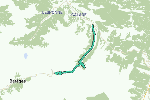
Climb to the Col du Tourmalet from Sainte Marie de Campan. The climb has a length of 17.2km, a height difference of 1268m. You will reich a height of 2115m. The maximum slopis is 13% at km 15 and 16.5.
Navigate route in...
![]() RouteYou app
Open >
RouteYou app
Open >
![]()
Please wait, your print is being prepared.
Your print is ready to download. Have fun on the road!
Processing your request has failed. Please try again.
![]()
Please wait, your download is being prepared.
Your download is ready. Have fun on the road!
Processing your request has failed. Please try again.
<iframe src="https://plugin.routeyou.com/routeviewer/free/?language=en&params.route.id=1371443" width="100%" height="600" frameborder="0" allowfullscreen></iframe>
<a href="https://www.routeyou.com/en-fr/route/view/1371443/road-bike-route/climb-to-the-col-du-tourmalet-from-sainte-marie-de-campan?utm_source=embed&utm_medium=article&utm_campaign=routeshare" title="Climb to the Col du Tourmalet from Sainte Marie de Campan - RouteYou" target="_blank"><img src="https://image.routeyou.com/embed/route/960x670/1371443-en@2x.png" width="960" height="670" alt="Climb to the Col du Tourmalet from Sainte Marie de Campan"></a>
Additional feedback:
Try this feature for free with a RouteYou Plus trial subscription.
If you already have such an account, then log in now.
Try this feature for free with a RouteYou Premium trial subscription.
© 2006-2024 RouteYou - www.routeyou.com