173 views | Public
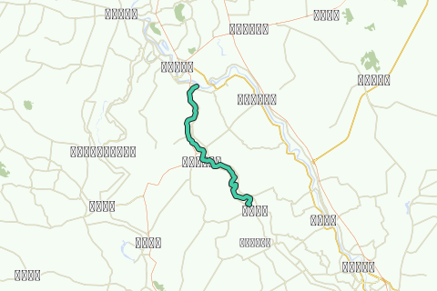
This kayak track is the first kayak track of the Chao Phraya Noi River descent and part of the Chao Phraya Noi River Kayak Project set up by Ayutthaya kayaking Experience [AKE] aiming to paddle the full stretch of this river from north of the Chaya Phraya Dam in Chainat district until its confluence with the Chao Phraya River at Bang Sai (Thailand).
The Maenam Noi or Chao Phraya Noi (or small Chao Phraya) is one of the three tributaries of the Chao Phraya. The latter is formed by the confluence of four rivers at Nakhon Sawan being the Ping, the Nan, the Wang and the Yom. The Chao Phraya gives birth to three children of its own: the Tha Chin or Suphan River, the Noi River and further downstream the Lopburi River; starting in fact a delta at Chainat. The Noi River branches off from the Chao Phraya River about 5 Km south of Chai Nat. It is one of the former courses of the Chao Phraya itself.
The Chao Phraya initially flowed west of its present course beginning just below Chai Nat and running to Ang Thong via Sankha Buri, Bang Rachan and Pho Thong. The river must then have breached its west bank near Ang Thong because in its route it ran south-west from Intha Pramun via Wiset Chai Chan, Phak Hai, and Sena, and entered its present-day channel at Bang Sai. After some time, the river bed of the Chao Phraya over Sankha Buri appears to have silted up and the river shifted to the east. The Chao Phraya broke its east bank near Chainat, flowing nearly north-east for 12 kilometers before turning south, approximating the Chao Phraya’s present course from Chainat to Ang Thong. In 1857 the Chao Phraya River took a new course from Ang Thong to Ayutthaya, due to man-made channel works. The old river bed from Chainat over Ang Thong and Sena to Bang Sai became as thus known as the Chao Phraya Noi. The latter re-enters the Maenam at Wat Bang Sai.
This track brings you from Chai Nat to Pho Ngam and goes through a part of Muang Chai Nat and Sankha Buri district of Chai Nat Province. Sankha Buri, locally known as San Buri was an important historical city in earlier times. The Sankha Buri district is divided into eight sub-districts or "tambon". The Noi River runs on this track along the borders of Phraek Sri Racha and Thiang Thae sub-districts as well as Bang Khut and Pho Ngam sub-district. Starting from Chai Nat there are a lot of fish farms along this track of the Noi River. The fish mainly farmed on this waterway is the red tilapia known in Thailand as "Phla Tap Thim, scientific name "Oreochromis niloticus". The Tilapia is very common in the Thai cuisine and a type of fish popular for fish farming worldwide.
The tour will take 6-7 hours of paddling according to your level of physical fitness, the conditions of the water current, and your personal kayaking experience. Highlights are listed to give you a number of reference points on this tour itinerary. Do not initiate this tour without the necessary physical fitness and preparation.
Tips and Warnings
General - Stock up supplies of water (500 ml/hr), electrolyte beverages (3-4 bottles) and dry food (take a snack every 2 hours) as there is hardly opportunity to find a meal on this itinerary. Keep up mobile communications with somebody for emergency cases and do know where you are exactly at all times. Protect your equipment with waterproof bags and tie everything to the boat.
Water currents - The most important variable for making kayaking plans is water current. Rainy season will result in flooding and/or rapidly moving water. In this case not every kayak is suitable. For this track in the rainy season you will need a kayak suitable for wild water. This track is notorious for whirlpools during the rainy season. Use caution when the current is fast and wear a life jacket.
Clothing - Wear a good hat and loose-fitting clothing that dries quickly. Long pants and shirts with long sleeves may be useful and appropriate to protect you from the sun. The refracted sunlight from the water makes sunburn commonplace, so put on plenty of sun block on not covered parts of your body and wear sunglasses.
Who are we?
Ayutthaya Kayaking Experience [AKE] is a sportive subsidiary from Ayutthaya Historical Research [AHR]. AKE’s objective is to promote kayaking tourism in Ayutthaya, by basically showing kayak presence on canals and rivers. Kayaking is the perfect outdoor recreation to explore the city island contours and its surroundings. We are local expatriates who have been living in Ayutthaya for many years and would like to share our kayak knowledge with other sportsmen. More information on AKE can be found at: http://aykaex.yolasite.com/
Disclaimer
Ayutthaya Historical Research or Ayutthaya Kayaking Experience will not be held liable for any loss or damage whatsoever for any suggestions made in relation to the site’s promotion of ecotourism. It is the responsibility of the user of the site to take the necessary precautions to avoid any physical injury, traffic incident, animal attack, theft, and damage to equipment. Any reliance on the site’s information is therefore strictly at your own risk. Read our full disclaimer at website www.ayutthaya-history.com.
©2010-2011 Ayutthaya Kayaking Experience
All rights reserved.
Navigate route in...
![]() RouteYou app Open
RouteYou app Open
Don't want to see this ad anymore?
→ Upgrade now
![]()
Please wait, the navigation is being prepared.
You can now navigate. Have fun on the road!
Processing your request has failed. Please try again.
Don't want to see this ad anymore?
→ Upgrade now
![]()
Please wait, your download is being prepared.
Your download is ready. Have fun on the road!
Processing your request has failed. Please try again.
Don't want to see this ad anymore?
→ Upgrade now
![]()
Please wait, your print is being prepared.
Your print is ready to download. Have fun on the road!
Processing your request has failed. Please try again.
Don't want to see this ad anymore?
→ Upgrade now
![]()
Please wait, your download is being prepared.
Your download is ready. Have fun on the road!
Processing your request has failed. Please try again.
<iframe src="https://plugin.routeyou.com/routeviewer/free/?language=en&params.route.id=330097" width="100%" height="600" frameborder="0" allowfullscreen></iframe>
<a href="https://www.routeyou.com/en-th/route/view/330097/canoe-kayak-route/1-chainat-pho-ngam-kayak-track?utm_source=embed&utm_medium=article&utm_campaign=routeshare" title="1. Chainat - Pho Ngam Kayak Track - RouteYou" target="_blank"><img src="https://image.routeyou.com/embed/route/960x670/330097-en@2x.png" width="960" height="670" alt="1. Chainat - Pho Ngam Kayak Track"></a>
Additional feedback:
Try this feature for free with a RouteYou Plus trial subscription.
If you already have such an account, then log in now.
Try this feature for free with a RouteYou Premium trial subscription.
© 2006-2024 RouteYou - www.routeyou.com