2094 views | Public | Dutch
Once past Brussels, the Senne does not flow in the middle of its valley, on its right bank it lies from Brussels to Weerde next to the Barebeek (which belongs to the Dyle valley). There, the Senne is fed only by streams and ditches on its left bank.
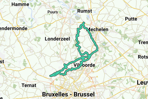
This cycle loop is special because it takes you along the banks of the three natural watercourses that flow into the Senne above Brussels. This results in a loop on the west side of the Senne in the form of a flat 8.
In order to stay as close as possible to a stream, on some strips of field roads or a path are taken. During very wet periods, some of these are filthy. The loop is therefore not designed to cycle everything at 20km/h or faster. It is perfect for the recreational and creative cyclist who likes to do some small parts at 10km/h.
Sights and particularities of this loop:
Beautiful and quiet nature along the Senne, streams and ditches; sand extraction area; five (not four!) watermills along the Maelbeek (the longest of the 3); three springs, two streams of which run siphoned under the Zeekanaal and have an overflow to the Zeekanaal; various (fish) ponds; forests and fields; ...
Bridges are also taken over the Brussels Ring and the A12, which provide special views north of Brussels.
And there is regularly the possibility for a drink, snack and children's fun.
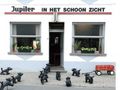
The starting point is at café 't Schoonzicht opposite the village church in Weerde (sufficient parking at the church).
First you cycle via the Galgenberg to the confluence of the Senne and its shortening, after which the towpath on the left bank is cycled past the separated bicycle bridge in Leest.
Three Bekenroute with info:
1. The Aabeek
(stream length 11 km, height difference 8 m; source between Humbeek-Sas and Kattemeuterbos on the east side of the Zeekanaal; mouth in Leest above the bicycle bridge on the Zenne - Molenweg-Molenbeekstraat -).
In Leest this stream is called the Molenbeek. A little further north than its mouth we leave the Senne and follow the first part of the Aabeek on its left bank. Past Leest we follow part of the field roads around the Aanbeek, and end up on the north side of the Bos van Aa. In the 70s, the orchards and fields here were expropriated to collapse the dredged sludge from the newly created Zeesluis in Zemst (Currently this zone is used for sand extraction). Here the Aabeek on the west side, between the sand extraction area and the Canal, has been diverted. South of this sand extraction area we look back up the Aabeek and follow it through Humbeek-Sas and come across its two sources on the north side of the road at the Bergstraat in Grimbergen.
2.De Maelbeek
(stream length 14 km, height difference 52 m; source in Relegem southwest of Wemmel; mouth in a crossed Zennemeander southeast of the Burnt Bridge, above the turning dock).
The mouth of the Maelbeek into the Senne is slightly further south than the source of the Aabeek. We follow the Oostvaartdijk southwards to past the Kattemeuterbos. At the Kerselarendries we take the asphalt road on the left, drive straight on past the high-voltage lines, and then take right to the Mot and cross the Humbeeksesteenweg near Eppegem.
On the T we take left, then right and cross an old Sennearm. This Senne arm runs a little further north together with the Zennever discount, which was made to excavate the turning dock on the right bank of the canal. We follow this Senne arm in a southerly direction (right). We arrive at the rear of the industrial zone Cargovil (Dorent-Nelebroek) and cross a dead end asphalt road to follow the water back. We leave a few houses on the right and after a sharp bend we come across an Aquafin water treatment plant. At this place the Maelbeek flows into the Senne. We follow the water next to the installation and arrive on an industrial road that we take on the right, and after crossing 100m, a traffic-free street to the Burnt Bridge. Over this bridge we first take right, and 50m past the first street on the left the Maelbeek siphons under the Zeekanaal to the Aquafin installation.
We return for a while and take that first street away from the Zeekanaal, after which we take the first right behind the Sports Hall. Here we follow one of the most beautiful places of the Maelbeek valley in Grimbergen, and pass the Oyenbrugmolen (private property, mill not visible from the street), Tommenmolen, Liermolen and past the center and the stone road Vilvoorde-Wolvertem-Aalst (monument dr. Hemerijckx) the 's Gravenmolen (private property). Pit stop at the last three mills possible.
At the 's Gravenmolen we follow the right bank and arrive via Strombeek (Nekkerbos and Potaarde) on the A12 under which the Maalbeek dives. On the other side of the A12 is the Sprietmolen. Just follow the A12 north to take a bicycle bridge, then back south, crossing the Maelbeek (possibly at the bus stop on the left follow the Maalbeek for 50m on its left bank through the grove, so that you can see the Sprietmolen from there (private property. Exterior work of the mill itself in serious disrepair (see POI- ). At the crossroads (Zijp) direction Wemmel, then first left to cross the Maelbeek again and follow them on the right bank until Wemmel (On the right we pass the Castle / Town Hall with castle park).
From here the Maelbeek is called the Landbeek, which we can no longer follow because it flows through the fields. We follow the north flank of the Maelbeek valley (side Grote Landbeek), and a little past the church of Relegem (southeast) we have the farthest and highest source of the Maelbeek at / just above a grove.
When we return from the source we notice the Maalbeek from the transverse Poverstraat under the dead-end Florist Street. At the end of the Bloemistenstraat, the Maalbeek comes back above ground towards Wemmel. A second source (from the Kleine Landbeek) is located a little south along the Poverstraat, opposite the football fields.
6 km back, 1.8 km southeast of the Sprietmolen and within the Great Ring around Brussels is the source of the Tangebeek in Strombeek-Bever.
You can take the south flank of the Maelbeek valley so that if you want to see the Maelbeek again you have to drive up a steep slope twice (Schapenbaan - Smiskensveld --> Malbeek --> Oude Jetseweg - Obberg).
The proposed route keeps us close to the Maelbeek until a safe bridge (Panoramastraat) is taken over the Ring: Return to the church of Relegem, then turn right and then left into the Oude Jetseweg. Just before the right the first street (Kanariestraat, at the Mariakapel) there is a footpath on the left between two horse meadows. We follow this footpath for about a km until it ends in the Mottestraat.
[Two marshy sections, therefore this description: Follow the right Paardeweide -at the end continue to follow the meadow on the right- soggy in the bend), and 10m further the path turns left into the grove. Here the path suddenly rises about 3 meters. Some people put a branch or tree over the path, but you can go further through it. 30m further, at the end of the grove, there is again a marshy place of about 15 meters. Leave the wood obstacles behind, and take the left behind them. The path becomes wider and paved. From the gate the road is paved (Mottestraat).]
Via the slightly quieter Panoramastraat bridge we cross the Ring, and take the Roman road north of the Exhibition Park. Just before the end of the Exhibition Park, turn left (Treftstraat, at Hotel Ibis) and follow it on the A12 (again beautiful views). You arrive at a pentagon in Strombeek-Bever (with newsagent on the corner) where you take the fourth right (Oude Mechelsestraat). There you take the third right (IJsvogellaan) down and on the transverse Grimbergsesteenweg you choose on the right diagonally over the old tram bed to the Haneveld sports fields. On the right is a pond, on the left is the source area of the Tangebeek.
3. The Tangebeek
(stream length 6 km; height difference 28 m; source in the Haneveld in Strombeek-Bever; mouth in Zenne southeast of the Burnt Bridge under the turning dock):
From the pond we follow the Tangebeek; first right bank, then left and then back right bank (old deep meander in the Haneveld). On the busy Sint-Annalaan 20m to the right to be able to cross it safely. Then back on the left, you cross the Tangebeek which runs next to the football field (nice to see the siphoning, then follow the path between the Tangebeek and the Tange Football Field for 100m).
Then cross under the Ring, and immediately after the last exit take the concrete road on the right; Follow the exit along the Akkerweg in parallel. A little further on you can take a narrower path on the right that descends into a grove. 30m further you immediately have on your left a (usually open) sewer cover under which the Tangebeek flows 5 meters deeper. You cross the invisible Tangebeek below you, you can watch the emergence of the Tangebeek on foot on the left of this road. Follow this path until you reach Avenue Albert-II; then left and back left into the Tangebeekbos. You descend it on the left until you come parallel to the Tangebeek. Take left back in the forest to cross the Tangebeek via a bridge. Follow the Tangebeek on its left bank until you have to take a bridge over the Tangebeek 800m further back. Here the flow rate of the Tangebeek is very variable. In rainy weather, the large flows have dug deep gullies, causing the banks to collapse.
Over the second bridge take left, then right into the forest path; you now take the right bank of the Tangebeek, which here is the deepest carved valley along the lower Senne. At the busy Rubensstraat you take the clinker path to the left after 20m back to the Molenveld tunnel which we take on the right.
We arrive in the Borgt, where a chapel on the Tangebeek refers to the many deaths that were to be regretted in various floods. Downstream a large culvert has been made where the Tangebeek runs to the Zeekanaal under a playground and a pond park (we follow the Tangebeek above ground).
Take the recreational area with ponds a little further to the left, but leave it behind. At the end of the park take right, behind the houses in front of you is an old Motte on which the Castle of the Berthouts was located - and where the original center of Grimbergen was located - (http://nl.wikipedia.org/wiki/Senecaberg ).
Take left at the apartment blocks and you will arrive at a water sports quay on the Channel. Here is also an overflow of the Tangebeek into the canal.
Take back immediately left (Verbindingsweg) and then right along a marshland (Domain of Borgt). At the end of this car-free street you will notice the Tangebeek under the street, which dives further under the Humbeeksesteenweg into a business area. Take back there on the right and on the canal on the left.
At the first high-voltage pylon for the turning dock, the Tangebeek runs siphoned under the canal. Over the Burnt Bridge we take the dead end alley on the right and take on the T on the right, over the bridge at the turning dock. In the bend to the right, the Tangebeek comes approximately under the street and flows into it at the bridge over the Senne. Take the Senne on the right to Eppegem. Dive right under the railway line and immediately take the Hauwlandweg to the left until the Zenne and Weerde.
Navigate route in...
![]() RouteYou app Open
RouteYou app Open
Don't want to see this ad anymore?
→ Upgrade now
![]()
Please wait, the navigation is being prepared.
You can now navigate. Have fun on the road!
Processing your request has failed. Please try again.
Don't want to see this ad anymore?
→ Upgrade now
![]()
Please wait, your download is being prepared.
Your download is ready. Have fun on the road!
Processing your request has failed. Please try again.
Don't want to see this ad anymore?
→ Upgrade now
![]()
Please wait, your print is being prepared.
Your print is ready to download. Have fun on the road!
Processing your request has failed. Please try again.
Don't want to see this ad anymore?
→ Upgrade now
![]()
Please wait, your download is being prepared.
Your download is ready. Have fun on the road!
Processing your request has failed. Please try again.
<iframe src="https://plugin.routeyou.com/routeviewer/free/?language=en&params.route.id=451746" width="100%" height="600" frameborder="0" allowfullscreen></iframe>
<a href="https://www.routeyou.com/en-be/route/view/451746/recreational-cycle-route/the-8-of-the-aabeek-maelbeek-tangebeek-and-zenne-departure-weerde-77km?utm_source=embed&utm_medium=article&utm_campaign=routeshare" title="The 8 of the Aabeek, Maelbeek, Tangebeek and Zenne, departure Weerde (77km) - RouteYou" target="_blank"><img src="https://image.routeyou.com/embed/route/960x670/451746-en@2x.png" width="960" height="670" alt="The 8 of the Aabeek, Maelbeek, Tangebeek and Zenne, departure Weerde (77km)"></a>
Additional feedback:
Try this feature for free with a RouteYou Plus trial subscription.
If you already have such an account, then log in now.
Try this feature for free with a RouteYou Premium trial subscription.
© 2006-2024 RouteYou - www.routeyou.com