3290 views | Public | Dutch
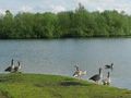
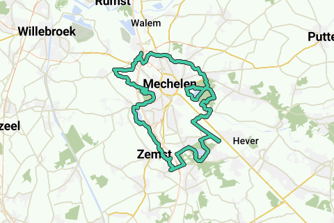
A safe (walking, walking or cycling) loop of 42.2km along the most beautiful nature around Mechelen: The Green Mechelen Marathon.
This unique and traffic-free Green Marathon through Mechelen has been picked up by the editors of 'De Nieuwe Maan' (page 3 at the bottom left of http://www.mechelen.be/_uploads/Diensten/Communicatiebeleid/downloads/NM31_def_22102012_LR_website.pdf )
The departure of the drawn loop is on the north side of the Weerdse visput (spacious parking). You can of course start from any other point on the loop. This loop is 100% in accordance with the registration by my high-quality GPS: A reliable loop for any walker, jogger, marathon runner or cyclist.
Although Mechelen is located on the busy Antwerp-Brussels and Willebroek-Haacht-Leuven traffic axes, all (busy) roads are avoided as much as possible. If a crossing inevitably has to be made, this is done in a safe location.
The vast majority of this 42.2 km long loop is traffic-free and is drawn along the most important natural watercourses in and around Mechelen: the Vrouwvliet/Boeimeerbeek to the north, the Senne and Barebeek to the south, and the Dijle, which occurs centrally twice in the course. The Leuvensevaart is also briefly followed in the southern part of the trail because there is currently no other possibility to go from the Senne valley to the Dijle valley in a green way.
In the vicinity of these natural watercourses, low marshy grazing meadows (trousers or flood plains) have traditionally been present, which we inevitably address:
The Mechels Broek in the northeast, the Robbroek in the northwest, the Vrijbroek in the west, (and a short part the Vriezenbroek in the south).
In these marshy meadows, natural or man-made lakes were created, which today always provide beautiful views and natural beauty. This loop will also let you taste this eagerly:
Eastern: Between the Dijle and the Boeimeerbeek (= the predecessor of the Vrouwvliet to Pasbrug) the small Nekkervijver was created in the Mechels broek.
West: Between the Senne and Dijle, the ponds in the Vrijbroekpark were excavated with the spade around 1930 according to the plan of landscape architect De Bosschere. The excavated soil was used for the elevation of other parts of the Vrijbroek.
(info from the park rangers, http://www.google.be/url?sa=t&rct=j&q=geschiedenis%20van%20het%20vrijbroekpark%20mechelen&source=web&cd=50&ved=0CF0QFjAJOCg&url=http%3A%2F%2Fwww.despreeuw.be%2FDocumenten%2F20010703_RSM_2__informatief_gedeelte.doc&ei=TcLYT7eCDaWr0QXRrOCIBA&usg=AFQjCNExjOw9AMP5qds6HAJPskiCyxctMw&cad=rja
and
http://www.beeldbankmechelen.be/index2.php?option=com_memorix&task=topview&searchplugin=eenvoudig&Itemid=53&mrxpopup=1&CollectionID=1&PhotoID=SME001002137&RecordID=2624&ResultRecord=0 )
South: The construction of the Muizen-Weerde-Brussels railway line (1901-1914) created a large artificial pond in the later Bloso domain Hofstade (after many drownings, it was split in two by a high intermediate verge).
Eastern and western: Due to the construction of the E19 (until 1985 called the E10; built in the late 1960s), the Nekker was further excavated and enlarged, and the artificial Eglegem pond on the Hombeek-Zemst border and the Weerdse fish pit (southern) were excavated. The youth of the time collected mammoth bones and shark teeth during these spraying works.
This loop runs along all these 'waters with their own story' around Mechelen. It passes through the (sub)municipalities of Weerde, Hofstade, Muizen, Bonheiden, Pasbroek, Mechelen, Leest, Hombeek and Zemst.
From Weerde you will come across the following water chronologically:
Weerdse visput;
Senne and Barebeek;
Recreation area Hofstade;
Leuvensevaart;
Dyle;
Mechels Broek and Boeimeerbeek;
The Nekker;
Woman;
Dyle;
Vrijbroekpark;
Eglegem pond;
Senne;
This loop also brings you into contact with some bunkers of the KW line (http://www.kwlinie.be)
In the north of the loop, the Vrouwvliet runs several times under the traffic junction from Mechelen-Noord to the Dijle. In the past, you had to go to the bridge of the Antwerpsesteenweg over the Vrouwvliet this busy stone road:
(1) take a southerly direction to Mechelen (up to the large intersection above the Dijle);
(2) either take the north, cross the intersection with the R6, and then a little further left over a dangerous bridge over the E19 to the industrial zone;
Both slopes were a turn-off for both the walker and runner as well as cyclist.
At the end of October 2012, a green crossing was realized next to the R6. This path is currently cleared, but not yet paved. In any case, this is a wonderful improvement compared to the previous situation where the bush on the R6 had to be climbed by the weeds.
To see this improvement at the junction of the R6/N16/E19 north of Mechelen, it is best to maximize your browser first. Then click on the large button 'Interactive map' in the map. There will then be a large pop-up window with an enlarged/draggable map, and on her right a column with a formatted explanation of this green marathon. This allows you to click on each POI in the zoomed-in part of the green marathon (up to 200 POIs in total): In the right column there will be a photo with an explanation of your selected POI on the map. If you also click on the photo itself in the right column, you will get an additional pop-up window with an enlargement of the clicked photo (Browser maximum for this!).
Finally, two small points of attention for this green marathon around Mechelen:
1.
In the Mechels Broek you have to take off the bike a few times in front of the cow gates (lift the bike over it) or in front of the narrow bridges (sometimes with a step! don't drive against it!) over the water.
In any case, that little effort is really worth it.
2.
North of the Nekker in the Mechels Broek there is an inevitable small overlap in the loop: After you have continued the Broek north in the east, you take the bridge over the Boeimeerbeek where you take the left and follow the stream (next to the dike it is best to do). At the next bridge over the Boeimeerbeek you take left again to follow the Boeimeerbeek for a bit and then southwest past two cow gates to the two large ponds of De Nekker (2m climb). Between the two ponds you continue southwest to the Dijle (beautiful viewpoint), after which you turn right.
After you have completely rounded the northern pond on your right, you go back via the same path past the cow gates (2m descents) to the last bridge over the Boeimeerbeek, and you continue the loop in a northerly direction.
This overlap between the bridge on the Boeimeerbeek and the Nekkervijvers is less than 300m one way.
Have fun with this quiet and wonderfully low-traffic 42.2km in nature!!!
Navigate route in...
![]() RouteYou app
Open >
RouteYou app
Open >
Don't want to see this ad anymore?
→ Upgrade now
![]()
Please wait, the navigation is being prepared.
You can now navigate. Have fun on the road!
Processing your request has failed. Please try again.
Don't want to see this ad anymore?
→ Upgrade now
![]()
Please wait, your download is being prepared.
Your download is ready. Have fun on the road!
Processing your request has failed. Please try again.
Don't want to see this ad anymore?
→ Upgrade now
![]()
Please wait, your print is being prepared.
Your print is ready to download. Have fun on the road!
Processing your request has failed. Please try again.
Don't want to see this ad anymore?
→ Upgrade now
![]()
Please wait, your download is being prepared.
Your download is ready. Have fun on the road!
Processing your request has failed. Please try again.
<iframe src="https://plugin.routeyou.com/routeviewer/free/?language=en&params.route.id=464097" width="100%" height="600" frameborder="0" allowfullscreen></iframe>
<a href="https://www.routeyou.com/en-be/route/view/464097/jogging-route/mechelen-marathon-42-2km?utm_source=embed&utm_medium=article&utm_campaign=routeshare" title="Mechelen Marathon (42,2km) - RouteYou" target="_blank"><img src="https://image.routeyou.com/embed/route/960x670/464097-en@2x.png" width="960" height="670" alt="Mechelen Marathon (42,2km)"></a>
Additional feedback:
Try this feature for free with a RouteYou Plus trial subscription.
If you already have such an account, then log in now.
Try this feature for free with a RouteYou Premium trial subscription.
© 2006-2024 RouteYou - www.routeyou.com