6605 views | Public | Dutch
Directions
Collect and leave Parking at the ferry of Kruibeke. Scheldelei 12, Kruibeke.
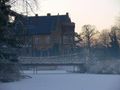
Route course: via the ring dike (dike between the flood zone and Kruibeke village) 2 km towards Basel until the intersection (Kemphoekstraat) where cars can cross the dike. Follow the first right road down, cross the Barbierbeek via the bridge and continue to follow the asphalt path on the right over the bridge until the Kemphoekstraat. We follow it on the right until past the parking lot of the cemetery and turn left into the beautiful castle drive. A beautiful tree cathedral of monumental linden trees that are 200 years old. At the end turn right around the corner, through the Gatehouse. There, the Moated Castle Wissekerke shows off its pond, suspension bridge and a park with trees of the caliber of the linden drive where we have just stepped through.
After the classified suspension bridge over the castle pond we turn left to take the Verkortingsdijk straight ahead, over the ring dike under the "Arcade" in corten steel, continue straight ahead towards Kallebeek ferry. Fifty meters past the picnic table on the large linden tree with statue of Mary (the Fassaatlinde also called the Liefkeslinde) we turn right towards the towpath on the Scheldt. In front of us is the Fassaatpolder.
This link gives a nice picture of the inflowing water in the Fassaatpolder when the breach in the Scheldedijk was opened in September 2017. Interventions commissioned by the Flemish Waterways in the context of the Sigma works. . The main objective of this limited reclamation is to reduce the pressure of the Scheldt flood at rising tides.
This reclamation, with an area of 10 ha, must lead to the formation of mudflats and salt marshes 2 times a day due to the flooding of this area. These mudflats and salt marshes in turn provide an increasing variety of plants, insects, aquatic animals... small and large. Numerous bird species come there to look for their food.
From this point we step towards Rupelmonde over the flood dike which is 1.55 m lower than the ring dike on which we left at the start. The open meadows on the Scheldedijk and the alder forests behind them are kept at an elevated water level via the small inflow locks. In the short term, this will create a nutritious and safe biotope for water and meadow birds in the open grasslands. The otters, beavers and roe deer feel safe in the wet and dense alder forests. Cattle are used to keep the pasture short here and there because grazed pasture gives a varied biotope that other bird species are looking for
A hundred meters past the creek of Rupelmonde at the bend of the dike we go right down to the pylon of the high-voltage line and follow the Beverpad through the wooden lock gate. There we pass the Carp House that is now set up as a summer home for bats. A little further in the Conickxshofke there is the viewing wall with a view of the creek and we also find picnic tables in the garden. Back on the ring dike turn right to the "Arcade" and turn left to the castle park and left over the vliet and over the castle pond bridge. Upright we reach the Pigeon Tower. Here the thirsty can feast and the hungry can feed themselves.
There is still a 4.5 km to go to the waterfalls.
When leaving the Pigeon Tower leave the car park on the left and follow the Lange Gaanweg on the right over the ring dike, continue straight ahead on the LangeGaanweg. After 500 m we take the gate on the left and reach the Kemphoekstraat via the Speelbos. Follow this roadway with 2 concrete strips 200 meters on the left until the gate on the right that gives access to the walking dike along the old Barbierbeek. We walk along the Kruibeek creek, and get a view of the 'new' Barbierbeek through a viewing wall. During the summer walks you can enjoy a beautiful quiet area with a lot of security in the beautiful nature. In winter there is an openness that offers a completely different environmental structure and therefore also allows a different experience. This dike road borders the large tidal area in the flood area of Kruibeke. We end at the lock at the mouth of the old Barbierbeek in the Scheldt. This lock has a limited inflow and outflow to regulate the water level in the creeks. The water level of the total flood area is monitored by 18 locks. All of its valves work mechanically and therefore without electric current, including the large new lock constructions. By rising or falling water, they are pressed open or closed according to their function.
We follow the towpath to the left of the Barbierbeek lock along the Scheldt and after 500 m we reach the 'waterfalls' at the walk-in lock of 50 m wide. At a spring tide (at full or new moon) the high water level can be up to 6 m high and then the water mass that flows in is actually impressive.
Why are the waterfalls in Kruibeke a world first?
In 1953, many Scheldt villages in Flanders and large parts of the Netherlands were ravaged by heavy floods, with almost 2000 fatalities, especially in the Netherlands.
The Sigma plan (1977) opted for the construction of flood plains, the raising and strengthening of dikes and the construction of a storm weir in Antwerp.
In the light of the knowledge acquired today, after years of scientific research into the tidal action along the Scheldt, the decision not to build the storm weir is an incredible windfall.
After years of calculating material damage and damage caused by human tragedies in the event of flooding of inhabited areas, Flanders opted to free up (albeit limited) space for the Scheldt. It had to be found in low-lying "Broeken" and reclamation. This was not to the delight of the affected owners and users. Yet they had to give way to the higher public interest by law. Since 2005, Sigmaplan 2 has laid down a long-term vision until 2030.
New in this is strict nature management along the Scheldt and tributaries to put an end to the open sewer that it has been at the end of the last century, for decades. Also better accessibility of the nature reserves along the Scheldt and facilities for tourist opportunities and more involvement of the affected farmers in that management. In 2006, under the impetus of Prof. Patrick Meire, a number of scientists, engineers from Waterways and the Agency for Nature and Forests, succeeded in starting the first scientifically based pilot project. In 2006, the Lippenbroek (10 ha) in Hamme was constructed as the first Controlled Reduced Tidal Area (G.G.G.) in the world.
Until today, by constantly monitoring multiple parameters about water quality, sludge formation, fish and plant stocks, unprecedented scientific knowledge is recorded there. This information is used in the construction of new tidal areas, including along the Durme and upstream towards Ghent and also along the tributaries of the Scheldt (Rupel, Nete, Dijle, Zenne...) The siltation factor within the tidal area is permanently monitored because the water collection capacity of the flood zone remains the first priority.
The world premiere in Kruibeke lies mainly in the fact that, in addition to its enormous protection factor against storm surges on the Scheldt, the G.G.G. simultaneously, day and night, deploys free of charge for the development of particularly valuable nature that is responsible for the restoration of nature biodiversity and the purity of the Scheldt water. This nature has systematically disappeared or come under pressure in Western Europe because most tidal rivers are dammed at the mouth with locks in function of navigability. The smart 'double use' of the G.O.G. and G.G.G. in Flanders attracts the attention of water specialists from all over the world. Even the Dutch, who have drawn more attention to dike construction, come with interest to see what we mean by 'integrated water management'.
In the Lippenbroek in Hamme it has been established that per ha of the tidal area there is 1kg less nitrogen (N) present in the Scheldt water after the stay of about 6 hours in the mudflats and salt marshes.
For example, we can conclude that the mudflats and salt marshes in the tidal areas act as a digestive system and as the best self-purifying system for the Scheldt. It produces food for fish, plants, animals, people and organisms that are responsible for the world food chain.
Perhaps the greatest first of the G.G.G and G.O.G. lies in the structural approach to a centuries-old threat of flooding. Nature is permanently given the space available for a large part of the already existing flood surfaces and can build up valuable mudflats and salt marshes through the tidal action. In the event of a storm surge, the walk-in locks of the G.G.G. are kept closed. If the storm surge level is higher than the overflow dike (6.80 m), the Scheldt water runs into the flood zone. The higher ring dike (8.35 m Kruibeke) protects the villages. If the force of the storm surge is still too strong, the upstream flood areas will do the same until the overpressure on the Scheldt is removed.
The Sigma cascade system with G.O.G. 's and G.G.G.'s on the Zeeschelde is a sustainable system. As long-term planning is carried out by 2030, more space will be created on the safety factor and nature in the Scheldt estuary will have a unique second chance to recover to a healthy tidal river where it is good to stay.
NB: The choice of a different starting point of the hike may depend on the time of the spring tide on the Scheldt. Other obvious places are, for example, the parking lot of the cemetery in Basel at Kemphoekstraat 12, in Basel. Also the LangeGaanweg near the Pigeon Tower or the parking lot of the sports hall De Dulpop in Basel.
Of course, an adjustment of the distance is also obvious according to the ambition of the walkers. Sometimes there is a disappointing or disparaging reaction about the 'waterfalls'. Of course, the amount of water flowing through the Meire lock depends on the Scheldt tide at that time. That is why it may be useful to consult the tide table (Antwerp or Wintam) The Reduced tide means that only the highest peak of the tide flows into the polder. Now it is from 5.10 m TAW. The days with spring tide (full and new moon) offer the highest water levels and especially with an active west or northwest wind at sea. Then the waterfalls certainly give an impressive spectacle.
.
Navigate route in...
![]() RouteYou app Open
RouteYou app Open
Don't want to see this ad anymore?
→ Upgrade now
![]()
Please wait, the navigation is being prepared.
You can now navigate. Have fun on the road!
Processing your request has failed. Please try again.
Don't want to see this ad anymore?
→ Upgrade now
![]()
Please wait, your download is being prepared.
Your download is ready. Have fun on the road!
Processing your request has failed. Please try again.
Don't want to see this ad anymore?
→ Upgrade now
![]()
Please wait, your print is being prepared.
Your print is ready to download. Have fun on the road!
Processing your request has failed. Please try again.
Don't want to see this ad anymore?
→ Upgrade now
![]()
Please wait, your download is being prepared.
Your download is ready. Have fun on the road!
Processing your request has failed. Please try again.
<iframe src="https://plugin.routeyou.com/routeviewer/free/?language=en&params.route.id=5008434" width="100%" height="600" frameborder="0" allowfullscreen></iframe>
<a href="https://www.routeyou.com/en-be/route/view/5008434/recreational-walking-route/tidal-area-and-the-waterfall-of-kruibeke-17-km?utm_source=embed&utm_medium=article&utm_campaign=routeshare" title="Tidal area and the waterfall of Kruibeke. 17 km ... - RouteYou" target="_blank"><img src="https://image.routeyou.com/embed/route/960x670/5008434-en@2x.png" width="960" height="670" alt="Tidal area and the waterfall of Kruibeke. 17 km ..."></a>
Additional feedback:
Try this feature for free with a RouteYou Plus trial subscription.
If you already have such an account, then log in now.
Try this feature for free with a RouteYou Premium trial subscription.
© 2006-2024 RouteYou - www.routeyou.com