1332 views | Public | Dutch
The Donkmeer in Berlare has been a tourist attraction for more than a century. A gift - or a whim - from the Scheldt, which repelled a meander here. In the 18th and 19th centuries, peat was mined on a large scale as domestic fuel. The lake was created in such a large flooded peat pit and the old Scheldt meander is now a beautiful nature reserve. The first part of the route coincides with the signposted Donkmeer walking route. Start in the Donklaan, at the old Bareldon chapel with beeweg or pilgrimage process. A spacious, free parking can be found at the Festival Hall. First follow the Donklaan over 500 m (via descending numbers), until bus stop Vogelpark and signpost Eendenkooi, and walk right to the lake. Via a bridge and a dam you come to an isthmus, which you follow to the left. The path winds along banks and bridges back to the roadway. You cross it diagonally to the left. The signposts lead you via a drainage ditch to a pumping station.
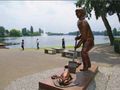
Just past the building and the water basin, you turn right. Here you actually walk through the old Scheldt bed, at the level of the current river bottom further on. Cross the Sluisstraat water treatment plant and climb the old canal dike. After 500 m you arrive at the Scheldedijk, where the 'new Scheldt' now flows, after it once broke through the narrow meander neck. To the left and right are pot polders, controlled flood plains. The dikes are lower. Follow the Scheldt to the right until you reach the castle of Uitbergen. Together with the Donkmeer walking route, you turn to the right. Then turn right again, into the Veulaerstraat, past the castle domain. Ignore the exit on the left. This is how you get to the Maeydonckbos (information board). Again in the old Scheldt meander, now occupied by swamp and trouser areas or meersen. In that forest you take the exit on the left at the branch. Via a narrow lane you leave the forest. On a concrete field road, choose on the right. Follow that concrete ribbon, first morning and then 1 km straight ahead, until recreation park Nieuwdonk. Turn left here and after 250 m turn right again into Paepenbogtstraat. At the entrance of the recreation park diagonally straight ahead. A cycling and walking path in red pavers leads you to the Brielstraat - the promenade on the lake - with the famous eel restaurants, boat rental, ferry, etc. On the way the entrance to the Duck Cage. At the end of the street is the statue of the Peat Cutter. Here you turn right into the Donklaan. (Follow this avenue = shortening to 10 km). Walk to restaurant Regina (no. 134) and then turn left into the Zandstraat (from here without signage). At no. 29 turn left into Strijdamstraat, direction campsite Gamma. Past the campsite you are again between forest and meadow. You bump into a water feature, where the path bends to the right. Further on, more water puddles, all flooded peat pits in the old Scheldt arm. These are home to cormorant, blue heron and rare breeding birds such as oriole, nightingale, kingfisher, etc. Continue until a wide T-junction and step left there. On the next T turn right again.
You continue to follow the old Scheldt bed, first in the Damweg and then straight on in the Kamershoek. A little past the bend, between nos. 6 and 8, you turn into the footpath, to the Berlare Broek. First between two water features and then the first exit to the left, through a wooden gate. Again protected nature reserve with picnic areas and information boards, far from the Donkmeer crowds. After 700 m, at a T-junction, a zigzag right-left, between wooden gates, and again through the trouser forest. Turn right at the next intersection. A long, straight private drive with a public character, also a cycling route, runs along a farm and turns into the Oude Dreef. This will take you back to the Donklaan, near the starting point.
Don't want to see this ad anymore?
→ Upgrade now
![]()
Please wait, the navigation is being prepared.
You can now navigate. Have fun on the road!
Processing your request has failed. Please try again.
Don't want to see this ad anymore?
→ Upgrade now
![]()
Please wait, your download is being prepared.
Your download is ready. Have fun on the road!
Processing your request has failed. Please try again.
Don't want to see this ad anymore?
→ Upgrade now
![]()
Please wait, your print is being prepared.
Your print is ready to download. Have fun on the road!
Processing your request has failed. Please try again.
Don't want to see this ad anymore?
→ Upgrade now
![]()
Please wait, your download is being prepared.
Your download is ready. Have fun on the road!
Processing your request has failed. Please try again.
<iframe src="https://plugin.routeyou.com/routeviewer/free/?language=en&params.route.id=5034252" width="100%" height="600" frameborder="0" allowfullscreen></iframe>
<a href="https://www.routeyou.com/en-be/route/view/5034252/recreational-walking-route/dry-meandering-in-donk?utm_source=embed&utm_medium=article&utm_campaign=routeshare" title="Dry meandering in Donk - RouteYou" target="_blank"><img src="https://image.routeyou.com/embed/route/960x670/5034252-en@2x.png" width="960" height="670" alt="Dry meandering in Donk"></a>
Additional feedback:
Try this feature for free with a RouteYou Plus trial subscription.
If you already have such an account, then log in now.
Try this feature for free with a RouteYou Premium trial subscription.
© 2006-2024 RouteYou - www.routeyou.com