2662 views | Public | Dutch
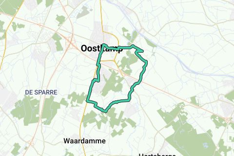
Appointment for the town hall of Oostkamp (V). At the back of the parking on the Pastorieplein (opposite the back of the church) you can park for a long time. If you come to Oostkamp by train, you can start the walk at the station (see below).
The town hall, in Flemish neo-Renaissance style, dates from 1882-1883. St. Peter's Church, on the same square, is a hall church with a 12th century Romanesque tower and a late Gothic nave. It has been protected since 1939. Walk right across the town hall into the Stationsstraat in the direction of Oedelem and after 120 m to the right in the Kapellestraat. Turn left 100 m further into a tarmac lane of young beech trees. At the end of the drive you will see an oak drive on the other side of the main road and behind it the Gruuthuysekasteel 1.
The Gruuthuyse castle is one of at least half a dozen castles and castle domains in Oostkamp, of which unfortunately none is accessible to the public. Turn left and turn right at the roundabout, again towards Oedelem. After 350 m at the fork, walk straight ahead, still in the Stationsstraat. On the right you see the entrance gate of the Gruuthuyse castle. After a right-angled turn you are at the station of Oostkamp 2. For those who come by train, the walk starts here.
Continue walking parallel to the railway line and after 450 m turn right into the Dolagestraat. At the end of Dolagestraat at the T-junction, turn right. Ignore Faliestraat and keep left. After 700 m you walk on the highway (A10 / E40) and you arrive in the Erkegem district. The large square water feature is the Erkegemvijver, a permanent spot for carp fishermen. On the main road, turn left and after 50 m turn right, direction Waardamme. Go straight across the Lebbe sugar factory to the right into Kampveldstraat nos. 16-18-20. The landscape becomes particularly quiet and rustic, with a nice variety of fields, meadows, rows of trees and lanes. After 750 m you will arrive at the Kampveldhoeve 3, a restaurant-tearoom where you can go for a refreshment on Saturday and Sunday from 3 pm. Leave the asphalt road and take the grass path to the left of the Kampveldhoeve to the beautiful oak drive. This will take you back to an asphalt road after 500 m. Move to the right. On the left is a trouser forest, where forest anemone and primrose bloom in spring. The asphalt road bends sharply to the right after 250 m. Walk to the left here on a wide dirt field road, first next to a willow row and draping into the open field. At the T-junction, turn right and after 150 m, right over an oak drive, turn left. Walk on the main road to the right along the N50. After 500 m turn right into the Hogendaledreef and another 120 m to the left in the Kunstschilderslaan.
Now walk for almost 700 m, always practically straight, parallel to the N50: in the right-angled bend of the Kunstschilderlaan straight ahead in the Dirk Boutsstraat - via a pedestrian path straight on to the Klauwaardstraat - after 100 m straight on in the Brugse-Mettenstraat - after 100 m just diagonally right via a pedestrian path and then straight on again on a two-lane concrete road, the Pieter De Coninckstraat. At the end of Pieter De Coninckstraat, turn right into Zannekinstraat and then left into Karel De Stoutelaan and at the intersection straight ahead into Jan Breidelstraat. Walk 75 m past a pedestrian and cyclist axis to the left to the N50. From here to the right, under the highway and along the N50 back to the center of Oostkamp.
Those who came by train go straight across the town hall to the right towards Oedelem.
Navigate route in...
![]() RouteYou app Open
RouteYou app Open
Don't want to see this ad anymore?
→ Upgrade now
![]()
Please wait, the navigation is being prepared.
You can now navigate. Have fun on the road!
Processing your request has failed. Please try again.
Don't want to see this ad anymore?
→ Upgrade now
![]()
Please wait, your download is being prepared.
Your download is ready. Have fun on the road!
Processing your request has failed. Please try again.
Don't want to see this ad anymore?
→ Upgrade now
![]()
Please wait, your print is being prepared.
Your print is ready to download. Have fun on the road!
Processing your request has failed. Please try again.
Don't want to see this ad anymore?
→ Upgrade now
![]()
Please wait, your download is being prepared.
Your download is ready. Have fun on the road!
Processing your request has failed. Please try again.
<iframe src="https://plugin.routeyou.com/routeviewer/free/?language=en&params.route.id=5294413" width="100%" height="600" frameborder="0" allowfullscreen></iframe>
<a href="https://www.routeyou.com/en-be/route/view/5294413/recreational-walking-route/by-rural-oostkamp?utm_source=embed&utm_medium=article&utm_campaign=routeshare" title="By rural Oostkamp - RouteYou" target="_blank"><img src="https://image.routeyou.com/embed/route/960x670/5294413-en@2x.png" width="960" height="670" alt="By rural Oostkamp"></a>
Additional feedback:
Try this feature for free with a RouteYou Plus trial subscription.
If you already have such an account, then log in now.
Try this feature for free with a RouteYou Premium trial subscription.
© 2006-2024 RouteYou - www.routeyou.com