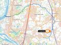
1367 views | Public | Dutch
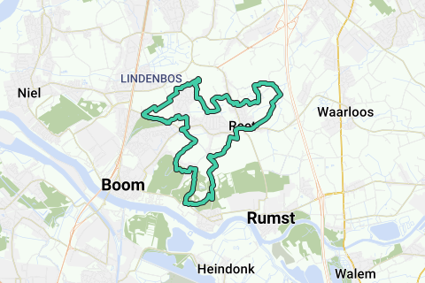
Go from the church (V) of Reet to KP208 at the Laarkapel 1 . Walk via BW24 to KP207. Turn left until you reach FP205. Take the Borzestraat on the left and walk until KP204. Turn left, direction 206. Step past the walled Schranshoeve 2 and continue on BW41. On FP206 continue straight ahead, direction 113. After a few bends you will arrive at the Eikenstraat. Step across the street into Donkerstraat. At the end turn left. Follow Clemenshoek until you can turn left into BW26. On FP113 turn right and on KP114 turn right again, direction 203. Continue walking until you can turn right into the Hoge Zandvelden. You enter BW13. On the T turn right until KP203. Turn left, direction 116, the path between two meadows. In a clearing, the path splits. Choose diagonally left and head into the forest. You walk along a football field and head back into the forest. Further on you take a forest path on the left, which takes you to a path that runs parallel to backyards to the Predikherenhoevestraat. Turn left and on KP116 turn right, direction 196. You walk on VW32 and turn left on KP196, direction 195. VW32 takes you to the 's Herenbaan. Cross, enter boom city park and walk left until KP195. Continue towards 117. Past an arched bridge you step out of the park. Cross the 's Herenbaan again and walk via VW34 to KP117. Cross the Predikherenhoevestraat and continue walking on VW34 to KP118. Turn right into Hazeweg, direction 115. At the end turn right again and at tavern Molenhuis 3 turn left. On FP115 turn right, direction 297. You walk past a garden fence, a row of pollard willows and through a stable built over the path. Past a bridge and a grass path you come to FP297. Continue straight ahead, direction 104. On the T turn right until KP104. Via a parking lot of De Schorre you reach KP200, on the slope for paragliders. Turn left, direction 199. In the forest you come to FP199. Turn left, direction 160. In the hamlet of Bosstraat you walk past the church and turn right into the Schoolstraat. At the end turn right and immediately left into the nature reserve of the old clay pits. On the left below you will discover two abandoned clay excavators and a flooded clay pit. The path becomes rougher and runs over stairs and decks. On FP160, go straight ahead, towards 276. At the fork, take the ascending path on the left. That will take you to KP276 in the Kapelstraat in Terhagen. On the other side there used to be drying sheds of the brick kilns. Turn left, direction 161. In the bend you go back into the terrain of the clay pits. Follow the gravel road to KP161 and continue through the forest to KP183. Take direction 192, cross a canal and continue walking until KP192. Now follow Hoogstraat 4, direction 159. The Hoogstraat used to be the connection between Terhagen and Reet. In the 50s of the last century, the hamlets of Eikerveld, Mussepotten and Wildernis disappeared for clay mining and the Hoogstraat ended in nothing. An orientation table was placed, but in the meantime the viewpoint has almost grown closed. Along the street there are signs about the former brick kilns. From the orientation table you descend via stairs to FP159. Turn right until KP193. Follow the gravel road, direction 182. You now step over the new Trage Weg (2012), which again connects Terhagen directly with Reet. The path rises and on the right you see the clay mining of the Wieneberger company. Go into the forest and on FP182 choose direction 158. Continue walking on VW50. Step over a parking lot and continue between fields and meadows to the parking lot of a supermarket. For FP158 you have to go straight. You take the field road on the right, before the car park. At the end turn left and just before Molenstraat turn right into the church path until you reach the church.
Abbreviations: BW = neighborhood road; VW = footpath; KP = node.
Navigate route in...
![]() RouteYou app Open
RouteYou app Open
Don't want to see this ad anymore?
→ Upgrade now
![]()
Please wait, the navigation is being prepared.
You can now navigate. Have fun on the road!
Processing your request has failed. Please try again.
Don't want to see this ad anymore?
→ Upgrade now
![]()
Please wait, your download is being prepared.
Your download is ready. Have fun on the road!
Processing your request has failed. Please try again.
Don't want to see this ad anymore?
→ Upgrade now
![]()
Please wait, your print is being prepared.
Your print is ready to download. Have fun on the road!
Processing your request has failed. Please try again.
Don't want to see this ad anymore?
→ Upgrade now
![]()
Please wait, your download is being prepared.
Your download is ready. Have fun on the road!
Processing your request has failed. Please try again.
<iframe src="https://plugin.routeyou.com/routeviewer/free/?language=en&params.route.id=5367065" width="100%" height="600" frameborder="0" allowfullscreen></iframe>
<a href="https://www.routeyou.com/en-be/route/view/5367065/recreational-walking-route/slow-and-adventurous-in-reet-and-terhagen?utm_source=embed&utm_medium=article&utm_campaign=routeshare" title="Slow and adventurous in Reet and Terhagen - RouteYou" target="_blank"><img src="https://image.routeyou.com/embed/route/960x670/5367065-en@2x.png" width="960" height="670" alt="Slow and adventurous in Reet and Terhagen"></a>
Additional feedback:
Try this feature for free with a RouteYou Plus trial subscription.
If you already have such an account, then log in now.
Try this feature for free with a RouteYou Premium trial subscription.
© 2006-2024 RouteYou - www.routeyou.com