1257 views | Public | Dutch
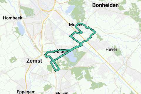
This 10 Miles loop (16.09km) starts at the church in Hofstade and goes in 8 form first along the Dijle (1st full loop) and then along the Senne (2nd full loop).
The place where these two loops of the 8 intersect is at the railway bridge 27B over the Leuvensevaart (Ambroosbrug).
On these 8 you can distinguish three running surfaces: Between the two basins the road is mainly asphalted/ paved; the Dylemeanders are paved; and the Zennemeanders are unpaved (field road and forest path). Both loops are completed in clockwise direction.
Beware of the intersection of both loops of the 8 on the Leuvensevaart: On the right bank (side Muizen-Mechelen, northeast of the canal) there is a path (with handrail) to the railway bridge. On the left bank (side Hofstade-Zemst, southwest of the canal) there is nothing, and you have to climb a few meters on the roadside to get to the bridge height. This small part is not really suitable for cyclists, unless you have strong muscles. It is better to cycle to the nearest Hofstade bridge (southeastwards) and there take the right bank (northwestwards). For runners and walkers this is doable for a sports enthusiast, just be careful not to get your hands into the thorns, or slide off the boulders. See the POIs near this Ambroosbrug for further tips (therefore first enlarge the map and zoom in to the crossing over the Leuvensevaart).
It is remarkable that this free descent / climb is already well frequented, making it easier every time to do the Zemst side of the cut of this 8.
The departure of the 16.09km loop is at the intersection of the Ambroossteenweg (Kerk Hofstade) with the Zusterstraat (50m northeast of the church). We take the shortest road to the intersection of the 8 (east direction, then follow the railway line 27B and cross it, then left along Prinsenveld to the Vaartbrug of the railway line 27B. On the southeast side of the bridge climb up the roadside, after which a separate pedestrian strip on this side takes you to the right bank. A path has been built over the bridge downstream (with handrail). Then back to the canal and follow the right bank north under the bridge to the past the Planckendael animal park and the siphon of the Barebeek under the canal, behind which we (steep and narrow) go down the canal verge turn right towards the center of Muizen. After the Leuvensesteenweg we follow the Barebeek 2x under the railway line, then take a left and follow the railway line north towards Mechelen. At the bicycle sheds of the train station Muizen we take right and arrive in Muizen-dorp. There we descend the Dijleberg and arrive at the Dijle which we follow on the right (upstream). Beware of car traffic at the Muizenbrug over the Dijle. A little further you walk over the mouth of the Barebeek in the Dijle (with a fantastic view over the landscape). A little further you come to an exit on the right just before a large fish pond. You take this until the end after which immediately left and right you come to a road that makes you cross a railway 2x (cobblestone road). On the Leuvensesteenweg you have to turn right 50m to take the Prinsenveldstraat on the left, along the railway line 27B, and return to the intersection of the 8.
Once back on the canal, we continue to keep the railway line 27B on our right via the Bloso domain. At the westernmost exit we follow the railway line to our right in the Vriezenbroek and after the bridge over the Barebeek take the first concrete road to the left, across the railway line 27B. There used to be a Senne crossing here, but this bridge has recently been demolished. This exit on the left allows us to follow the part of the Zennemeanders that lie east of the E19: Just behind the horse farm we take a right before that, the bicycle direction Elewijt (parallel to the Schumanlaan), but continue straight along the Schumanlaan until we arrive at the E19 which we follow in a bend to the right. A little further we see the Senne coming out from the left under the highway and meandering right into the Vriezenbroek. We enter a grove (sometimes thorny here) and pass another Sennemeander. We come close to the railway embankment 27B, where we follow the forest path on the right. We come back to the Senne and together with her take a cross under the railway line 27B, where we take the last remaining footbridge over the Senne between Weerde and Hofstade. We follow this side of the railway line, take the first left and follow the Senne on our left.
When the Zennemeander comes back to our left, the Barebeek is 150m on our right. This is the point where the Senne and Dyle basins are closest to each other. A unique place in the Dyle and Senne basins: Nowhere does a watercourse from one basin come so close to the main watercourse of the other basin.
We follow this slow road further (some bends) and notice in the distance the Diabolo train bridge Mechelen-Zaventem that descends between the E19, just at that place where the Senne dives back to the west side of the E19. Again a unique sight.
Just after the Diabolo train connection we take the field road on the left towards Hofstade. This field road was the historical connection over the Barebeek and the Senne between Zemst and Hofstade (source Ferraris map 1777). On the left, this road ran to next to the Senne (in the current bed of the E19) and followed it until just past the current bridge of the Brusselsesteenweg over the E19, where it went left via a bridge over the Senne to Zemst (near the old currently dead-end Brusselsesteenweg). However, we take the right towards Hofstade, arrive at the Barebeek and take the bridge over the Barebeek (Zemstsesteenweg), and follow it to Hofstade center. At the intersection with the Tervuursesteenweg the 16.09km is completed. The Church of Hofstade is on the right, 50m further.
Between the starting point behind the Church in Hofstade (Intersection Ambroossteenweg with Zusterstraat) and the arrival point at the end of the Zemstsesteenweg there is about 230m. So if you walk the loop completely, you have covered 16.32km, a fraction more than 10Mi.
In summary: a beauty of an 8 along adjacent basins above the Brussels.
Navigate route in...
![]() RouteYou app
Open >
RouteYou app
Open >
Don't want to see this ad anymore?
→ Upgrade now
![]()
Please wait, the navigation is being prepared.
You can now navigate. Have fun on the road!
Processing your request has failed. Please try again.
Don't want to see this ad anymore?
→ Upgrade now
![]()
Please wait, your download is being prepared.
Your download is ready. Have fun on the road!
Processing your request has failed. Please try again.
Don't want to see this ad anymore?
→ Upgrade now
![]()
Please wait, your print is being prepared.
Your print is ready to download. Have fun on the road!
Processing your request has failed. Please try again.
Don't want to see this ad anymore?
→ Upgrade now
![]()
Please wait, your download is being prepared.
Your download is ready. Have fun on the road!
Processing your request has failed. Please try again.
<iframe src="https://plugin.routeyou.com/routeviewer/free/?language=en&params.route.id=585509" width="100%" height="600" frameborder="0" allowfullscreen></iframe>
<a href="https://www.routeyou.com/en-be/route/view/585509/jogging-route/the-8-of-the-dijle-and-zenne-along-prinsenveld-16-09km-10mi?utm_source=embed&utm_medium=article&utm_campaign=routeshare" title="The 8 of the Dijle and Zenne along Prinsenveld (16,09km; 10Mi) - RouteYou" target="_blank"><img src="https://image.routeyou.com/embed/route/960x670/585509-en@2x.png" width="960" height="670" alt="The 8 of the Dijle and Zenne along Prinsenveld (16,09km; 10Mi)"></a>
Additional feedback:
Try this feature for free with a RouteYou Plus trial subscription.
If you already have such an account, then log in now.
Try this feature for free with a RouteYou Premium trial subscription.
© 2006-2024 RouteYou - www.routeyou.com