4517 views | Public | Dutch
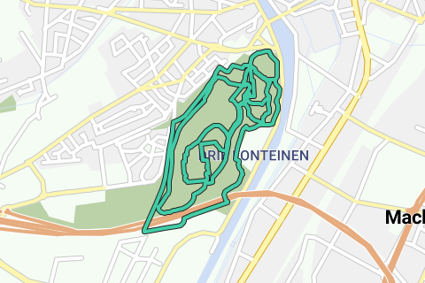
This route brings together three different loops of a total of 10km. She walks clockwise through the Three Fountains domain. It first goes through the largest (outer) loop of 3.80km, then the middle loop and finally the inner loop of 3.1km each. This is the most varied course for e.g. the jogger who wants to bring some momentum to his 10K. And the hiker will be able to take in all aspects of this park domain, strongly marked by history.
Historical information about this domain can be found here: https://inventaris.onroerenderfgoed.be/dibe/relict/70578
The route is suitable for walkers, runners and cyclists (The cyclists have to get off after 400m and go up about 90 steps; after the double crossing under the Great Ring, carefully drive down a few wooden steps, and halfway through the last loop get off twice very briefly for a few steps downhill). For the rest, the route is easily doable by bike.
For the sports enthusiast, this is a dream varied course with a lot of relief. Although this park zone is located on the Zeekanaal and the Senne, the paths are regularly sloping: on this side of the canal begins the hill country of 'Grim mountains', and you will have known: The height difference with the canal zone is easily 50m.
If it seems a bit too long to walk down in one go, you can find the three loops separately in the Routes tab of the group 'Vilvoorde sportive' and download them separately based on your expectations (family walk with the children, discovering unseen places, ..).
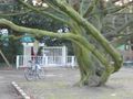
The park zone between the forests is largely laid out in English landscape style, so you can enjoy spacious views between the forests over lawns and tree avenues. The largest of these tree avenues gave out south onto a Castle (bombed in WWII), which gave east onto a French Garden and Orangery. On the Ruin of the former castle there is now a large square stone poduim with two works of art at the French Garden.
The departure and arrival point of each loop is located at the southern corner of the visitors' stand and the parking lot, located just against the Zeekanaal, just south of the Peace Bridge.
You can of course also start wherever these loops start (e.g. leave at the Brasserie Drie Fonteinen or the Playground (on the smallest loop) on the north side of the domain.
Detailed description with sights of the three loops:
OUTDOOR LOOP:
Typical sights along the way are (click on the POIs in the enlarged map): Old Hollow Roads, old (dilapidated) gatehouses, box crossing under the Great Ring, observation of the Great Ring along the bottom (you get a fairytale spectacle on the curved Ring and bridge levelers. In the past, this was a very daring piece of civil engineering (longest crooked crossing. See http://wegen-routes.be/doss/R0n.html, http://www.deredactie.be/cm/vrtnieuws/mediatheek/programmas/journaal/2.16030/2.16031/1.1042608, and http://www.wegenenverkeer.be/over-awv/multimedia.html).
Also a
pond that opens through a crater onto a pond the imaginative Blood Caves, beautiful and large old trees, low-lying ponds and various sports fields.
Route: This loop starts with a wide lap around the athletics track (first walk until just before the exit of the parking lot, then left, and then keep the path on the right) and takes two stairs on its north side of the athletics track (fenced: this is the first right on the triple jump at the low buildings (See POI). We then pass a higher tennis court and even higher a football field; and take the exit to the right of this football field to the district 'De Kassei'. We follow this exit until just past the buildings on the first transverse street; Just before that turn left into the forest. This narrow path becomes a bit wider and deeper under the surrounding tree zone: We are in the old hollow roads on the edge of the domain (paved - cobblestone - asphalt - earth road). The first hollow road (Oude Steenweg on Koningslo) takes you past two dilapidated entrance pavilions. A little further you have to turn left (Holle weg Blaesenberg) of which the first part is occupied by one-way car traffic (beware). A little further it is traffic-free again. This Hollow Road then briefly rises to forest height (crosses the northern entrance road to the domain), and then dives back into the depths. We come under a pedestrian bridge and descend further to the Ring around Brussels (this last part to the Ring can be dirty in the wet season). It protrudes through an unlit tube under the Ring around Brussels (enough light to walk safely through it (asphalt)). Behind the crazier, take a left and follow the Ring on the Brussels side towards Zeekanaal (first some ascent, then down via an asphalt road). The viaduct also starts from the asphalt road, which is supported by ever higher bridge levelers. Follow this road (with its impressive panorama of the supporting structure of the large bend in the Ring) until just past the first two three-lane-wide bridge levelers, behind which you turn left back under the Ring (under the Ring it is uphill). This is past a dead-end paved exit on the left and over a bridge over a narrow pond that lies on the left under the Ring in an increasingly deep gorge. Keep this puddle and gorge on your left until you have reached the other end of this gorge: First this is on an unpaved path (watch out for some wooden steps downhill along the gorge), then paved, and then you come across an old asphalt road (which ran through the domain, but is now interrupted halfway) that you take a left up.
At the lake on the left, notice a beautiful two-deck water crossing. The lower water crossing (just above the water level) is known in the region as the 'Blood Caves'. According to legend, traces of blood from disappeared people have reportedly been found there. For children this is a nice hiding place. However, we leave the bridge on top of these Blood Caves. When we reach the end of the water on the other side of the blood caves, we leave the steep asphalt road and take the forest path along the gardens of the Lenterik district.
This forest path leads to a paved path that we take on the right and keep right along the lowest ponds in the domain.
At the end of these ponds we arrive at the buildings of a (covered) tennis court, which we keep on our left (so stay between these buildings and the Brusselsesteenweg on the Zeekanaal). Behind these buildings is a narrow exit (a few steps) to the parking zone where the starting point of this first loop is located; and also the starting point of the second loop (middle loop).
MIDDLE LOOP:
Detailed description with sights of the second loop (See the POIs after enlargement of the map): Lendrikskapel, many large old trees, beautiful panoramas over grassy plains and (wide) avenues, hollow roads that are visibly hidden in the depths of the forest,
Route: Keep the grandstand of the athletics track on your right and the further low buildings on your left. You end up at the same triple jump at the beginning of your first loop. Now you take the second one on the right, just to the left of the stairs: steep paved road to the highest football square. When you notice the drain wire on your left, do NOT take the right turn - visually towards Lendrikskapel-, but leave this path before the bend to LEFT: exit fence. After 5 meters you come outside the fence and take the T immediately right up outside the fence, direction Lendrikskapel. At the top you leave the Lendrikskapel and follow 30m outside fence of the football square. A little further from the fence there is a fork in the forest path, take there to the right so that you seem to end up right on the hollow road. 10m before that you come to a T where you take the forest path on the left (parallel to the Hollow Roads on your right. You arrive at the inside of the dilapidated Tower Buildings after which the path is paved. On the left you follow the immense grass meadow with several large old trees on the paved path. Keep following this paved path at a crossroads on the right until past a pedestrian bridge over the hollow Blaesenbergweg on your right (on the left you have the wide tree avenue where the castle stood at the end; on the horizon on the right you have the VTM buildings.)
Past this bridge you come to a crossroads where you take the right (unpaved forest path). Via a large bend, this path comes parallel to the Great Ring that you no longer cross, but keeps on your right side.
A little further this path moves away from the Ring and it ends up at a T with a paved (cinder) path: take right there.
You come down to the wide tree avenue and you keep the raised stone stage (where the castle stood) on your left (turn left behind the stage, direction French Garden). You leave the French Garden to the left and you take the paved road to the right of it; Keep following it on an asphalt road (which dead ends on the left). After this asphalt road you continue straight ahead (small path joins on the left, then a Y-junction that you take on the right). After this Y, take the paved path to the right in the descent (50m before you end up on the large grass meadow). Follow this paved path (Ganzenvoetweg) in a bend to a clearing with panoramic views on your left (so do not take the unpaved Brugweg down into the forest on the left). In the bend of this grassy plain you take a small path on the left steeply down that leads directly to the low-lying ponds. At these ponds you take a moment on the right and immediately on the left: you follow the pond just on your right.
At the end of this pond you keep the covered tennis building on your right (on the left you have an open tennis court): you follow this path between both tennis courts until the exit to the car park, where this second loop ends, and also the starting point of the third loop (inner loop).
INNER LOOP:
Typical sights of the third loop are (click on the POIs in the enlarged map):
The Lendrikskapel and most other park buildings (particularly beautiful): a farmhouse with stables and an imposing hunting pavilion; a (largely preserved) masonry water tower; the imposing coach house with stables in a large courtyard (used for cultural activities), the Brasserie de Drie Fonteinen (a dilapidated Orangery before the renovation) with a French Garden; A large playground and a small park with farm animals in the summer are on the route.
Route: Keep the grandstand of the athletics track on your right and the low buildings behind on your left. You end up at the same triple jump at the beginning of your first and second loop. Now you take the third one on the right, just against the low buildings. You come to the rear of the last low-lying football square (fence), and you follow it on your left to a tennis court; take the right there and keep going uphill here in the zigzag until you reach the Lendrikskapel (for example, you come to a T in the path that you take to the right). You now keep the Chapel to the right and you continue down the grass meadow next to the chapel and at the front of the chapel. On the grassy plain you cut a paved path that you take to the left and keep following. A little further take the first paved path to the right, which takes you back along the grassy plain. On the left you pass the playground, take immediately left behind it, and follow the farm, stables and the park ranger's building (hunting pavilion) on your right (cobblestone strip). Cross the asphalt road and follow the large coach house in front of you on your left, you pass a tower building on the right and arrive at the front of the coach house, where you take the tree avenue to the left 30m further. At the French Garden take a left and you go through the French Garden towards Orangery (Brasserie Drie Fonteinen). At the entrance of the Brasserie take left and immediately right and follow the tree-lined avenue with the playground to your left, and the brasserie car park to your right. Behind this parking you take the paved path on the right that goes down between two buildings. Attention: behind these buildings you have two small stairs down: Get off your bike there or moderate walking speed. Follow the zigzag of this path and turn left at the T.
At the Y-junction you take the right, and in the descent (50m before you end up on the large grass meadow) you take the paved path to the right (Ganzenvoetweg). Follow this path to the bend (not to the higher grassy plain), and turn left onto the Brugweg (unpaved forest path) down. Below you pass remnants of a bridge over a forest stream, after which the path paved back up. On this path you take the first right that takes you to the fence of a tennis court. Take the right and follow the tennis court on your left. You come to a T at the low-lying ponds where you take two left. At the end of the pond you have a covered tennis building that you leave on your right side and a tennis court that you leave on your left. Take this paved path to the car park where you have completed your third loop at the stands and you have completed 10km.
Navigate route in...
![]() RouteYou app Open
RouteYou app Open
Don't want to see this ad anymore?
→ Upgrade now
![]()
Please wait, the navigation is being prepared.
You can now navigate. Have fun on the road!
Processing your request has failed. Please try again.
Don't want to see this ad anymore?
→ Upgrade now
![]()
Please wait, your download is being prepared.
Your download is ready. Have fun on the road!
Processing your request has failed. Please try again.
Don't want to see this ad anymore?
→ Upgrade now
![]()
Please wait, your print is being prepared.
Your print is ready to download. Have fun on the road!
Processing your request has failed. Please try again.
Don't want to see this ad anymore?
→ Upgrade now
![]()
Please wait, your download is being prepared.
Your download is ready. Have fun on the road!
Processing your request has failed. Please try again.
<iframe src="https://plugin.routeyou.com/routeviewer/free/?language=en&params.route.id=610162" width="100%" height="600" frameborder="0" allowfullscreen></iframe>
<a href="https://www.routeyou.com/en-be/route/view/610162/jogging-route/3-loops-in-three-fountains-10km?utm_source=embed&utm_medium=article&utm_campaign=routeshare" title="3 loops in Three Fountains (10km) - RouteYou" target="_blank"><img src="https://image.routeyou.com/embed/route/960x670/610162-en@2x.png" width="960" height="670" alt="3 loops in Three Fountains (10km)"></a>
Additional feedback:
Try this feature for free with a RouteYou Plus trial subscription.
If you already have such an account, then log in now.
Try this feature for free with a RouteYou Premium trial subscription.
© 2006-2024 RouteYou - www.routeyou.com