Overview:
From Chandolin there are plenty of options to go hiking, and in this guide we'll take you to the high lake of Illsee and the Meretschi Alp.
In Chandolin there are parking spots in the center of the village, there is no free parking in the village. The hike starts at the tourist office, in the center of the village.
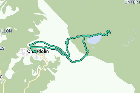
To start of the hike we climb immediately in the direction of the first mountain pass called "Pas de l'Illsee". From this mountain pass you can also visit the Illhorn, with a height of 2716m), from this summit you'll get an amazing view over the Rhone valley. We advise you to only do it when you are in good condition because we have an other climb ahead of us to the Meretschi alp. It's an additional climb of about 200m extra climbing.
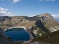
When reaching the summit of Pas d'Illsee we already can see the lake in its full glory. From here you'll also get a nice view on the destination of the hike: the Meretschi Alp. From the mountain pass we descent to the lake of Illsee. It is an artificial lake with a small barrage where we walk over. Once passed, the climb to the Meretschi awaits.
When you reach the Meretschi Alp, look behind you and be amazed by the view on the closest mountain summits and the further on the Rhone Valley and the higher mountains further on. It is an ideal place to have diner here before heading back to the village.
To return to Chandoin we ascend back to the lake but after the refuge we walk in the direction of the second mountain pass: Illpass. This piece of the hike is not guided with the familiar yellow roadsigns, it is a cow path that runs to the Illpass. Just beneath the ill pas, the path is a bit rockier, so be a bit more careful. Once reached we can set to our final descent to the village of Chandolin. We do not take the bigger road to "le Tsapé" but instead of that we'll take the mountain path to "La Grande Remointse". It's a more desolated and pure path with more chances to see some wildlife.
From "La Grande Remointse" it's time to take the shortest possible route to Chandolin. Just follow the yellow roadsigns towards the village.
Hike classification: T2 - Mountain hike
Vertical up: 926m
Vertical down: 897m
Story:
Today we where headed to the Meretschi alp. It is situated above the lake of Illsee at Chandolin. The Hike starts in Chandolin where we take the direction of Pas de l'Illsee and Illhorn. When we reach the mountain pass we already see the lake of Illsee and the barrage. Surprisingly the dam/barrage is under construction, the past years the barrage wasn't in great shape with water leaking away. Now the barrage is a large construction site until the end of 2012. Hikers can still cross it, although when hiking towards it we hesitated a bit. Once crossed, we climb up the Meretschi alp from where we have a nice view on the Illhorn, Illssee, Schwarzhorn, Rothorn and Bella Tolla.
We do not return the exact same route, when climbing down to Illsee we'll go searching for a 'path' to Illpass. Once reach we take the mountain path towards La Grande Remointse and thereafter the shortest route to Chandolin.
Tips:
- When returning from Meretisch, we take a half existing path to get to Illpass.
- A bit rocky path, but no problem with good equipment.
Don't want to see this ad anymore?
→ Upgrade now
![]()
Please wait, the navigation is being prepared.
You can now navigate. Have fun on the road!
Processing your request has failed. Please try again.
Don't want to see this ad anymore?
→ Upgrade now
![]()
Please wait, your download is being prepared.
Your download is ready. Have fun on the road!
Processing your request has failed. Please try again.
Don't want to see this ad anymore?
→ Upgrade now
![]()
Please wait, your print is being prepared.
Your print is ready to download. Have fun on the road!
Processing your request has failed. Please try again.
Don't want to see this ad anymore?
→ Upgrade now
![]()
Please wait, your download is being prepared.
Your download is ready. Have fun on the road!
Processing your request has failed. Please try again.
<iframe src="https://plugin.routeyou.com/routeviewer/free/?language=en&params.route.id=2260418" width="100%" height="600" frameborder="0" allowfullscreen></iframe>
<a href="https://www.routeyou.com/en-ch/route/view/2260418/hiking-route/from-chandolin-to-the-meretschi-alp?utm_source=embed&utm_medium=article&utm_campaign=routeshare" title="From Chandolin to the Meretschi alp - RouteYou" target="_blank"><img src="https://image.routeyou.com/embed/route/960x670/2260418-en@2x.png" width="960" height="670" alt="From Chandolin to the Meretschi alp"></a>
Additional feedback:
Try this feature for free with a RouteYou Plus trial subscription.
If you already have such an account, then log in now.
Try this feature for free with a RouteYou Premium trial subscription.
© 2006-2024 RouteYou - www.routeyou.com