939 views | Public | Spanish
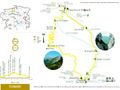
Els Empedrats (PR C 125)
Technical data
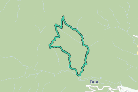
Approximate distance: 11 kilometres
Approximate duration: 5 hours
Signposting: Yellow and white waymarks along the route (PR-C 125)
Starting and finishing point: Neighbourhood of L'Hostalet, on the track from Bagà to the source of the Bastareny
Car park: Parking of the neighbourhood of L'Hostalet
Points of interest:
Bullidor de la Llet whirlpool, Els Empedrats, Escriu gorge, Font Gran d’Escriu spring, Faig spring, Galligans pass, Boixassa pass and excellent views of the Cadí and El Moixeró ranges
Services:
Sant Jordi hut
For other services in the area consult the section on tourist services
Comments:
In the area of El Empedrats you must be careful not to slip, especially during the winter. If it's raining, bear in mind that a sudden rise in the water level of the river is possible.
Between La Pelosa and La Ribereta, the characteristics of the terrain make it a little hard to see the path in many places. Try not to lose sight of the waymarks.
Maps:
El Berguedà 1:50.000. Institut Cartogràfic de Catalunya
Moixeró – La Tosa 1:25.000. Editorial Alpina
Introduction
This itinerary has two quite different sections: the ascent is made along the old La Cerdanya high road — cool and shady — that follows the Pendís river valley, which you have to wade through in many places. To make up for this, the descent crosses the back part of La Boixassa, wide and sunny, with vast views and a complete absence of water.
As a token of its importance, the uphill path was cobbled in many parts to avoid erosion, especially on the slopes. You can still see the stones driven in on their sides.
Description of the route
The route starts at the neighbourhood of L’Hostalet. At the beginning of the itinerary there are two houses. Next to the Dou track is Cal Cerdanyola, which once had a mill that used the waters of the Pendís river. The Hostalet house is on the other side of the river, next to the path that goes up to the Pendís pass via Els Empedrats. Although in ruins, you can still make out the structure of a 16th century farmhouse that was later added to as it was used as a hostel for the high road of La Cerdanya.
Start climbing up along the bank of the river that you cross after about 15 minutes to the left side of the Empedrats bridge. From here you can easily see the impressive splay crevasse cut by the waters into the limestone rock. Before going along the Empedrats ravine, you will come to a path that emerges from the left and fords through the river — it is usually indicated with a post. This path leads to what is known as the Bullidor de la Llet, an impressive whirlpool in fissures of the limestone rock. You get there after a short but very steep slope but it is only of real interest in rainy seasons; in summer and winter it is usually dry.
From this point, the path goes right into the riverbed and skirts the imposing rock obstructing the river: this is the area of Els Empedrats. There is now a mixture of river and path so you should keep on the stepping stones. If a lot of water is flowing you will be sure to get drenched!
You will now soon come to the Escriu gorge. This is a very beautiful spot where the path keeps above the river that leaps and glides among the rocks. Right in the bed of the stream is the Gran d'Escriu spring, which is only visible when there is little water coming from the main valley. The spring is found a few metres from where the stream crosses a track coming from the Escriu house, in ruins.
Just when you get to the top, you will see the Sant Jordi hut and the link with the GR 107 (Camí dels Bons Homes – Cathars Route). The hut is open in the months of June, July, August and September. When there is no caretaker and the refuge is closed, there is a free part at the back but it is very primitive and only advisable in case of emergencies. Next to the hut there is also a fountain; if it's not working, go and look for the old Faig spring, located in a small cavern under a huge poplar west of the hut. You have to go by the side of the ruins of the old Font del Faig house. It always seems to flow, even in years of drought. The path you must take goes alongside the spring and up to cross a white crag.
You soon reach the Galligans pass, a narrow pass from where you enter the Galligans valley, the head of La Boixassa and its long crag that seems to bar the way of Els Empedrats. The head of the Galligans valley was once an area of pasture meadows but is now much reduced in size. Below the path, hidden in the vegetation, is the Galligans shepherds hut, a circular stone edifice with a slate dome.
At the head of this valley there is a crossroads. Take the path that goes below the head of La Boixassa, level with the cliff.
From here you can take in great views to the west, with El Cadí and El Pedraforca as a backdrop and the stretching Bastareny valley at your feet. You can see why this mountain is called the 'forked rock'. Box trees feature in this stage, and the adverse weather conditions they have to withstand give them a different colouring according to the season: red tones in winter that become green in the spring and in rainy seasons.
When you get to the Pelosa pass, on the right you will find the connection with the track going up from Monnell. Though it hardly seems possible, there was once a house in this spot: La Pelosa. The ruins are found beside the path, covered by brambles, near a pond there. You will be treading on the crop fields of this house on the nearer flank, the walls of the crop terraces are hidden among the vegetation and the stony ground on the slope. Keep your eyes open because a few metres past the pond you have to leave the track and go on a trail going left.
Beside the stream, under La Pelosa, are the Cal Quim caverns. The path smoothly flanks the wide, stony, pointed heads of the Cal Quim stream. You go below the Boixassa caverns before entering the Riberetes coombe.
When you go into this coombe, on the side facing east, there are crop terraces that would have led from the Boixassa or Pelosa caverns, depending on the period. When you go into the main stream it becomes dark again. You are entering coal bunker country, only visible to trained eyes; they are usually round in shape and form a ramp that breaks the slope, they normally use the bed of the stream and there are always pieces of coal lying about.
When you get to the Dou track, if you still have enough energy, you can keep going a few more metres towards the river and, next to the bridge that cross the Bastareny river, you will see the ruins of the Forat mill, converted into a house in the 19th century.
Navigate route in...
![]() RouteYou app Open
RouteYou app Open
Don't want to see this ad anymore?
→ Upgrade now
![]()
Please wait, the navigation is being prepared.
You can now navigate. Have fun on the road!
Processing your request has failed. Please try again.
Don't want to see this ad anymore?
→ Upgrade now
![]()
Please wait, your download is being prepared.
Your download is ready. Have fun on the road!
Processing your request has failed. Please try again.
Don't want to see this ad anymore?
→ Upgrade now
![]()
Please wait, your print is being prepared.
Your print is ready to download. Have fun on the road!
Processing your request has failed. Please try again.
Don't want to see this ad anymore?
→ Upgrade now
![]()
Please wait, your download is being prepared.
Your download is ready. Have fun on the road!
Processing your request has failed. Please try again.
<iframe src="https://plugin.routeyou.com/routeviewer/free/?language=en&params.route.id=497044" width="100%" height="600" frameborder="0" allowfullscreen></iframe>
<a href="https://www.routeyou.com/en-es/route/view/497044/hiking-route/els-empedrats-prc-125?utm_source=embed&utm_medium=article&utm_campaign=routeshare" title="Els Empedrats - PRC 125 - RouteYou" target="_blank"><img src="https://image.routeyou.com/embed/route/960x670/497044-en@2x.png" width="960" height="670" alt="Els Empedrats - PRC 125"></a>
Additional feedback:
Try this feature for free with a RouteYou Plus trial subscription.
If you already have such an account, then log in now.
Try this feature for free with a RouteYou Premium trial subscription.
© 2006-2024 RouteYou - www.routeyou.com