1183 views | Public | Dutch
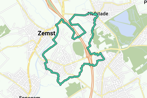
This loop of 12.7 km is built around as many important and historic neighborhood roads as possible around the former hamlet 'De Brug' in Zemst, located on the crossing over the Senne towards Mechelen (http://nl.wikipedia.org/wiki/De_Brug_%28Zemst%29 and http://nl.wikipedia.org/wiki/Zemst#Belang_van_de_waterlopen). See also the POIs in the route.
Would you like a high-resolution photo of the loop on the Atlas of Local Roads?
https://picasaweb.google.com/lh/photo/sjx8q98ruSSs7AgaYJ0KrNMTjNZETYmyPJy0liipFm0?feat=directlink
and use the 'download' button there.
The hamlet 'De Brug' fulfilled a central traffic junction south of Mechelen. The North-South axis Brussels-Antwerp had a crossroads on the Senne. This Senne crossing also realized an East-West connection between Hofstade-Muizen (Dyle basin) and Weerde-Eppegem-Grimbergen (Senne basin).
If you already want to be surprised on this surprising walk along this piece of old heritage of Zemst-Weerde-Hofstade: watch this specially made video:
Surtitle: "ODE TO SLOW ROADS" http://youtu.be/IYxunRYC5Dk (1080p original), so playable in any format.
This hamlet and many roads from the Atlas of Local Roads have been demolished, disappeared, or closed to King Auto by the arrival of the E19.
Because the intention is to only go along (as many quiet and rural roads as possible) Neighborhood ('Chemin') or Foot (Sentier) roads, you will come across a variety of locations. In this loop, even two original slow roads are used to cross the E19. Strictly speaking, these E19 passages are not designed as such, but a trail runner, or an adventurous hiker will have no problem with it. HOWEVER: THESE ARE TO BE ENTERED AT YOUR OWN RISK.
The GPX of this loop starts at the old dump of Zemst, just north of the Zennever discount. Previously, this was a low-lying soggy area. During the construction of the Brussels-Antwerp Railway, a road was raised between Zemst and Weerde with a bridge over the Zenneverkorting (just at the Zemst landfill): De Stationslaan. As the name suggests: it was built to allow the Zemstenaars to enjoy the modern new railway connection. The starting point of the loop is therefore a historic location in itself!
A number of Neighbourhood and Footpaths have disappeared, been relocated and rebuilt, and a number are still in their original state. See this POI that shows the Traillus on top of the Atlas of Local Roads:
If you want a print to take with you: take this enlargement:
The most important changes in the Buurtwegen network were made by the construction of the E19 (1972).
E19-passage 1 = on the E19 = Route 26 - Buurtweg 48
The crossing between Weerde and Hofstade runs along railway line 27b (CROSSING AT YOUR OWN RISK!).
E19 passage 2 = below E19 = Footpath 22.
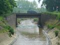
On the border between Elewijt and Weerde, an original 'Gué' (ford) of Buurtweg 8 - Buurtweg 4 through the Barebeek is used. This is the Roman Heirbaan that still bears this name in Elewijt. She had a mudflat on the Barebeek, so the mudflats are also used here. (In the dry season this 'Gué' is still half a meter deep, but on the Weerdeoever it rises quickly, but here you have fairly deep mud that you can stumble into. Keep your balance on this shallow roadside. So you don't enter Weerde with dry legs! (= about halfway if you take the GPX starting position)
Over the Barebeek, Buurtweg 4 is overgrown and no longer permeable because the E19 has interrupted this neighborhood road. The Barebeek is therefore followed upstream on its left bank until you reach the mouth of the Hondsleibeek, just next to the E19. Along the Hondsleibeek was Voetweg 22, which was also interrupted by the E19.
The GPX takes you through a 1.6m high tube from the Hondsleibeek to the other side of the E19 (so you take Voetweg 22 to reach the other side of the E19. Just past the E19 you can easily take back the entrance (right) with the Buurtweg 4, which still exists on this side of the E19, runs up to the Senne, and then follows the right bank upstream, towards Weerdemolen.
The Hondsleibeek tube is fairly dry for most of the year. 'Walking' through it is not advisable because of the height, but walking through it is. A running lamp may be welcome for some in this place: PASSAGE AT YOUR OWN RISK.
In itself, this loop is not that long for runners or walkers, and it runs on a mixed asphalt-paved-unpaved and a fordable trail: This is to follow the original Slow Roads as much as possible.
The special thing about this loop is experiencing the historic (and therefore important) Neighborhood Roads in a current context.
This trip is not for the faint of heart: It is an adventure worth experiencing!
Navigate route in...
![]() RouteYou app Open
RouteYou app Open
Don't want to see this ad anymore?
→ Upgrade now
![]()
Please wait, the navigation is being prepared.
You can now navigate. Have fun on the road!
Processing your request has failed. Please try again.
Don't want to see this ad anymore?
→ Upgrade now
![]()
Please wait, your download is being prepared.
Your download is ready. Have fun on the road!
Processing your request has failed. Please try again.
Don't want to see this ad anymore?
→ Upgrade now
![]()
Please wait, your print is being prepared.
Your print is ready to download. Have fun on the road!
Processing your request has failed. Please try again.
Don't want to see this ad anymore?
→ Upgrade now
![]()
Please wait, your download is being prepared.
Your download is ready. Have fun on the road!
Processing your request has failed. Please try again.
<iframe src="https://plugin.routeyou.com/routeviewer/free/?language=en&params.route.id=1620868" width="100%" height="600" frameborder="0" allowfullscreen></iframe>
<a href="https://www.routeyou.com/en-be/route/view/1620868/hiking-route/buurtwegen-aan-de-brug-12-7km?utm_source=embed&utm_medium=article&utm_campaign=routeshare" title="BuurtWegen aan De Brug (12,7km) - RouteYou" target="_blank"><img src="https://image.routeyou.com/embed/route/960x670/1620868-en@2x.png" width="960" height="670" alt="BuurtWegen aan De Brug (12,7km)"></a>
Additional feedback:
Try this feature for free with a RouteYou Plus trial subscription.
If you already have such an account, then log in now.
Try this feature for free with a RouteYou Premium trial subscription.
© 2006-2024 RouteYou - www.routeyou.com