12602 views | Public | Dutch
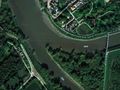
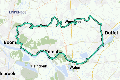
The Nete flows into Rumst together with the Dijle and forms the Rupel, which flows into the Scheldt 12 kilometres further. In the vicinity of this three-river point you can see some interesting projects that the province has realized to combat flooding. Discover it on this cycle route.
Navigate route in...
![]() RouteYou app Open
RouteYou app Open
![]()
Please wait, your print is being prepared.
Your print is ready to download. Have fun on the road!
Processing your request has failed. Please try again.
![]()
Please wait, your download is being prepared.
Your download is ready. Have fun on the road!
Processing your request has failed. Please try again.
<iframe src="https://plugin.routeyou.com/routeviewer/free/?language=en&params.route.id=2918008" width="100%" height="600" frameborder="0" allowfullscreen></iframe>
<a href="https://www.routeyou.com/en-be/route/view/2918008/recreational-cycle-route/veleau-3-river-route?utm_source=embed&utm_medium=article&utm_campaign=routeshare" title="Veleau 3 River Route - RouteYou" target="_blank"><img src="https://image.routeyou.com/embed/route/960x670/2918008-en@2x.png" width="960" height="670" alt="Veleau 3 River Route"></a>
Additional feedback:
Try this feature for free with a RouteYou Plus trial subscription.
If you already have such an account, then log in now.
Try this feature for free with a RouteYou Premium trial subscription.
© 2006-2024 RouteYou - www.routeyou.com