8795 views | Public | Dutch
A word of history.
Michelbeke, a small village in the Zwalm valley, is located in the Flemish Ardennes. Since this walk will lead us over the slopes, along the coulters and through the valleys of this region, the origin of this landscape deserves a little explanation. The hills of the Flemish Ardennes were formed during the Miocene (between 20 million and 5 million years ago), when tectonic shifts pushed up the Earth's crust. The hilltops – known from the Tour of Flanders – have their origins in the tidal action of the Diestian Sea, which then regularly flooded the country. The sand that was deposited was rich in glauconite. Glauconite contains a lot of iron, and after the Miocene, when the sea finally retreated, these ferruginous sands rusted together into iron sandstone. This formed a hard layer that was more resistant to erosion by wind and rain than the surrounding softer layers.
The sanding of the rivers during the Quaternary (ca. 2 million years ago) put the landscape in its current fold. Sand retains a lot of water, but clay is impermeable. Every time a river cut through such a clay layer, springs arose (such as this one on top of the Berendries in Michelbeke). One of those rivers is the Zwalm. The source area is located on the ridge (150 m) of Vloesberg (Flobecq), but it is only from Brakel that the stream is called Zwalm. A possible explanation for the name Zwalm comes from swelling. In case of heavy rainfall, the Zwalm can grow strongly. After all, it is exceptional for Flanders that a river at a distance of 19 kilometers bridges a height difference of about 60 meters, so that it carries a lot of energy – witness also the various water mills along the course, with the Boembeke mill as the highest. The Zwalm valley is asymmetrical with gentle slopes on the western side and steeper ones on the eastern shore. The calf-biter Berendries is also an example of this.
The first settlements in present-day Michelbeke had nestled in the wooded Zwalm valley. The name comes not coincidentally from the contraction of two Germanic expressions referring to water: 'migilo' or urine-like mud and 'beca' or stream. Nevertheless, there was already the necessary passage in the region for the Germans. The road from the Roman army camp at Velzeke to Bavay in northern France ran through the later Michelbeke.
However, the oldest mention of the name 'Mighelbeca, apud Migelbecam' dates back to the early 12th century. In the Middle Ages, the settlement was part of the Tenement of Inde: a territory of about 20 municipalities on both sides of the current language border. This area was used by Louis the Pious - what's in a name! - donated to a Benedictine abbey along the Inde, a river near Aachen (early 9th century), but after the raids of the Normans it came into the hands of the Saint Hermes chapter in Ronse. Most of the Tenement was later purchased by the Count of Flanders, Consecrated of Dampierre, who in turn gave it to his son Guy of Namur in 1289. This made Ronse the religious and business center of the region. The patronage over the parish church of Michelbeke was therefore exercised by the chapter. It was dedicated to Sint-Stefaan and later (from 1619) to Sint-Sebastiaan. The latter saint was worshipped to protect the animals from the plague that was then rampant.
In the middle of the 17th century, the lordship of Michelbeke was sold to Pieter Blondel, lord of the castle in Sint-Maria-Oudenhove. In 1675, the lord of the castle united the lordships of Michelbeke, Lilare, Riede and Sint-Maria-Oudenhove in the barony of Sint-Maria-Oudenhove. A reward by King Philip IV of Spain for services rendered as a councillor in the administration of the Netherlands during the Spanish occupation.
When the municipalities were founded in 1795 during the French occupation of the Southern Netherlands, Michelbeke and Sint-Maria-Oudenhove were separated again. Thus, despite the changes of power, life continued quietly in this agricultural community. The income from agriculture was supplemented by some domestic textile industry, as often happened in these regions in the 19th century. The construction of railway line 82 at the end of that century, which connected Aalst via Zottegem, Brakel and Ronse to the coalfield in the Borinage (Hainaut), made freight transport and commuting of miners possible. Many men who lived along this railway tried their luck in the mines. The cheap and later free train subscriptions made it possible to continue living in the countryside where life was healthier than in the overcrowded cities. They were long days nonetheless. In 1963, after the closure of mines, this line was abolished and opened in 1978 as a recreational walking and cycling path.
On 1 January 1971, in the second major merger round, Michelbeke was merged into the newly created municipality of Brakel. Agriculture and commuting to Brussels are important parts of economic activity, but tourism to this blissfully rolling beautiful region is taking on an ever-increasing share. And for that we count on you!
Introduction
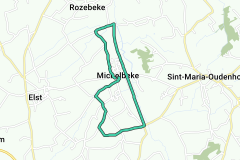
The Zwalmpad is a path for beginners, feasible for all age categories. It is about 8 km long, which means a short two-hour walk. The entire path is paved, so accessible to strollers. Of course, keep in mind that there is a bit of uphill here and there, but nowhere is the gradient of that nature to cause problems. After all, the lion's share of the path is located on the gently sloping flank of the Zwalm valley. Mainly quiet neighborhood and field roads are followed and where the Zwalmpad briefly follows the route of the Miners' Path, the walk is even completely car-free.
The path is indicated by hexagonal signs with green borders on which the name is clearly stated. In the route description, a small excursion away from the path is suggested here and there, to a place of interest, an attraction for the children or a thirst quencher, for example, but of course you choose yourself.
The starting place is located on Sint-Sebastiaanplein, where you can also park your car. If you don't find a place there, there is also the nearby Riedeplein. Happy hiking!
Route and sights
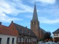
On Sint-Sebastiaansplein, the starting point of our walk, is the church of the same name. The Classicist church dates from 1972-1974, but the late Gothic tower was built as early as the early 16th century. As mentioned in the word history, Saint Sebastian is one of the plague saints. The people prayed to the patron saint to protect their cattle from the plague. Every year there is an equestrian parade on the third Sunday of June in honor of Saint Sebastian. The ommegang originated in the 18th century because a plague epidemic broke out in which many horses lost their lives.
Unfortunately, we can't get in. Although the gate is open, a glass wall shields the church interior. Nevertheless, if you look inside, you can see the painting 'The Adoration of the Shepherds' hanging to the left of the altar. The work tells the story of the angel who announced the birth of Christ to a group of shepherds, on which these people went to take a look themselves. It was donated to the church in 1666 by Pieter Blondel, the lord of the castle who bought Michelbeke and united the village together with other lordships in the barony of Sint-Maria-Oudenhove. That is why the coats of arms of the Blondel family can also be seen in the painting.
It is also worthwhile to take a detour around the church. Façade niches have been incorporated into the walls. They are meted terracotta lives depicting the 6 stations of the 7 contractions of Mary: from the flight to Egypt to the circumcision of Jesus in the temple and his noted presence there as a 12-year-old to the capture, crucifixion and descent from the cross. The 7th station – the entombment – is elaborated as a wooden Pieta sculpture. All these works of art were executed by the Ghent sculptor Joris Dunstheimer in 1877, who specialized in works with baked clay. They are quite unique works: there are only a few of his works in East Flanders.
If these religious ornaments speak less to you, feel free to take a look at the building next to the church: the Sint-Michaëlshoeve. In this closed farm dating from 1866, two cheeses are prepared in a traditional way: De Michelbeke and De Triverius. The Backaert family welcomes you to taste and buy the cheese. Also on the Sint-Sebastiaansplein, or the 'Plaatse' in the vernacular, is the façade of the former inn 'In Sint-Sebastiaan'. Feel free to squeak in through the windows to admire the authentic interior. Hopefully this café will open its doors again one day to quench our thirst.
Anyway, there is still walking to be done. We leave the 'Place' behind us and we turn into the Nieuwstraat. A little further down the street we see Dorrebeek running parallel to the right of the road. At the crossroads with the Boekendries there is a signpost 'Viae Romanae' that indicates the route of the Roman road from Velzeke (Zottegem) to Bavay in northern France. Heirwegen were mainly straight roads, but due to later constructions the original route could not be completely reconstructed. This project was part of a tourism collaboration between Flanders, Wallonia and the Nord-Pas de Calais department and resulted in an 85 km long road that can be covered on foot, by bike and by car and connects various relevant archaeological sites. Maybe something to keep in mind for a later outing.
However, we leave the Boekendries and continue to follow the Nieuwstraat. At the next intersection, the Zwalmpad turns left into the Dorrebeekstraat. Wine lovers can consider a turn to the right - also the Dorrebeekstraat. A little further on there are the vineyards of Landgoed Dorrebeek to the left of the road. By opting for hybrid grape varieties, less spraying is required and you can enjoy the white, red, rosé or sparkling wines that the estate produces with peace of mind. To summarize: we already have artisan cheese and wine. A person would begin to think of the good life from less.
But we digress. Turn left into Dorrebeekstraat. We climb steadily to the intersection with the Bijstierstraat and go diagonally straight into the Bieststraat. A little further on we go between a few old linden trees and then turn right into the Hoogkouterstraat. The street lives up to its name. There we can enjoy the views that this region is known for. Here you can still admire a piece of unadulterated Flemish cultural landscape with rolling fields and fields.
What goes up, must come down! We descend via the first side road on the left, the Kraaiestee. We step down past the coulters. Authentic Flemish elements adorn the edge of the road, such as old, gnarled pollard willows, the inevitable discarded bathtubs that now serve as a drinking bowl for cattle and an unadulterated dovecote. We pass the football fields of Standaard Michelbeke, where the practice field also seems to suffer from the hilly structure of the landscape, and arrive at the intersection with the Zottegem-Brakel road.
On the right in front of us we see the listed castle of Lilare. Here too it is advisable to deviate from the path and continue straight to the castle. The beautiful gatehouse, together with the rampart, is quite well preserved and forms the only remnant of the second castle built by Pieter Blondel between 1667 and 1675. After all, the first castle (probably built in the middle of the 16th century) was set on fire in 1667 by the soldiers of the French king Louis XIV, but Blondel did not stay long and a second castle quickly rose from the ashes. The coats of arms of the noble family can still be seen in the gatehouse. Nevertheless, this castle also burned down in the 18th century. The current castle, unfortunately not visible from the inside, was built in neoclassical style at the beginning of the 19th century. In 1933 it was sold to the sisters of the convent of Opbrakel. At first it was a retirement home, but in 1938 they established a school with boarding school here: the St. Francis Institute, as it is still called today. Remarkable fact: in 1959, the buildings were expanded with the pavilion of the Union Minière du Haut Katanga (Congo), as it was exhibited during the World Exhibition of '58 in Brussels.
We return to the path, but the mining history of our country continues to haunt us. The Zwalmpad now follows the former bed of railway line 82 that had to transport miners from Zottegemse and Brakelse to the coal mines of the Borinage. As mentioned, it became a walking and cycling path in 1978 and then became a Miner's Path in 1985. We are going to follow this path for 2.5 km, but keep it in mind for a future adventure. The Miners' Path runs from Zottegem to Opbrakel and is about 8 km long. Between Opbrakel and Flobecq the path is interrupted by buildings, but from Flobecq you can continue the road back to Ronse. Highly recommended.
The part we follow is constantly flirting with the course of the Zwalm. The Zwalmwater has dug out beautiful natural windings and meanders. It seems as if the river glides through the valley like a snake. The splendor of the Zwalm inspired various writers and poets such as Omer Wattez, Herman Teirlinck and Theo Brakels. Together with his friend and poet Pol De Mont, Wattez was the creator of the name Flemish Ardennes. In addition, at the end of the 19th century he already strived for a balance between man and nature. An environmental movement was also named after him. Well, the naturalist writer can rest peacefully in his grave, because both the Miners' Path, which has become an ecologically valuable road verge reserve, and this piece of Zwalm valley are part of the Middenloop Zwalm Nature Reserve where fauna and flora can revive unmolested. According to some, squirrel nests can be spotted from this stretch of path. It takes an eagle look, but still worth a try.
Although there are some benches along the path, it pays to continue walking until we have arrived back in Michelbeke village. We go past the former station building and cross the Groenstraat a little further. We can continue our way straight ahead to find a connection with the Zwalmpad via Kammeland. But here too there are options: if you take the Groenstraat on the left, you will see on the right the renowned Stella Matutina institute that after WW II was the first hotel and tourism school in East Flanders to gain a solid reputation. Across the street is café De Zwalmbond. Worth mentioning, not only for the great thirst, but also because the café has been on the former station square (now Riedeplein) for 100 years and has experienced the comings and goings of the railways. Leona, or Lou to the friends, only opens on weekends because of her advanced age, but has plenty of stories to tell. Feel free to step inside. Real fodder for nostalgics.
Another option is to turn right. In front of us is one of the calf-biters of the Tour of Flanders: the Berendries. Do not be afraid: the name of this slope has nothing to do with bears, but everything to do with the springs that spring from it. These provided running water avant la lettre at the beginning of the 20th century. The tubing would still be there. Some fact for the cycling tourists among us: the slope of about 800 m long increases on average 8% and at worst 12%. It can also be worthwhile to take the car up after the walk and turn left at the top of the Ruiterlos. There you can enjoy a unique view over the region and with the peaceful Michelbeke in the valley. The Berendries also has something in store for the children. You can go hiking with Alpacas – very cute mountain lambs from South America. Feel free to think about it.
Regardless of the choices you make, the Zwalmpad continues via Kammeland to end up back in the railway bed that has now become a hollow road. We soon leave Michelbeke behind us and end up back in a quiet area. It is a more soggy part and that probably inspired Natuurpunt to dig out a piece of the original course of the Zwalm to create a pool where aquatic plants, dragonflies and frogs get a chance again. You will find the pool clearly signposted on the right side of the path.
At the intersection of the path with the street Boembeke, the arrow sends us to the left. Nevertheless, it would also be a pity not to think about the beautifully restored water mill: the Boembekemolen. There was already talk of this mill in 1396. In 1544 the mill was owned by the famous Count of Egmont. However, this centuries-old miller's tradition came to an abrupt end in 1967 when the miller, Leon De Poorter, died at the age of 46 during an agricultural demonstration in Oudenaarde. A tragic story without a doubt. In solidarity with his customers, the man had joined the Trident demonstration, but during a charge of the gendarmerie he must have suffered a skull fracture. When the peasants heard the news, fierce battles broke out with the security forces, but his wife was left defeated with three children. After that, the mill fell into disrepair until Natuurpunt bought it from the widow. In 2005 the mill was protected as a monument, later restored and in the meantime a visitor center is located here where visitors are welcome from April to October on Sundays between 2 pm and 6 pm. You can find information about the operation of the mill over time, the Middenloop Zwalm Nature Reserve, the landscape walk that starts there, but also about the Miners' Path through the permanent exhibition Traces in Time. There are also plans to make the mill grindable again. If the throat feels a bit dry again, you can also taste the locally brewed beer Boembeke Luiwerk. A blond, slightly cloudy beer of 6.5% with a bitter, fruity and fresh-sour taste.
Just returning to your steps and continuing the path is of course also possible. We will continue to follow Boembeke. On the right we see the church of Rozebeke. At the intersection with Borgveld, the road makes a sharp left turn back towards Michelbeke. After the bend there is a farm on the right side of the road, called D'Afspanninghe. There you can go for covered wagon rides. Always nice on a future visit to the region.
A little further on, on the corner with the Poorterij, near the Chapel of the five lindens, we again have some grim stories to tell. Both legends involve drunks, so you get to decide for yourself what you believe. One story starts with 3 zatlappen who return to Michelbeke after a fair on Boembeke. One of the three mocks Jesus and urges him to come off his cross. The immobility of Our Lord stirs up the man's drunken rage, and he knocks the crucifix off his right arm. The other two get scared and rush home. The next morning, the sobered iconoclast descends on Michelbeke station. Tormented by remorse, he throws himself under the train. Miraculously, he survives, but... He had lost his right arm.
Another story tells the story of a satchel who stumbles past the chapel on his way home, when he is suddenly dragged under the chapel by a white lady. When his eyes got used to the dark, he sees a dog sitting on a coffin with the white lady next to it. She urges him to take the key from the dog's mouth and open the coffin. He almost lets himself be persuaded, but in the end he doesn't dare. The darkness returns and the woman says, "now I have to watch for 100 years before anyone can redeem me!" The drunken man suddenly stands back in front of the chapel and rushes home. Not unimportant is that the Michelbekenaren were known as 'ponkers', people who hoard their money. Surely that could be for the grain of salt in this ghost story. Recently, the crucifix was even stolen. Let's not think too far about what happened to the damned thieves after their theft, but we fear the worst!
We quickly continue our way via the Heksteelstraat on the flanks of the gently sloping western side of the valley. On the left we see the fields that bend towards the Zwalmbeemden and on the right you can see the orchards of the De Croo family on the ridge of the slope. Yes, Minister of State Herman De Croo and his son Alexander, also a politician, live in Michelbeke. The old route of the Roman railway from Velzeke to Bavay, which was mentioned earlier, runs over their properties. The road climbs gently as we approach Michelbeke. Again on the right we come across the St. Sebastian's Chapel between two linden trees. The chapel was built in 1948 by order of Father Impens. The pastor had promised to have a chapel built if Michelbeke was spared during WWII. So it happened and fortunately.
We now have a slight descent via the Guido Gezellestraat to our starting point: the 'Plaatse'. Hopefully you enjoyed this walk through the history, folklore and nature of which this village is so rich and the suggestions for future trips were able to charm.
Don't want to see this ad anymore?
→ Upgrade now
![]()
Please wait, the navigation is being prepared.
You can now navigate. Have fun on the road!
Processing your request has failed. Please try again.
Don't want to see this ad anymore?
→ Upgrade now
![]()
Please wait, your download is being prepared.
Your download is ready. Have fun on the road!
Processing your request has failed. Please try again.
Don't want to see this ad anymore?
→ Upgrade now
![]()
Please wait, your print is being prepared.
Your print is ready to download. Have fun on the road!
Processing your request has failed. Please try again.
Don't want to see this ad anymore?
→ Upgrade now
![]()
Please wait, your download is being prepared.
Your download is ready. Have fun on the road!
Processing your request has failed. Please try again.
<iframe src="https://plugin.routeyou.com/routeviewer/free/?language=en&params.route.id=412539" width="100%" height="600" frameborder="0" allowfullscreen></iframe>
<a href="https://www.routeyou.com/en-be/route/view/412539/walking-route/the-walm-path?utm_source=embed&utm_medium=article&utm_campaign=routeshare" title="The walm path - RouteYou" target="_blank"><img src="https://image.routeyou.com/embed/route/960x670/412539-en@2x.png" width="960" height="670" alt="The walm path"></a>
Additional feedback:
Try this feature for free with a RouteYou Plus trial subscription.
If you already have such an account, then log in now.
Try this feature for free with a RouteYou Premium trial subscription.
© 2006-2024 RouteYou - www.routeyou.com