1336 views | Public | Dutch
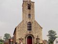
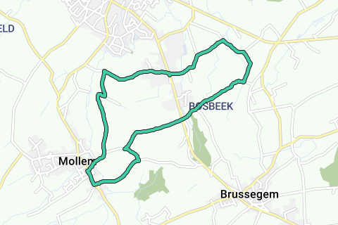
The walk starts at the church of Mollem. On the GPS you enter either Dorp or Kasteelstraat 21. On the square in front of the church and in the immediate vicinity you will find plenty of parking space. You leave to the left of the church where you pass an information board with explanations about the village of Mollem and the St. Stephen's Church. The former rectory is definitely worth a look. Follow the hiking signs Grote Molenbeekpad and Hellepad. Ignore the street to the left and walk to the end of the street, past the name sign of Brussegem. At the end of the Mollemstraat straight ahead. It goes up gently here with a water feature on your left. You turn left in the direction of cycle junction 19. From here you have a beautiful view of Mollem.
A little further you do not walk to the right, but you continue straight ahead and follow the Strijdlandstraat. You walk up on a road with left and right concrete slabs, separated by a green center strip with cobblestones. Slowly rising you walk between green coulters with wide views and a 360° panorama. You will pass the Potaerdehoeve on your left, a modern dairy farm. From here you descend slowly in the direction of the valley of the Great Molenbeek.
Follow the paved road in the right turn and ignore the forest path to the left. A little further you reach the next farm. Turn left here into the Ezelsweg. You now walk in the direction of Merchtem, which is dominated by the tower of the Onze-Lieve-Vrouw-ter-Noodtkerk. At the end of the Ezelsweg turn right into the Koeweidestraat. Here it is wonderful to walk between the Brabantse Kouters. It is hard to believe that you are barely ten kilometers from Brussels center. In the Koeweidehof, also a dairy farm, you can go during the season for the pride of Brabant: ground chicory. Through a number of companies you eventually reach the very busy Merchtem – Brussels road. Right in front of it, follow Dooren.
Where the road becomes a cobblestone road again, you go over the Kwetstenbeek. You walk again through a beautiful agricultural landscape. Follow this cobblestone road to café-restaurant Het Bos. Turn right into Potveld, direction cycle junction 58. At the end of Potveld turn right into Kleistraat, which you immediately leave by walking to the right of the farm. You now follow the Callaris hiking trail. You walk past footpath 40 and a little further, where the path makes a right-angled turn, you turn left. You will continue to follow the Callaris hiking trail. The narrow path runs between meadows where a striking number of horses are grazing. Follow this path to some farm buildings where you will again come to a paved road.
Turn right here and you still follow the Callaris hiking trail. The road again turns into an earth and gravel road. Here you walk at about 50 meters height with unique views over the Brabantse Kouters. In the distance you can see the hamlet of Bosbeek. At the crossroads, keep walking straight ahead, down the hollow concrete road, until you cross the Merchtem – Brussels track again. You leave the Callaris hiking trail and walk into the Olmenstraat. Soon you have beautiful views again. Continue to follow this road in the direction of the power line. When the road turns to the left, you reach the Spanjaardshof, an imposing farm with several farm buildings. Just past the Spanjaardshof, at the mollemstraat, turn left. After a few upward turns, turn right into the cobblestone road. This is part of the Great Molenbeek Hiking Trail. The road very quickly turns into an earth road. While descending you have a beautiful view of the village of Mollem. Back on the paved road, keep right (this is still the Great Molenbeek Hiking Trail). Keep following this road straight until the end. Turn right at the crossroads. Now continue your way to the church of Mollem.
Navigate route in...
![]() RouteYou app Open
RouteYou app Open
Don't want to see this ad anymore?
→ Upgrade now
![]()
Please wait, the navigation is being prepared.
You can now navigate. Have fun on the road!
Processing your request has failed. Please try again.
Don't want to see this ad anymore?
→ Upgrade now
![]()
Please wait, your download is being prepared.
Your download is ready. Have fun on the road!
Processing your request has failed. Please try again.
Don't want to see this ad anymore?
→ Upgrade now
![]()
Please wait, your print is being prepared.
Your print is ready to download. Have fun on the road!
Processing your request has failed. Please try again.
Don't want to see this ad anymore?
→ Upgrade now
![]()
Please wait, your download is being prepared.
Your download is ready. Have fun on the road!
Processing your request has failed. Please try again.
<iframe src="https://plugin.routeyou.com/routeviewer/free/?language=en&params.route.id=5029381" width="100%" height="600" frameborder="0" allowfullscreen></iframe>
<a href="https://www.routeyou.com/en-be/route/view/5029381/recreational-walking-route/uphill-downhill-through-the-brabantse-kouters?utm_source=embed&utm_medium=article&utm_campaign=routeshare" title="Uphill, downhill through the Brabantse Kouters - RouteYou" target="_blank"><img src="https://image.routeyou.com/embed/route/960x670/5029381-en@2x.png" width="960" height="670" alt="Uphill, downhill through the Brabantse Kouters"></a>
Additional feedback:
Try this feature for free with a RouteYou Plus trial subscription.
If you already have such an account, then log in now.
Try this feature for free with a RouteYou Premium trial subscription.
© 2006-2024 RouteYou - www.routeyou.com