A magnificent alpine tour to the Cabane des Dix with superb views over the Mont Blanc du Cheilon and it's surrounding glaciers. This includes a glacier walk as an extra Alpine experience.
Overview
The start of the hike is at the great dam of Lac des Dix. High up the valley of Val d'Herens lies the Grande Dixance dam, it's Europe's highest dam and looks very impressive when you drive to the parking area. Parking is free.
The first part in the guide is to climb to the top of the dam. You can take the lift but since you must leave early, it could be that it is not open yet. Once up the dam you'll leave immediately in the direction of Cabane des Dix. Since you'll have to do a lot of kilometers it's better that you walk on the dam when you return.
The first long part of the guide takes you along the lake of Lac des Dix from where you'll get very nice views on it's surrounding mountains. The paths are wide and flat but that will change once you've reached the end of the lake.
At the end of the lake you'll cross a small bridge and after that you'll leave the big path behind and start the climb to Cabane des Dix along Pas du Chat. There are no roadsigns and the path is not very clear, only bits of remnants of red paint. So take a good look at the GPS so that you are on the good track. The Pas du Chat is a tricky one to cross, it's small and you must climb a bit without chains. Be careful.
After Pas du Chat the path joins the white-red-white labeled path. A bit further, after crossing the water Torrent de Cheilon, you'll walk on a small ridge with a steady climb to the summit near Tête Noir. Once on top, you can see the Cabane des Dix but we advise you to walk to your left on a little higher summit with a cross. From there you'll have the best sight on Mont Blanc de Cheilon and the surrounding mountains.
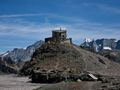
You'll descent to the Cabane in the valley of the glacier. The Cabane itself lies a bit higher on a rock. It's the best resting point with the best view you'll ever have. Take a breath and have diner here, the best has yet to come! From the Cabane you'll get a glimpse of the glacier crossing, can you see the "path"?
Once ready, you'll descent further and follow the sign to "Col du Riedmatten" - "Pas de Chevres" - Arolla. The path is indicated with red paint and red rocks. They will guide you over the debris fields and ice parts. The first debris field is relatively easy, after that you'll get your first path on ice followed by an other debris field and yet another icy part.
Getting out of the glacier pit is not so easy, big rock parts where you'll find your way through. So again, be careful and keep on the trail. Once out, you've survived the glacier crossing. Now it's a long descent to the lake, but when you think it would be so easy, you are wrong. Some debris fields, steep and craggy paths awaits you. That's why the descent does take a while, but you'll get amazing views in return.
At the end of the descent you cross the water Torrent de Cheilon again over a bridge before getting back on the big path along the lake. The return to the dam is the same as you'll did in the start of the day.
Hiking classification: T4 - Alpine hikes
Vertical up: 1106m
Vertical down: 1097m
Attention!
- This is a long hike, please start in time or stay a night at the Cabane
- The glacier crossing is ONLY for experienced hikers with some Alpine experience
- Glacier crossing with debris fields - paths are marked but not always good visible. Danger of falling. A good orientation is needed. Due to the decline of the glacier, the path changes each year, don't follow the GPS trails, only follow the red markings on the terrain!
- On the glacier, you'll need to cross several streams, some of them you'll need to look for safe passage or jump over them. Be cautious and don't fall! Several (inexperienced) people have lost their lifes by trying to cross the glacier.
- Wear good shoes (BC or C type).
- Do NOT do this hike with bad weather OR when there is snow on the glacier
Story
The great dam "La Grande Dixance" in Val d'Hérens. Always wanted to pay a visit again. I went here in 2007 with a friend of mine but didn't walk very far. So this year i prepared a little hike to the dam. The first part along the lake is quite long and since we had to ride 1,5h to get there i had two plans: either walk along the lake and return or try to reach the Cabane des Dix.
Just before i went on holiday i searched around a bit and found that the glacier of Cheilon could be crossed. Hmm would i do this? I penned it down on the map but forget to calculate the length of the hike...
So 10th august it was the day we went to the dam. The heights of Europe where the Eiffel tower fits just in. Amazing how they could build this. But anyway, let's start hiking ;-). As usual we didn't take the lifts to the top of the dam so we climbed to the top of the dam. Great gray lake. We didn't stop on the barrage and immediately left and took the trail to the end of the lake. It started great with some neat little tunnels. The path is big and relatively flat so it's very easy. Along the path the sight is beautiful.
Once we reached the end of the lake it was time to get to the first goal: Cabane des Dix. It wasn't very clear where the path started, the red paint was barely visible. The path i took was along Pas du Chat, not the whiteredwhite marked path that starts a bit further (but it does come together after Pas du Chat). Pas du Chat had a bit of dangerous very small path without chains (only some chains a bit higher).
From then it's climbing up and up the mountain along a small ridge along Torrent de Cheilon. But once you get on the heights point, the view is impressive! I got a tip to go to a little peak just above the col from where i would have a better sight and he was right.
The Cabane was finally visible, it lies a bit higher then the surrounding glacier and torrent. Finally some ascending to the cabane, but a small climb to get on the cabane. At this point i realized this hike would take longer then anticipated... I could return along the same route but i don't like that very much. A return over the glacier would be more fun so there i went to the glacier of Cheilon.
First part to the glacier was relatively easy but as you progress the path gets filled with more rocks. Eventually the path is one rocky way with some ice here and there. The glacier had two parts where there was just ice and no rocks, a bit slippery but doable. The sights from the glacier where tremendous!
Once crossed over i had to climb out of the glacier pit, a very rocky path and really searching for a way through it. I lost my balance and almost tumbled, i had luck to cary a walking stick to keep me up.
Once out of the glacier pit we get on the path to Pas de Chévres, but we do not go to the other valley (Arolla) but return to the Barrage. But once you thought that it would be a nice and steady descent, you thought wrong. It's one tough path to go back with debris fields, very steep and narrow paths. But what a view again. At the end you cross a bridge over the Torrent de Cheilon, what a power. After the bridge i got back at the lake, finally the hardest part was over. But still some 6km to the barrage. Damn, was i glad that i've reached the dam...
To put it all together, one tremendous great challenging hike! A bit too long but the views make it all good.
Tips:
- T4 Alpine hikes
- Long hike, so start early!
- Some dangerous parts, do not take any risks!
Navigate route in...
![]() RouteYou app Open
RouteYou app Open
Don't want to see this ad anymore?
→ Upgrade now
![]()
Please wait, the navigation is being prepared.
You can now navigate. Have fun on the road!
Processing your request has failed. Please try again.
Don't want to see this ad anymore?
→ Upgrade now
![]()
Please wait, your download is being prepared.
Your download is ready. Have fun on the road!
Processing your request has failed. Please try again.
Don't want to see this ad anymore?
→ Upgrade now
![]()
Please wait, your print is being prepared.
Your print is ready to download. Have fun on the road!
Processing your request has failed. Please try again.
Don't want to see this ad anymore?
→ Upgrade now
![]()
Please wait, your download is being prepared.
Your download is ready. Have fun on the road!
Processing your request has failed. Please try again.
<iframe src="https://plugin.routeyou.com/routeviewer/free/?language=en&params.route.id=2259976" width="100%" height="600" frameborder="0" allowfullscreen></iframe>
<a href="https://www.routeyou.com/en-ch/route/view/2259976/hiking-route/to-cabane-des-dix-and-glacier-de-cheilon?utm_source=embed&utm_medium=article&utm_campaign=routeshare" title="To Cabane des Dix and Glacier de Cheilon - RouteYou" target="_blank"><img src="https://image.routeyou.com/embed/route/960x670/2259976-en@2x.png" width="960" height="670" alt="To Cabane des Dix and Glacier de Cheilon"></a>
Additional feedback:
Try this feature for free with a RouteYou Plus trial subscription.
If you already have such an account, then log in now.
Try this feature for free with a RouteYou Premium trial subscription.
© 2006-2024 RouteYou - www.routeyou.com