Summary:
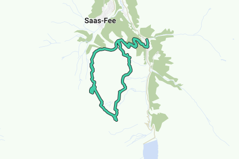
The route starts in Saas-Almagell and takes you around the Mittaghorn/egginer mountains. Main goal in this route is reaching the Brittanniahütte (3030m).
Route:
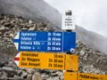
From Saas-Almagell you'll head to the bridge over the Saaser Vispa river and follow the yellow signs in the direction of "Gemsweg"/Plattjen. The paths is always climbing up with only brief moments where you can rest out on flatter pieces. Chances are big that you see here many Alpine ibexes. Once you reach "Plattjen Berghaus" at 2385m above sea level you follow the direction of "Plattjen" Bergstation (2570m) which isn't open in the summer period. From this point on, the path will get more rough and good stability and orientation is required; the alpine trail is already indicated on the roadsigns, so we follow this in the direction of "Felskin/Britanniahütte". The high trail leads you allong the eastern part of the Mittaghorn to the Meiggertal and further on along the Heidefridhof. Just after Heidefridhof the other trail that comes from Zermeigern joins our trail. On that point there is no direction indicators but we keep following our main trail. You're now entering the Alpine trail area when you get to the next intersection. At this point you can either shorten the route by going to Egginerjoch/Felskin, but then you don't get to the Britanniahütte. So we keep following the Britanniahütte.
Quickly you'll start walking through snow fields and eventually the Chessjengletcher glacier; the trail on the glacier here is, depending on what the weather was, clearly visible in the snow. Crampons can come in handy here, together with walking sticks so that you don't slip and slide. The hut is from that point already visible so set your target and go to the hut! The trail joins our departing trail for later just before the hut. It will also be indicating at the intersection if the alpine trail to Felskin is safe, after snowy weather in the Summer it can be closed due to risk of avalanches. Once arrived at the hut, enjoy the great view from the terrace and rest out with a good Rösti for dinner and some coke for extra sugar, you'll be needing it for the other big part of the route!
Time to head further, we follow the route from where you came from back to the intersection with the trail we just did. We keep on the high trail on the Chessjen glacier. The snow trail is very small along the steep slope, be very careful and when you cross other alpinists/hikers from the opposite direction, try to get a good stand in the snow so that they can pass safely. Along the trail is a section with rocks that you'll have to pass through, it requires much attention as the markings are not clear! The Blue/White alpine markings can take you up the mountain too! Try to orientate good here and remember that the path stays at almost the same level as you're walking now but you'll have to search a route through the rocks to get back onto the glacier. Once on the glacier the hardest part of the glacier is over and you'll go further along the small trail in the direction of Felskin/Egginerjoch.
Once you'll reach Egginerjoch it's time for the most difficult part. On the pole with the Alpine trail directions there is no option in the direction of Saas-Fee (Mast4), but that's where we are headed towards. So you can either give up by going to Felskin and take the lift back to Saas-Fee, or show that you are a true hiker by going for adventure...
What we do here is follow the path to the right in the direction Plattjen but after 150m you'll see on a big rock two directions painted (not clearly visible anymore), left to Saas-Fee, right to Plattjen (route where we came from). We take the left one in the direction of Saas-Fee/Mast4; it's a steep snow slope where we have to get down of, if the snow is soft it's easy to slide your way down but when it's hard, crampons are advised. Once you get off the snow field, you'll notice that there isn't any path visible. It can happen that you'll find a remnant of paint on a rock like i did and try to follow that but it quickly disappears again. A good map is advised and good orientation to get down safely. There is a winter cableway that can guide you down but you'll have to search for good rocks and make your own trail further down. Eventually you'll see Mast4 midstation where there is a visible path again, you'll be glad that you get safe at that point ;). Now that the hardest part is over we can safely hike further down in the direction of Saas-Fee/Plattjen where you'll get more amazing views over the glaciers and mountains around Saas-Fee and Saas-Fee itself. Once you near Plattjen choose the Gemsweg again to Saas-Almagell (this spares another climb to the Plattjen Bergstation. A bit further you'll get back on the path we used in the start of the hike, you'll notice that it's still a long and steep way down to Saas-Almagell
Hike difficulty: Up to T5 – Challenging Alpine Hikes (mainly because of the difficult part down from Egginerjoch, Brittaniahütte area and Chessjen glacier is T4)
Requirements:
Good hiking shoes, type C; walking sticks, crampons can come in handy too. Good hiking experience required, not afraid of heights, good orientation skills. Topo Schweis map and route map.
Only do this hike in favorable weather conditions, not in snowy conditions and with freezing level above 3500m. Take good note of the conditions before attempting this hike, ask in the hotel where you're staying or the tourisme bureau what the conditions are.
Hike summary:
Length: 22km
Climbing up: 1822m
Climbing down: 1826m
Time: 8h+
Navigate route in...
![]() RouteYou app Open
RouteYou app Open
Don't want to see this ad anymore?
→ Upgrade now
![]()
Please wait, the navigation is being prepared.
You can now navigate. Have fun on the road!
Processing your request has failed. Please try again.
Don't want to see this ad anymore?
→ Upgrade now
![]()
Please wait, your download is being prepared.
Your download is ready. Have fun on the road!
Processing your request has failed. Please try again.
Don't want to see this ad anymore?
→ Upgrade now
![]()
Please wait, your print is being prepared.
Your print is ready to download. Have fun on the road!
Processing your request has failed. Please try again.
Don't want to see this ad anymore?
→ Upgrade now
![]()
Please wait, your download is being prepared.
Your download is ready. Have fun on the road!
Processing your request has failed. Please try again.
<iframe src="https://plugin.routeyou.com/routeviewer/free/?language=en&params.route.id=2289324" width="100%" height="600" frameborder="0" allowfullscreen></iframe>
<a href="https://www.routeyou.com/en-ch/route/view/2289324/hiking-route/around-the-mittaghorn-egginer-to-the-britanniahutte?utm_source=embed&utm_medium=article&utm_campaign=routeshare" title="Around the Mittaghorn/Egginer to the Britanniahütte - RouteYou" target="_blank"><img src="https://image.routeyou.com/embed/route/960x670/2289324-en@2x.png" width="960" height="670" alt="Around the Mittaghorn/Egginer to the Britanniahütte"></a>
Additional feedback:
Try this feature for free with a RouteYou Plus trial subscription.
If you already have such an account, then log in now.
Try this feature for free with a RouteYou Premium trial subscription.
© 2006-2024 RouteYou - www.routeyou.com