Source: Flickr
Droits d'auteur: Creative Commons 2.0
31 vues | Publique
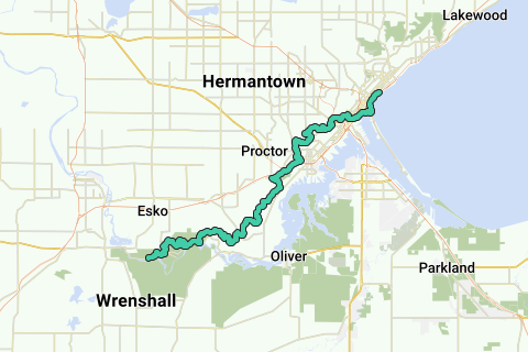
The Superior Hiking Trail, also known as The SHT, is a 275-mile (442 km) long footpath in Northeastern Minnesota that follows the ridgeline overlooking Lake Superior for most of its length. The path is 18-inches wide and is set in the middle of a 4 foot clearing. The footpath travels through forests of birch, aspen, pine, fir, and cedar. Hikers enjoy views of boreal forests, the Sawtooth Mountains, babbling brooks, rushing waterfalls, and abundant wildlife. The lowest point in the path is 602 feet (183 m) above sea level and the highest point is 1,829 feet (558 m) above sea level. The footpath is intended for hiking only. Motorized vehicles, mountain bikes, and horses are not allowed on the trail. Many people use the footpath for long distance hiking. Facilitating this purpose are 81 campsites spread throughout the northern section of the trail.
Inspired by OSM.
Parcourir l'itinéraire dans...
![]() Application RouteYou Ouvrez
Application RouteYou Ouvrez
Plus voir cette annonce?
→ Améliorez maintenant
![]()
Veuillez patienter, la navigation est en cours de préparation.
Vous pouvez maintenant naviguer. Amusez-vous en route!
Le traitement de votre requête a échoué. S'il vous plaît réessayez.
Plus voir cette annonce?
→ Améliorez maintenant
![]()
Veuillez patienter, votre téléchargement est en cours de préparation.
Votre téléchargement est prêt. Amusez-vous en route!
Le traitement de votre requête a échoué. S'il vous plaît réessayez.
Plus voir cette annonce?
→ Améliorez maintenant
![]()
Veuillez patienter, votre impression est en cours de préparation.
Votre impression est prête à être téléchargée. Amusez-vous en route!
Le traitement de votre requête a échoué. S'il vous plaît réessayez.
Plus voir cette annonce?
→ Améliorez maintenant
![]()
Veuillez patienter, votre téléchargement est en cours de préparation.
Votre téléchargement est prêt. Amusez-vous en route!
Le traitement de votre requête a échoué. S'il vous plaît réessayez.
<iframe src="https://plugin.routeyou.com/routeviewer/free/?language=fr&params.route.id=2057218&params.language=en" width="100%" height="600" frameborder="0" allowfullscreen></iframe>
<a href="https://www.routeyou.com/en-us/route/view/2057218/hiking-route/superior-hiking-trail?utm_source=embed&utm_medium=article&utm_campaign=routeshare" title="Superior Hiking Trail - RouteYou" target="_blank"><img src="https://image.routeyou.com/embed/route/960x670/2057218-en@2x.png" width="960" height="670" alt="Superior Hiking Trail"></a>
Commentaires supplémentaires:
Essayez cette fonctionnalité gratuitement avec un abonnement d'essai RouteYou Plus.
Si vous avez déjà un tel compte, connectez-vous maintenant.
Essayez cette fonctionnalité gratuitement avec un abonnement d'essai RouteYou Premium.
© 2006-2024 RouteYou - www.routeyou.com