Risorsa: Flickr
Diritti d'autore: Creative Commons 2.0
31 visite | Pubblica
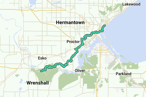
The Superior Hiking Trail, also known as The SHT, is a 275-mile (442 km) long footpath in Northeastern Minnesota that follows the ridgeline overlooking Lake Superior for most of its length. The path is 18-inches wide and is set in the middle of a 4 foot clearing. The footpath travels through forests of birch, aspen, pine, fir, and cedar. Hikers enjoy views of boreal forests, the Sawtooth Mountains, babbling brooks, rushing waterfalls, and abundant wildlife. The lowest point in the path is 602 feet (183 m) above sea level and the highest point is 1,829 feet (558 m) above sea level. The footpath is intended for hiking only. Motorized vehicles, mountain bikes, and horses are not allowed on the trail. Many people use the footpath for long distance hiking. Facilitating this purpose are 81 campsites spread throughout the northern section of the trail.
Inspired by OSM.
Naviga nel percorso in...
![]() App RouteYou Aprire
App RouteYou Aprire
Vuoi smettere di vedere questo annuncio?
→ Upgrade ora
![]()
Attendi, la navigazione è in preparazione.
Ora puoi navigare. Buon divertimento in viaggio!
Elaborazione della richiesta non è riuscita. Si prega di riprovare.
Vuoi smettere di vedere questo annuncio?
→ Upgrade ora
![]()
Attendi, il tuo download è in preparazione.
Il tuo download è pronto. Buon divertimento in viaggio!
Elaborazione della richiesta non è riuscita. Si prega di riprovare.
Vuoi smettere di vedere questo annuncio?
→ Upgrade ora
![]()
Attendi, la tua stampa è in preparazione.
La tua stampa è pronta per il download. Buon divertimento in viaggio!
Elaborazione della richiesta non è riuscita. Si prega di riprovare.
Vuoi smettere di vedere questo annuncio?
→ Upgrade ora
![]()
Attendi, il tuo download è in preparazione.
Il tuo download è pronto. Buon divertimento in viaggio!
Elaborazione della richiesta non è riuscita. Si prega di riprovare.
<iframe src="https://plugin.routeyou.com/routeviewer/free/?language=it&params.route.id=2057218&params.language=en" width="100%" height="600" frameborder="0" allowfullscreen></iframe>
<a href="https://www.routeyou.com/en-us/route/view/2057218/hiking-route/superior-hiking-trail?utm_source=embed&utm_medium=article&utm_campaign=routeshare" title="Superior Hiking Trail - RouteYou" target="_blank"><img src="https://image.routeyou.com/embed/route/960x670/2057218-en@2x.png" width="960" height="670" alt="Superior Hiking Trail"></a>
Altri commenti:
Prova questa funzionalità gratuitamente con un abbonamento di prova RouteYou Plus.
Se hai già un tale account, accedi ora.
Prova questa funzionalità gratuitamente con un abbonamento di prova RouteYou Premium.
© 2006-2024 RouteYou - www.routeyou.com