7568 views | Public | Dutch
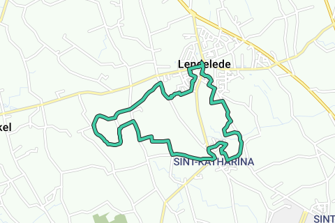
Distance : 9,5km - Short route: 7,5 km
Paving: alternating paved and unpaved surface.
Start: Church Dorpsplein, Lendelede (or church Sint-Katrienplein, Sint-Katharina)
Public transport: bus no.60 Roeselare – Izegem – Lendelede – Kortrijk (limited service during the weekend)
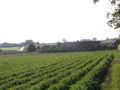
Lendelede has always remained a rural municipality and still has a lot of open space. The center is located on a ridge that separates the Mandel Basin from the Lys Basin. From the south side there are beautiful views. At the time of the world wars, one could see the spectacle of the bombing of the city of Kortrijk from the Lendeleed height. And even now there is a good overview of the city at the bottom of the Lys. Moreover, from here one can see the Kluisberg, Hoog Kortrijk (Kooigembos, Argendaalbos). And on a clear evening or night you can even see the light pole of the Catsberg.
1) Start : We start at the Village Square in Lendelede where there is plenty of parking.
The St. Blaise's Church is a late Gothic church from the early 16th century with early Gothic tower 13-14th century and neo-Gothic additions and repairs from the 19th and 20th centuries. The tower was used as a lookout during the 2nd world war. Take the Winkelsestraat in the direction of Sint-Eloois-Winkel. We pass the fire station. About 50 meters further on the side of the fire station we turn into the Steckenbornpad between house numbers 23 and 25. Follow the path for about 200m until the path turns into an asphalt road.
2) At that transition (where there is a red bench and trash can), turn immediately to the right. This way you get into a piece of street (Hoog Einde). Walk straight for about 50m until you end up on a hiking trail. Turn right at the end. At the next branch (in the case of a triangular bunch of plants), turn left again. At the end you turn diagonally left to get to a new asphalt road (De Knok).
Cross the Langemuntelaan diagonally right to Rodemont.
3) After about 100m we take the walking path on the left between house numbers 11 and 13. At the electricity pylon turn right along the Dackemaertspad. Follow the earthen wegel. At the end of this path, turn right along Kortrijksestraat.
This would possibly be the oldest road from Lendelede on the Roman connection between Kortrijk and Oudenburg.
4) Between house numbers 49 and 53 we turn left. This is the Beiaardlindeweg, in the popular road the "Zandstraete". It takes us to the original highest point of the municipality near the Carillon Lime. The asphalt road turns into an earthen and semi-paved road. Once at the top you will arrive at the Beiaardstraat.
Here were some houses where, according to some sources, the infamous Ludovic Baekelandt was born.
Fork: If you want to see the carillon lime, with the view over the Leiedal and beyond, go 50 meters to the left. Those who want the shorter walk do the same. Those who take the longer walk go diagonally straight ahead and take the Sint-Antoniusstraat.
Follow Sint-Antoniusstraat. Near the 'district' Piepe, turn left into the aardewegel next to house number 7.
If you want, you can first go straight on for 200m to the St. Anthony's Chapel from the 19th century. This was best known as a place of pilgrimage for unmarried women looking for a life partner.
5) The earth road ends at the Stevenistenhoek/Stevenistenwegel.
This district was inhabited in the early 19th century by a group of Stevenists. That was a sect that had separated from the Catholic Church (they did not agree with the concordat of 1801) and performed the divine services at home.
At the height of the chapel of "De Heiligen" (Claerbout's chapel) you turn into the narrow earth road to the right. You end up in the Beiaardstraat a 100m from the Beiaardlinde.
From here you also have the panorama of the Leiedal and the surroundings behind it. You can see the Kluisberg, the forests of Kooigem and Argendaal, closer you can also see the Heulebos and the Steenbeekbos on the right. Turn right and descend along Beiaardstraat. Turn left, along the driveway of the Aerdgoed.
6) In front of the farm, the wegel turns to the right. Keep following this road around the farm. Turn right to enter Sentestraat. Turn left into Sentestraat and walk towards the church of Sente. At the end, turn left onto Sint-Katharinastraat. At the intersection, cross the street to Sint-Katrienplein.
7) You can leave from Sint-Katrienplein in Sente. Then turn left. Walk along the Heulsestraat. Turn right into Burgemeester G. Dussartlaan. On the left you can find the Hazebeek. (at the end of each side street) with the Partridge Forest and dump behind it. Walk straight on to the end of the avenue. Turn right behind the last house.
8) After you end up back in a first side street of the G. Dussartlaan, cross the canal and cross the grass square. This is how you end up in Waubrechts. If you go straight ahead, you will end up in the Sint-Katriensteenweg. Turn left. Before the railway you turn left again in the Lendeleedsestraat. This will be the Kuurnsestraat.
Turn left into the Partridge Forest. The entrance is indicated by a totem pole and an information board. Turn the first path to the left. Stay tuned. When you come back to the main axis, go diagonally straight ahead. Pass the insect hotel and the pond through the orchard next to Hoeve Vercaemer.
Hoeve Vercaemer is a collaborative project between the municipality of Lendelede and vzw Buurt Initiatieven Kuurne (BIK)
9) Turn right so that you end up back in the Kuurnsestraat. Turn left and walk further up. A few meters before you are at the top there is a grass road to the left. This leads to the Mountain Chapel.
The Mountain Chapel or Fever Chapel is dedicated to Our Lady of the 7 contractions and originally dates from the 17th century. It was a well-known place of pilgrimage.
On the other side of the fence is the Lendelede landfill. This was initially a clay mining area. Between 1982 and 2011 it was dumped here.
Pass by the mountain chapel. At the end you will end up in the Kuurnsestraat again. Turn left. Take the first street to the right (Dahliastraat).
10) Then turn left into Violierstraat. Walk straight ahead. This becomes the monastery garden that turns into a narrow path. Once you are in the Heulsestraat, turn right and walk back to the starting point at the church. There are several possibilities for a snack and a drink.
This walk was made by: Kurt Meerschaert
Photos: Kurt Meerschaert
This walk previously appeared in Ivy, volume 26 no. 1.
Ivy is the member magazine of Natuur.koepel vzw. More info: http://www.natuurkoepel.be
Navigate route in...
![]() RouteYou app Open
RouteYou app Open
Don't want to see this ad anymore?
→ Upgrade now
![]()
Please wait, the navigation is being prepared.
You can now navigate. Have fun on the road!
Processing your request has failed. Please try again.
Don't want to see this ad anymore?
→ Upgrade now
![]()
Please wait, your download is being prepared.
Your download is ready. Have fun on the road!
Processing your request has failed. Please try again.
Don't want to see this ad anymore?
→ Upgrade now
![]()
Please wait, your print is being prepared.
Your print is ready to download. Have fun on the road!
Processing your request has failed. Please try again.
Don't want to see this ad anymore?
→ Upgrade now
![]()
Please wait, your download is being prepared.
Your download is ready. Have fun on the road!
Processing your request has failed. Please try again.
<iframe src="https://plugin.routeyou.com/routeviewer/free/?language=en&params.route.id=4515372" width="100%" height="600" frameborder="0" allowfullscreen></iframe>
<a href="https://www.routeyou.com/en-be/route/view/4515372/walking-route/along-the-rugge-of-lendelede?utm_source=embed&utm_medium=article&utm_campaign=routeshare" title="Along the Rugge of Lendelede - RouteYou" target="_blank"><img src="https://image.routeyou.com/embed/route/960x670/4515372-en@2x.png" width="960" height="670" alt="Along the Rugge of Lendelede"></a>
Additional feedback:
Try this feature for free with a RouteYou Plus trial subscription.
If you already have such an account, then log in now.
Try this feature for free with a RouteYou Premium trial subscription.
© 2006-2024 RouteYou - www.routeyou.com