722 views | Public | Dutch
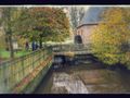
A long journey of 18 km over forest and heathland in Retie in Antwerp. Princely Retie, because you walk through a large part of the Provincial Domain Prinsenpark, formerly part of a vast heathland, where the farmers grazed their sheep and used the top layer or 'heath patches' as a litter layer for the stables. Now it is a 215-hectare nature reserve, where you can view the many ducks, swans and other aquatic inhabitants in an observation hut on the Hooibeek. In the visitor center you can look for more information about this domain and its fauna and flora.
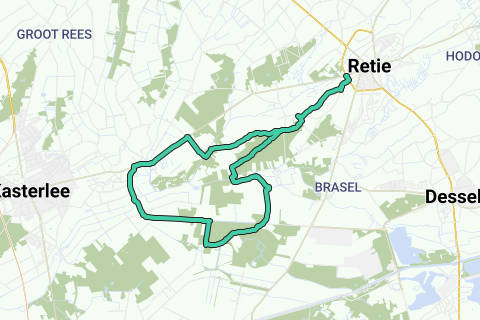
1. Park at the Holiday Centre De Linde (V) in the Kasteelstraat along the N123 Retie-Kasterlee. Walk next to De Linde into Sint-Paulusstraat and immediately take right Sint-Pieterstraat, past the beautiful chapel. It becomes Geenend and at the Geenendhof you walk right onto the GR path. On the right you see Castle Lust for Life. At the quadrangle straight ahead, along with the GR that you also continue to follow at a rest bench, so straight ahead. At the Tiliahoeve you cross the asphalt road, past the chapel (1) to the left and then right again with the walking signs. You now follow a forest path and come to a quadrangle with resting bench. Turn right and at the asphalt just right and immediately sharp left onto the asphalt of the Kleineduinberg. It will be an equally wide, rural gravel-dirt road that you follow a long way over the Beverdonk heath. At the intersection with 't Landhuis, a bivouac house with picnic area, turn right into Beverdonk and over the wide earth road through the Westreties.
2. You come back to an asphalt road. Beware of car traffic. Fortunately, you can go behind the row of trees on the other side on the bike path. Ahead: turn left, later over the Wamp and just before the Beermolen van Terlo (2) turn left. The mill dates from 1801 and served as a grain and bark mill until 1957. The upper crawler is now used as a private residence. So you follow the Desselsebaan, cross the Kleine Nete, walk straight ahead at cycle junction 26 and finally turn left. Where the concrete road becomes a sandy path, there is a robust concrete block on the right in the meadow. This is the Western terminal post (3) of the Geodesic base of the Kempen. Once a straight stretch of road left here, the length of which was precisely known. This used to serve to derive correct distances when drawing up the first geographical maps in our country. Current technology makes the reference route superfluous, but the path is still there. We'll follow that for a while. Continue straight past Kastelsedijk and at the fork. You also pass Bosheide, here is also a paved cycle path.
3. Continue straight on at the sign Provincial Domain Prinsenpark on the paved cycle path and only at the cycle junction 25 turn right into the domain along the edge of the forest. At the T with picnic bench you walk into the path to the left. You pass a pond with another picnic bench and just go straight ahead at the intersection of roads. You now walk along a larger lake, the Hooibeek, with a bird watching hut (4). Ideal for watching the many ducks, swans and other water birds. Keep following the path along that lake, past another viewpoint with picnic benches, over a stream and straight on until you reach the main building of the Provincial Domain Prinsenpark (5). Pay attention to the information board about the Kempense Heuvelrug hiking network, immediately a tip for a next walk.
4. Walk left through the main entrance into the parking lot and follow the sandy path to the left of the parking lot. Via a piece of cycle path straight ahead in the direction of cycle junction 93. This way you step onto a wide, tree-lined paved road between the fields. At the end of it you turn to the right and a little further you choose the first path on the left. About 1 km further you turn right and ignore the dead end road on the left. You cross the Kleine Nete and follow to the right again. Turn left and turn right again at the Maria chapel (6). A little further on you step straight into the forest at the crossroads, between the weekend houses. At the crossroads go straight ahead - so not in the direction of hiking junction 95 - and ignore all side roads to the edge of the forest. We have seen this place on the way there, the end is in sight. Turn right and from here you walk the same road from earlier in the day back to De Linde. So turn right at the asphalt and immediately left again. At the rest bench turn left and left again at walking guide 139. At the T-junction turn right past 'the old plough', at the Tiliahoeve turn left and at the next bench turn left with the GR path. Finally turn left again and via the asphalt of the Sint-Pieterstraat to De Linde. Well done, you have 18 km in the legs!
Navigate route in...
![]() RouteYou app Open
RouteYou app Open
Don't want to see this ad anymore?
→ Upgrade now
![]()
Please wait, the navigation is being prepared.
You can now navigate. Have fun on the road!
Processing your request has failed. Please try again.
Don't want to see this ad anymore?
→ Upgrade now
![]()
Please wait, your download is being prepared.
Your download is ready. Have fun on the road!
Processing your request has failed. Please try again.
Don't want to see this ad anymore?
→ Upgrade now
![]()
Please wait, your print is being prepared.
Your print is ready to download. Have fun on the road!
Processing your request has failed. Please try again.
Don't want to see this ad anymore?
→ Upgrade now
![]()
Please wait, your download is being prepared.
Your download is ready. Have fun on the road!
Processing your request has failed. Please try again.
<iframe src="https://plugin.routeyou.com/routeviewer/free/?language=en&params.route.id=5295249" width="100%" height="600" frameborder="0" allowfullscreen></iframe>
<a href="https://www.routeyou.com/en-be/route/view/5295249/recreational-walking-route/princely-retie?utm_source=embed&utm_medium=article&utm_campaign=routeshare" title="Princely Retie - RouteYou" target="_blank"><img src="https://image.routeyou.com/embed/route/960x670/5295249-en@2x.png" width="960" height="670" alt="Princely Retie"></a>
Additional feedback:
Try this feature for free with a RouteYou Plus trial subscription.
If you already have such an account, then log in now.
Try this feature for free with a RouteYou Premium trial subscription.
© 2006-2024 RouteYou - www.routeyou.com