2080 views | Public | Dutch
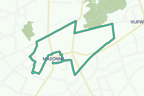
Appointment at the church of Madonna (V), a hamlet of Langemark-Poelkapelle that made a name for itself in 2011 through the film The Pig of Madonna. In front of the church, the image of the seasonal worker with a balloon over his shoulder reminds of the seasonal workers who went from here to France until 1964 to cut beets. With the church on your left you start. Step opposite Vrije Basisschool 't Madointje on the left into the Kerkstraat. Walk past the cemetery, ignore a street on the right and, where the road turns left, turn right. The street turns into a narrow church path between fields and meadows. Ignore a church path on the left, cross a narrow asphalt road and continue to the T. Follow the wider field road to the right and enter the fields at the intersection with an old railway bed Ypres-Kortemark. Turn left, along with the blue arrow, on a red bike path between the fields. Cross the Houthulstseweg and continue to follow the cycle path, towards junction 51 of the Westhoek cycling network. You step past the former station 1 of Poelkapelle and an idyllic pond 2. At a conservatory you leave the Bareelstraat on the right and cross the Stadensteenweg. 500 m further you come to a crossroads with an unpaved field road. Turning left would be nice, but a sign forbids the passage. So we were forced to continue until the next quadruple. Turn left here and continue walking on a narrow asphalt road, past a farm and a spacious building, until the next intersection. Right in front of you are the forests of Houthulst and the Vrijbos, known from the comic series Bakelandt, but the real gang of the same name has also been hiding there. 150 years ago Madonna was called 'Langemarcksche Boschkant' and was located in the Vrijbos. The forest was destroyed during WWI and during WW II what remained was used as fuel. Walk left into Conterdreef. On the left you see the private road between the fields that you were not allowed to take, on the right a fenced military domain 3 and in the distance the church of Madonna. Slow roads are beautiful, but often end up on a busy road. This is also the case now and you are forced to follow the N301 to the right. No laughing matter, because there is no cycle path and the roadside is narrow. You walk past a farm and again along the military domain and after 500 m you turn left into the Pottestraat. Now you walk again on a quiet road between fields and meadows. After just over 1 km you cross an intersection. Continue (still in the Pottestraat) and turn left past the first farm into the wide field road. Turn right with the road between the fields and you will end up on another field road. Follow it straight on to civilization. At the first intersection you walk straight ahead and opposite house no. 36 you take a church path on the left. There are several signposted routes along it. At the end of the path you dive into a green tunnel. When you get out, you cross an asphalt road, ignore a street on the left and, opposite house No. 34, turn right into another beautiful church path. At the end, follow Galgestraat to the left. Where it turns right, towards café Te Lande 4, go straight ahead and make a left-right nod. It continues on a rough field road and on the T you turn left towards houses. The field road turns into a wide strip of grass. Cross the street and continue walking along the field road. On the right is the church of Madonna. Every hour five bells play the Lourdes song. Bend with the road to the right and continue until you reach the Klerkenstraat. Turn left and then the first field road on the right. You walk behind a football field and turn right at the first quadruple jump. At the end turn left and then, next to the house no. 219, turn right into a narrow church road. This takes you to the church path that you walked on at the beginning of the walk. Turn right until you reach the church.
Navigate route in...
![]() RouteYou app Open
RouteYou app Open
Don't want to see this ad anymore?
→ Upgrade now
![]()
Please wait, the navigation is being prepared.
You can now navigate. Have fun on the road!
Processing your request has failed. Please try again.
Don't want to see this ad anymore?
→ Upgrade now
![]()
Please wait, your download is being prepared.
Your download is ready. Have fun on the road!
Processing your request has failed. Please try again.
Don't want to see this ad anymore?
→ Upgrade now
![]()
Please wait, your print is being prepared.
Your print is ready to download. Have fun on the road!
Processing your request has failed. Please try again.
Don't want to see this ad anymore?
→ Upgrade now
![]()
Please wait, your download is being prepared.
Your download is ready. Have fun on the road!
Processing your request has failed. Please try again.
<iframe src="https://plugin.routeyou.com/routeviewer/free/?language=en&params.route.id=5342960" width="100%" height="600" frameborder="0" allowfullscreen></iframe>
<a href="https://www.routeyou.com/en-be/route/view/5342960/recreational-walking-route/slow-roads-around-madonna?utm_source=embed&utm_medium=article&utm_campaign=routeshare" title="Slow roads around Madonna - RouteYou" target="_blank"><img src="https://image.routeyou.com/embed/route/960x670/5342960-en@2x.png" width="960" height="670" alt="Slow roads around Madonna"></a>
Additional feedback:
Try this feature for free with a RouteYou Plus trial subscription.
If you already have such an account, then log in now.
Try this feature for free with a RouteYou Premium trial subscription.
© 2006-2024 RouteYou - www.routeyou.com