Source: Paul Hermans
Copyright: Creative Commons 4.0
5742 views | Public | Dutch
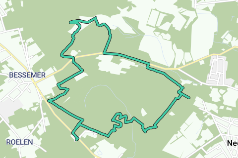
The Hoge Kempen National Park is a unique nature reserve with more than 5,000 hectares of forest and heathland. With a height between 50 and 100 meters, this is the highest part of the Kempen. The marked walks, to which we often refer here, are clearly marked on small poles. • Start at the parking lot opposite the petting zoo annex cafeteria of the Pietersheim domain (V) towards the stone wall. On the wall, turn right onto a plank path, starting point of walks. At the end turn left through the 'entrance gate', along the meadow edge. Once in the forest, turn right (signs blue/yellow/green). On a wider forest road turn right and immediately left again until a crossroads of paths. Turn left and follow the green signs. After 200 meters turn right on a narrow path (green) that widens further on. Turn left at the T-junction (signs blue/red/green). • Cross a stream and you'll reach a five-jump. Continue diagonally to the right (continue to follow signs). Then you come to the Pietersembos (1) with some solid relief and quick path changes. After a short ascent you turn right, you continue along the edge of the slope until you pass a birch forest, where you turn diagonally left; ignore side paths and intersections until you can turn right after a short drop at a T and turn left again after 100 meters. 200 meters further you leave green and follow the yellow and red signs on the right. • You will pass the hospital Campus Sint-Barbara (2). Here the walk can be shortened by 1.5 km: then you start at the parking opposite the campus (3). A few hundred meters past the campus at a crossroads of wider forest paths, keep turning right, following yellow and red. At the next second intersection, turn left onto a narrower path and ignore further side roads past a house. Turn right past a barrier. Attention: beyond a fence the path narrows; A little further on you turn left (always follow yellow / red). At the edge of a meadow turn right, you go away from the meadow and ignore side roads. • You come to a beautiful moorland with fence, here is a viewpoint with bench. At the end of the heath, where the path turns to the left, leave yellow and follow blue and red. After 400 meters straight ahead (green signs). At the reception centre for asylum seekers Ter Dennen (4) cross the Molenbergstraat and turn left (past the barrier). • Where green goes to the left, follow straight ahead again blue and red. After 400 meters just left / right. You enter the reserve of the Ziepbeek with moist heath (5). Further on sharp turn right. 600 meters after the bend leave red and follow a narrow path (blue and yellow) on the right. Nice passage partly on a plank path. At the T you turn left on a wider forest road. Keep following the signs until you reach Molenbergstraat again – cross and turn left (without signs) for 1 km following the nicely separated cycle path (attention: cyclists in two directions). You will pass the Molenberg Centre for childcare (6) and follow the yellow/red signs again. 400 meters further turn right on a narrow forest path over a small wooden bridge. • Turn left (leave red) and continue to follow blue/yellow/green. At the Yjunction follow the right branch (post with signs on the right hidden behind bushes). Ignore side roads and take the boardwalk opposite the pond. At the fork of paths you do not go towards the gate, but turn right on a narrow path. Turn left further on. Turn right at the intersection opposite a gate. Next intersection straight ahead. Turn right at the T-junction. • After about a hundred meters, at the end of the Beukendreef (7), leave green and follow yellow and blue on the left. After a few hundred meters turn right and almost immediately left. Keep following the main path. At a crossroads of paths, where greenery goes straight ahead, turn left and come again to the approach route, which you now follow in the opposite direction. At the T, just before the meadow, follow the brown crosses to the left until you reach the parking lot again. You can take a short walk through the domain to the Moated Castle.
Navigate route in...
![]() RouteYou app Open
RouteYou app Open
Don't want to see this ad anymore?
→ Upgrade now
![]()
Please wait, the navigation is being prepared.
You can now navigate. Have fun on the road!
Processing your request has failed. Please try again.
Don't want to see this ad anymore?
→ Upgrade now
![]()
Please wait, your download is being prepared.
Your download is ready. Have fun on the road!
Processing your request has failed. Please try again.
Don't want to see this ad anymore?
→ Upgrade now
![]()
Please wait, your print is being prepared.
Your print is ready to download. Have fun on the road!
Processing your request has failed. Please try again.
Don't want to see this ad anymore?
→ Upgrade now
![]()
Please wait, your download is being prepared.
Your download is ready. Have fun on the road!
Processing your request has failed. Please try again.
<iframe src="https://plugin.routeyou.com/routeviewer/free/?language=en&params.route.id=5367086" width="100%" height="600" frameborder="0" allowfullscreen></iframe>
<a href="https://www.routeyou.com/en-be/route/view/5367086/recreational-walking-route/through-the-hoge-kempen-national-park?utm_source=embed&utm_medium=article&utm_campaign=routeshare" title="Through the Hoge Kempen National Park - RouteYou" target="_blank"><img src="https://image.routeyou.com/embed/route/960x670/5367086-en@2x.png" width="960" height="670" alt="Through the Hoge Kempen National Park"></a>
Additional feedback:
Try this feature for free with a RouteYou Plus trial subscription.
If you already have such an account, then log in now.
Try this feature for free with a RouteYou Premium trial subscription.
© 2006-2024 RouteYou - www.routeyou.com