482 views | Public | Dutch
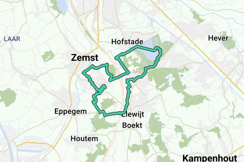
Round the weather along historic sites and roads over a loop length of 10Miles (16.09km).
This green loop departs from Ons Huis (HQ KWB Weerde on the Kostervoetweg, 100m from the Church of Weerde and café 't Schoonzicht (ample parking space at the church) which takes you in a counter-hour direction along Elewijt and the Blosodomein Hofstade. Of course you can start at any other point on the loop.
The loop is drawn along mainly historical roads and sights (enlarge the map and click on the POIs in the map for additional explanation): including the remains of Weerdemolen on the best preserved Zennemeanders above Brussels (watermill destroyed in WWI, only the toll house remains); the Rubens Castle and the Steenmolen along the Barebeekmeander (closed by the E19); Diependael Castle (currently a privately owned restaurant); the Bloso domain with the boat restaurant, the war memorial and the listed bathhouse; the last remaining pedestrian bridge that served as a slow road over the Senne between Hofstade and Weerde; the large Hofstade and Weerde ponds that were created by sand extraction for the Weerde-Muizen-Mechelen rail connection and the E19.
In Elewijt, the part between the Barebeek and the Tervuursesteenweg is cut (Waversebaan and Heirbaan), where almost 2000 years ago the Roman stone road ran between Tienen and Asse (on the Tongeren-Bonen connection, see http://www.dezemstenaar.com/ARCHIEF/zemstenaar%2052%20-%20april.pdf page 7, http://nl.wikipedia.org/wiki/Heirbaan_Tongeren-Bonen, http://nl.wikipedia.org/wiki/Via_Belgica, http://www.megalitica.be/halvestn/banen.htm), and where there are several remains of a Gallo-Roman settlement were found. In the period when the Senne regularly flooded the entire area of Weerde (a 'weerde' is a sandy elevation in swamp or flood area along a watercourse), there was already a Gallo-Roman activity in this part of Elewijt on this right bank of the Barebeek (just east of the Senne basin).
Also read the group information 'Weerde' for additional references and facts.
This loop is seasoned with various rural panoramas, field areas, trousers (Vriezenbroek between Blosodomein and E19, swamp zone along the Bossenhoek south of the Senne diversion), and several footpaths in Weerdse and in Elewijt.
In summary: A historically interesting, varied and quietly walkable 16.1km loop for hikers (including various options for a drink and a snack, see the POIs); a well-walkable and quiet 10miles loop for runners; A flat effe-to-rest-recreational rural cycling loop with or without the family.
The only weak point is the crossing from east to west on the E19 when returning: watch out for car traffic entering or leaving the E19!
Info to the people outside Zemst: In hot summer weather, the passage through the classified bathhouse in the Bloso domain (see POIs) is paid (safety considerations after hoopla with Brussels youngsters). If you start this loop in hot summer weather and want to skip this paying part, do not take the pedestrian bridge on the left over the large canal in the Bloso domain, but continue to follow this canal on your left until the end. You can then connect back behind the Sportimonium with the mapped loop.
Navigate route in...
![]() RouteYou app Open
RouteYou app Open
Don't want to see this ad anymore?
→ Upgrade now
![]()
Please wait, the navigation is being prepared.
You can now navigate. Have fun on the road!
Processing your request has failed. Please try again.
Don't want to see this ad anymore?
→ Upgrade now
![]()
Please wait, your download is being prepared.
Your download is ready. Have fun on the road!
Processing your request has failed. Please try again.
Don't want to see this ad anymore?
→ Upgrade now
![]()
Please wait, your print is being prepared.
Your print is ready to download. Have fun on the road!
Processing your request has failed. Please try again.
Don't want to see this ad anymore?
→ Upgrade now
![]()
Please wait, your download is being prepared.
Your download is ready. Have fun on the road!
Processing your request has failed. Please try again.
<iframe src="https://plugin.routeyou.com/routeviewer/free/?language=en&params.route.id=579133" width="100%" height="600" frameborder="0" allowfullscreen></iframe>
<a href="https://www.routeyou.com/en-be/route/view/579133/jogging-route/weerde-10mi-elewijt-hofstade-16-09km?utm_source=embed&utm_medium=article&utm_campaign=routeshare" title="Weerde 10Mi Elewijt-Hofstade (16,09km) - RouteYou" target="_blank"><img src="https://image.routeyou.com/embed/route/960x670/579133-en@2x.png" width="960" height="670" alt="Weerde 10Mi Elewijt-Hofstade (16,09km)"></a>
Additional feedback:
Try this feature for free with a RouteYou Plus trial subscription.
If you already have such an account, then log in now.
Try this feature for free with a RouteYou Premium trial subscription.
© 2006-2024 RouteYou - www.routeyou.com