11670 views | Public | Dutch
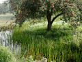
A route that runs along lakes, through meadows and along the river Vecht. The views are wide everywhere, and you can take a break in idyllic spots. From the starting point at the beach pavilion on the Maarsseveense Plassen you can also skate a lap around the Plassen of about five kilometers. The cycle path is very suitable for this.
If you come by car, take the Maarssen exit from the A27 or A2 to the N230. Get off the N230 at the Maarsseveense Plassen exit.
If you have reached the N230 from the A2, the exit will automatically lead you over the N230. After a few hundred meters you turn left to the Herenweg. Here you take the first right: the Maarsseveensevaart. Again, take the first exit on the right. You are now on the Oudedijk. After about 800 meters you can enter a large parking lot on the right. This is the starting point of the route.
Coming from the A27, turn right at the top of the exit. Then turn left onto Herenweg, from here the route is the same as from the A2
The parking lot at the Beach Pavilion is located on the Westbroekse Binnenweg, next to house number 2a in Maarssen. If you are using a navigation system, enter the place name Tienhoven.
If you travel by public transport, take city bus 10 to De Kwakel at Utrecht-Zuilen station, and from there city bus 122 to Westbroekse Binnenweg in Tienhoven. The route starts from the parking lot next to house number 2a.
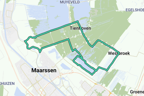
Start Skateroute Maarsseveense Plassen
1. A cycle path runs in front of the Strandpviljoen. Take this cycle path to the left: the Elzenpad. Where the cycle path bends to the right after 2 kilometers to follow the Plassen, turn left to the Westbroekse Binnenweg. Here to the right about nasty vowels. This is a bit of a bite over about 700 meters. At the end, turn left onto the cycle path that runs along the Burgemeester Huydecooperweg in the direction of Westbroek.
2. The 3 kilometer long bike path runs along the left side of the road, so watch out for oncoming traffic. The asphalt is nice and smooth up to the built-up area of Westbroek. From there, vowels follow over a few hundred meters. Follow the road with the bend to the left, as soon as you leave the village the asphalt is fine again.
3. There follows a stretch of about 2 kilometers where you regularly have beautiful views of nature just behind the houses and farms on your right. About 200 meters after the church is the Bert Bos Pad on the right. On this path you can make a beautiful walk of about 2 hours over peatlands, past reed beds and ditches as an extra trip.
4. After 2 kilometers, follow the Kerkdijk with the bend to the left. A little further on, the main road (Heuvellaan) bends to the right, towards Oud-Maarsseveen. The Heuvellaan becomes the Looijdijk, and even later into the Laan van Niftarlake. About 2 km after you have turned right you will arrive in Tienhoven.
If you want to get off for a cup of coffee or lunch on the way, you can do so here. In Tienhoven is Grand Café Het Olde Regthuys, open from 12.o'clock. On the terrace you have a great view of the surroundings. Closing days: Monday and Thursday.
5. A few hundred meters after the Olde Regthuys, the road bends to the left and becomes Nieuweweg here. Soon the bike path (two directions!) starts here on the left side of the road. The pavement is fair to good. Halfway you will see the entrance to recreation area De Strook on the right side of the road.
Recreation area De Strook consists of a beach and sunbathing areas along the south side of the Loosdrechtse Plassen (the Fifth Lake). In good weather it is good to stay here. The Pavilion (snack bar and pancake restaurant) is open for breakfast, lunch and dinner. From April to September from 07:00 to 22:00, from October to March from 09:00 to 17:00.
6. After about 3.5 km you will pass Fort Tienhoven, part of the New Dutch Water Line. The fort was built between 1848 and 1850 and served to close the Tienhovense Vaart and to guard the quay and locks. Fort Tienhoven is not open to the public.
7. The Nieuweweg ends at the Zandpad, where you turn left. On your right you will see the river Vecht. You continue to follow the water until you reach the built-up area of Maarssen after 1.8 km. Here you turn sharply left to the Machinekade. Halfway through it turns into the Middenweg. You drive through rural areas here, and the asphalt is good.
8. After 2.5 km turn right onto the Landweg, which automatically leads to the Maarsseveensevaart. Here you turn left (first cross!) and after 200 meters turn right again to the Oudedijk. This road is paved with pavers, so not ideal for skaters. Fortunately, after about 800 meters you are already at the parking lot of the Beach Pavilion.
9. Extra: Just before the entrance, the cycle path where the route started runs to both sides. Go to the right here. This cycle path runs all the way around the Maarsseveense Plassen and is about 5 kilometers long. The asphalt is very good, and you look out over the water in many places. Other stretches lead through a beautiful wooded area. The wooden bridges can be slippery in humid weather.
10. After 1.2 km of skating you will arrive at the parking lot on the south side of the recreation area. Keep following the bike path until the end. Turn left, the bike path leads back to the north side of the lakes. You will automatically return to the Beach Pavilion, where the route ends.
Distances:
Car park at Strandpaviljoen
Huydecooperweg Mayor 2.4 km
Westbroek (centre) 4.0 km
Heuvellaan 6.7 km
Nieuweweg 9.2 km
The Strip 10.8 km
Sandy path 14.2 km
Machinekade 16.0 km
Country Road 17.7 km
Maarsseveensevaart 18.7 km
Oudedijk 19.0 km
Beach pavilion Maarsseveense Plassen 20.3 km
South side car park 21.5 km
Beach pavilion Maarsseveense Plassen 25.5 km
For all tourist information about the Gooi en Vecht region, see www.visitgooivecht.nl
Navigate route in...
![]() RouteYou app Open
RouteYou app Open
![]()
Please wait, your print is being prepared.
Your print is ready to download. Have fun on the road!
Processing your request has failed. Please try again.
![]()
Please wait, your download is being prepared.
Your download is ready. Have fun on the road!
Processing your request has failed. Please try again.
<iframe src="https://plugin.routeyou.com/routeviewer/free/?language=en&params.route.id=648503" width="100%" height="600" frameborder="0" allowfullscreen></iframe>
<a href="https://www.routeyou.com/en-nl/route/view/648503/inline-skating-route/skate-route-along-maarsseveense-and-loosdrechtse-plassen-20-5-or-25-5-km?utm_source=embed&utm_medium=article&utm_campaign=routeshare" title="Skate route along Maarsseveense and Loosdrechtse Plassen (20.5 or 25.5 km) - RouteYou" target="_blank"><img src="https://image.routeyou.com/embed/route/960x670/648503-en@2x.png" width="960" height="670" alt="Skate route along Maarsseveense and Loosdrechtse Plassen (20.5 or 25.5 km)"></a>
Additional feedback:
Try this feature for free with a RouteYou Plus trial subscription.
If you already have such an account, then log in now.
Try this feature for free with a RouteYou Premium trial subscription.
© 2006-2024 RouteYou - www.routeyou.com