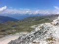
Goditi la vista a 3000 m di altitudine e fai un'escursione attraverso la natura incontaminata sopra la Val d'Anniviers
Panoramica:
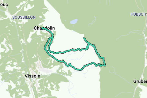
Questa escursione ti porta lontano dalla civiltà, dalla natura pura al suo meglio. Dopo aver scalato due cime, Rothorn e Bella Tolla, scendiamo verso Pas de Boeuf nel vasto deserto roccioso. Torniamo dal Passo Meidpass alla civiltà al punto di partenza: Chandolin.
Suggerimenti:
Per questa escursione devi essere un po 'più esperto.
Ci sono due parti difficili in questa escursione. Prima scende su una corda alla Bella Tolla. Il secondo è il campo di detriti fino a Pas de Boeuf, dove devi seguire i resti di vernice, mucchi di pietre, mappa topografica e istruzioni GPS.
A causa dell'altitudine di questa escursione, il tempo deve essere buono, con poca neve sotto i 3000 m. Se il punto di congelamento è di circa 4000 m e bel tempo caldo, questo è l'ideale.
Montagna:
Rothorn (Phare de Griolet) 2998m
Bella Tolla 3024m
Punto di partenza:
Chandolin, centro del paese in Val d'Anniviers
Indicazioni:
- Cabane de la Bella Tolla
- Bella Tolla - Rothorn
- Passo di Boeuf
- nessun percorso - colore
- Passo Meidpass
- Chalet Blanc
- Tignousa
- Chandolin
Navigate route in...
![]() RouteYou app Open
RouteYou app Open
Don't want to see this ad anymore?
→ Upgrade now
![]()
Please wait, the navigation is being prepared.
You can now navigate. Have fun on the road!
Processing your request has failed. Please try again.
Don't want to see this ad anymore?
→ Upgrade now
![]()
Please wait, your download is being prepared.
Your download is ready. Have fun on the road!
Processing your request has failed. Please try again.
Don't want to see this ad anymore?
→ Upgrade now
![]()
Please wait, your print is being prepared.
Your print is ready to download. Have fun on the road!
Processing your request has failed. Please try again.
Don't want to see this ad anymore?
→ Upgrade now
![]()
Please wait, your download is being prepared.
Your download is ready. Have fun on the road!
Processing your request has failed. Please try again.
<iframe src="https://plugin.routeyou.com/routeviewer/free/?language=en&params.route.id=2260654&params.language=it" width="100%" height="600" frameborder="0" allowfullscreen></iframe>
<a href="https://www.routeyou.com/it-ch/route/view/2260654/itinerario-per-trekking/bella-tolla-3024m-rothorn-2998m-fino-a-meidpass-e-ritorno?utm_source=embed&utm_medium=article&utm_campaign=routeshare" title="Bella Tolla (3024m), Rothorn (2998m) fino a Meidpass e ritorno - RouteYou" target="_blank"><img src="https://image.routeyou.com/embed/route/960x670/2260654-it@2x.png" width="960" height="670" alt="Bella Tolla (3024m), Rothorn (2998m) fino a Meidpass e ritorno"></a>
Additional feedback:
Try this feature for free with a RouteYou Plus trial subscription.
If you already have such an account, then log in now.
Try this feature for free with a RouteYou Premium trial subscription.
© 2006-2024 RouteYou - www.routeyou.com