5223 keer bekeken | Publiek | Frans • Nederlands
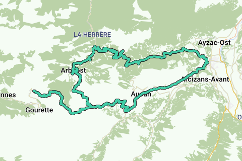
Immediately after the start in the center of Argelès-Gazost, it climbs. You take the first 500 meters of the Col du Soulor, but soon it turns right towards Gez. Here you start at the Col des Spandelles (1,378 m). Good for 15.5 kilometers of climbing at an average slope of 6.0%. But make no mistake, this whimsical, unevenly wooded
The ascent reaches heights of up to 13%! At the top, you have a
Impressive view of the valley that awaits you. The descent is a delight for anyone who loves short turns. In wet weather, it is important to be careful. Once you arrive at the bottom of the village of Ferrières you barely have time to catch your breath, because you immediately start the ascent
of the Col du Soulor. The Col du Soulor is one of the famous passes in the Pyrenees frequented by the Tour de France. The north side of the Soulor is 12 kilometers long and is a very steady climb with an average of 8%. Totally different from the Spandelles just now. The last 5 kilometers you will be presented with a fantastic panorama. If you look to the right, you can even see the road that leads to the top of the Aubisque. During the ascent and at the summit of Soulor (1,474 m), you will notice different types of stray cattle. Don't worry, they are totally innocent. Those who have reached the summit of Soulor without too many problems should take a break and go around to the summit of Aubisque (1,709m). From the
At the top of the Soulor, the Aubisque is relatively easy to access. It is barely 10 kilometers, of which only the last 4 kilometers can be considered "climbing". The Col d'Aubisque is one of the classic passes of the Tour de France, and has been conquered twelve times by a Belgian, including Eddy Merckx and Lucien Van Impe.
Navigeer de route met...
![]() RouteYou app Open
RouteYou app Open
Deze advertentie niet meer zien?
→ Upgrade nu
![]()
Even geduld, de navigatie wordt voorbereid.
Je kan nu navigeren. Veel plezier onderweg!
Het verwerken van de aanvraag is mislukt. Gelieve het opnieuw te proberen.
Deze advertentie niet meer zien?
→ Upgrade nu
![]()
Even geduld, je download wordt voorbereid.
Je download is klaar. Veel plezier onderweg!
Het verwerken van de aanvraag is mislukt. Gelieve het opnieuw te proberen.
Deze advertentie niet meer zien?
→ Upgrade nu
![]()
Even geduld, je afdruk wordt voorbereid.
Je afdruk is klaar om te downloaden. Veel plezier onderweg!
Het verwerken van de aanvraag is mislukt. Gelieve het opnieuw te proberen.
<iframe src="https://plugin.routeyou.com/routeviewer/free/?language=nl&params.route.id=2313573&params.language=en" width="100%" height="600" frameborder="0" allowfullscreen></iframe>
<a href="https://www.routeyou.com/en-fr/route/view/2313573/road-bike-route/col-de-spandelles-col-de-soulor?utm_source=embed&utm_medium=article&utm_campaign=routeshare" title="Col de Spandelles - Col de Soulor - RouteYou" target="_blank"><img src="https://image.routeyou.com/embed/route/960x670/2313573-en@2x.png" width="960" height="670" alt="Col de Spandelles - Col de Soulor"></a>
Bijkomende feedback:
Probeer deze functionaliteit gratis met een RouteYou Plus-proefabonnement.
Als je al een dergelijke account hebt, meld je dan nu aan.
Probeer deze functionaliteit gratis met een RouteYou Premium-proefabonnement.
Als je al een dergelijke account hebt, meld je dan nu aan.
© 2006-2024 RouteYou - www.routeyou.com