THE LONDON CITY VIEWS RING WALK
[Nederlandse tekst onderaan]
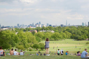
London has arisen in the Thames Delta, in the middle of a marshland barely 5 to 10 meters above sea level. One mustn’t go far to observe that geography beautifully and clearly in the cityscape: from Parliament Hill at Hampstead Heath or the Royal Observatory in Greenwich Park, one overlooks the Thames Valley, the whole city is there at your feet. But the - in some places quite steep – valley walls, and the surrounding hills, offer more wide panoramas of the city and its suburbs in Surrey, Essex and Hertfordshire. We connect all this sometimes surprising, always impressive views on the city through a 160 km hiking trail. The London City Views Ring Walk leads through large greens and commons, over hill tops and forgotten viaducts, by ancient villages in the city. Behind every corner is a new discovery, and all points on the trail are easily reached by subway, overground or bus. An ideal way to get to know this fascinating city!
An overview of the whole project route can be found here: https://www.gpsies.com/map.do?fileId=uqhqrafolytijvuu.
[Dutch text]
Londen is ontstaan in de Thamesdelta, te midden van een moerasgebied dat nauwelijks 5 tot 10 meter boven de zeespiegel uitsteekt. Ver moet je niet gaan om die geografie mooi en duidelijk in het stadslandschap te observeren: vanop Parliament Hill op Hampstead Heath of het Royal Observatory in Greenwich Park kijk je uit over de Thamesvallei, de hele stad ligt er aan je voeten. Maar de – op sommige plaatsen behoorlijk steile – valleiwanden, en de omringende heuvels, bieden wel meer weidse panorama’s over de kernstad en haar voorsteden in Surrey, Essex en Hertfordshire. Al die soms verrassende, altijd indrukwekkende uitzichten op de City verbinden we via een 160 km lange wandelroute. De London City Views Ring Walk trekt door grootse parken, langs vergeten groenlinten en viaducten, over heuveltoppen en door oude stadsdorpjes. Achter elke hoek schuilt een nieuwe ontdekking, en alle punten op de wandelroute zijn makkelijk te bereiken met metro, overground of bus. Een ideale manier om deze boeiende stad van zeer dichtbij te leren kennen!
Een overzicht van de hele ontwerproute vind je hier: https://www.gpsies.com/map.do?fileId=uqhqrafolytijvuu.
Mostrar rutasMostrar lugares de interés
<iframe src="https://plugin.routeyou.com/mapsearch/free/?language=es&params.group.id=10733" width="100%" height="600" frameborder="0" allowfullscreen></iframe>
Pruebe esta funcionalidad gratis con una suscripción de prueba RouteYou Plus.
© 2006-2024 RouteYou - www.routeyou.com