6795 visitas | Pública | Francés
Overview:
Three days along the borders of the river Semois in the Ardens along the nicest places. One of the most beautiful GR routes in Belgium with a varying trail and climbs witch puts you to your limits. This guide takes you on a heavy journey along the Semois with many panoramic views, small trails, rock formations, typical villages, steep climbs and much much more.
Day 1: Mortehan - Bouillon: 31km
Height difference: +687m -779m
Starting point: Camping Les Ochay - Mortehan
Ending point: Youth hostel - Bouillon
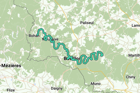
Day one is the easiest of the three day hike, we start in the small town of Mortehan at the border of the Semois near Pont de Linglé at the camping site of "Les Ochay". From here we pick up the GR16 trail signs (red-white stripes) in the direction of Bertrix. We never leave the GR trail until we reach Bouillon so its just enjoying the views and trails.
Day 2: Bouillon - Chairiére: 29km
Height difference: +1226m -1370m
Starting point: Youth hostel - Bouillon
Ending point: Camping "Le Trou du Cheval" - Chairiére
Day two is the heaviest day of all so be prepared! Best is to start early in Bouillon so you'll have enough time to reach the campingsite in Chairiére. We pick up the GR trail on the bridge Pont de France in the center of Bouillon where the Semois flows. From here we do not leave the GR16 trail until we reach Chairiére to reach the camping site. The camping site is located close to the GR trail so it's not much of a detour.
Day 3: Chairiére - Membre: 10,3km
Height difference: +731m -923m
Starting point: Camping "Le Trou du Cheval" - Chairiére
Ending point: Membre
Day three is the day to return, we do not give up the GR16 trail yet. You'll hike further along the GR16 trail to Membre-Sur-Semois, there you can take the bus back to Menuchenet to head back to the starting point. But if your condition is still OK after day two, you might hike to the last village before the French border. After the short bustrip to Menuchenet, we hike from the busstop back to the camping "Les Ochay" where we started the first day (this part is not included and is optional).
Tips:
The three day hike is very long (30km a day!). First day is way good, second day puts you to the limit. Plan this hike good and look out for the places to stay, places to eat and get water, bus times, etcetera.
Also we advice you to buy the Topo-Guide de GR16: Sentier de la Semois with plenty of more information on the GR.
Navegar ruta en...
![]() Aplicación RouteYou Abre
Aplicación RouteYou Abre
¿No quieres ver más este anuncio?
→ Mejorar ahora
![]()
Espere, se está preparando la navegación.
Ahora puede navegar. ¡Diviértete en el camino!
El procesamiento de la solicitud ha fracasado. Por favor, inténtelo de nuevo.
¿No quieres ver más este anuncio?
→ Mejorar ahora
![]()
Espere, se está preparando su descarga.
Su descarga esta lista. ¡Diviértete en el camino!
El procesamiento de la solicitud ha fracasado. Por favor, inténtelo de nuevo.
¿No quieres ver más este anuncio?
→ Mejorar ahora
![]()
Espere, se está preparando su impresión.
Su impresión está lista para descargarse. ¡Diviértete en el camino!
El procesamiento de la solicitud ha fracasado. Por favor, inténtelo de nuevo.
¿No quieres ver más este anuncio?
→ Mejorar ahora
![]()
Espere, se está preparando su descarga.
Su descarga esta lista. ¡Diviértete en el camino!
El procesamiento de la solicitud ha fracasado. Por favor, inténtelo de nuevo.
<iframe src="https://plugin.routeyou.com/routeviewer/free/?language=es&params.route.id=2260600&params.language=en" width="100%" height="600" frameborder="0" allowfullscreen></iframe>
<a href="https://www.routeyou.com/en-be/route/view/2260600/hiking-route/gr16-sentier-de-la-semois-mortehan-membre?utm_source=embed&utm_medium=article&utm_campaign=routeshare" title="GR16 Sentier de la Semois: Mortehan - Membre - RouteYou" target="_blank"><img src="https://image.routeyou.com/embed/route/960x670/2260600-en@2x.png" width="960" height="670" alt="GR16 Sentier de la Semois: Mortehan - Membre"></a>
Comentarios adicionales:
Pruebe esta funcionalidad gratis con una suscripción de prueba RouteYou Plus.
Si ya dispone de dicha cuenta, conectarse ahora.
Pruebe esta funcionalidad gratis con una suscripción de prueba RouteYou Premium.
© 2006-2024 RouteYou - www.routeyou.com