Source: TOV
Droits d'auteur: All rights reserved
1027 vues | Publique | Néerlandais
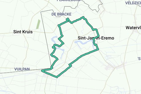
Meet at the stately, neo-Gothic town hall of Sint-Laureins for a walk along the many creeks of Sint-Laureins, Sint-Margriete and SintJan-in-Eremo (V). The creeks bear witness to the floods from the twelfth century onwards, in particular the Elisabeth Flood of 1377, in which some villages even disappeared completely. Leave, with your back to the town hall, to the right in the Dorpsstraat. You immediately walk past the monumental late Gothic St. Lawrence Church. It is one of the most beautiful churches in the Meetjesland, protected since 1936. Ignore all side streets and walk at the end of the Dorpsstraat to the left into the Goochelaarstraat. After 200 meters, turn right over a wide ditch and then immediately turn left on a gravel path next to the same ditch. The gravel path brings you back to the concrete track. Ignore the exits on the right and left and walk straight on the single-lane concrete track. Even now, for almost a kilometer, ignore all side streets and step left into the Langeweg at the T-junction, and then after only 150 meters to the right, still on a single-lane concrete track. • After more than a kilometer you will arrive at the Beoostereedepolderdijk. Turn left and you will be at the Solar Bridge and the Leopold Canal. The Leopold Canal was dug by hand between 1843 and 1954 and is 46 kilometers long. It put an end to the flooding and the associated polder and swamp fever and still has an important drainage function for the surrounding polders. Do not cross the canal, but walk to the right between two straight rows of trees along the water. The water feature on the right is the Bentille Creek. At the end of the drive, turn left over the Sint-Jansbrug and along the steenweg. The water basin on the right is the Oostpolderkreek. Soon you will arrive at the sports center De Boerekreek 1. Walk to the left on the cobblestone lane between the two car parks and, once past the buildings, climb up the dike. • Under the dike is the beautiful Boerekreek. It is the largest creek in the Meetjesland. Part of it is a nature reserve managed by Natuurpunt and another part is operated by the province as a sports centre. Walk to the right on the dike, and after 500 meters you step down the dike via a staircase to the right. The asphalt track takes you to the beautiful church of Sint-Jan-in-Eremo. The Sint-Janskerk 2 and the surrounding land and ditch have been protected as a monument and landscape since 1975. Walk straight ahead in the Hogestraat and turn left at the T-junction. After 500 meters on the wider asphalt track, turn left again. Turn right at the roundabout, ignore the exit to Waterland-Oudeman after more than a kilometer and walk to the left in the Molenkreekstraat. After a few hundred meters you have the Molenkreek and a picnic area 3 . • At the fork, walk to the right towards Sint-Margriete and in the bend, next to house number 22, to the right on a gravel road. The gravel road takes you past the cemetery and to the church of Sint-Margriete 4. Walk past the church and on the main road to the left and then after 150 meters to the right in the Hontseindestraat. After 800 meters, turn left into Groenstraat. Ignore a left turn and turn right at the next intersection (junction 87 of Meetjesland hiking network). Walk left at the T-junction and after 500 meters at hiking junction 97 to the right. After another 750 meters you come to a picnic area 5 between the idyllic Hollandersgat creek and the Blokkreek. Turn left at the T-junction and turn left again at the next intersection, always towards SintLaureins. You will now pass the Vrouwkenshoekkreek 6. Here, too, Natuurpunt manages a nature reserve. It is the breeding ground of rare birds such as marsh harrier, reed warbler and bluethroat. Walk to the right at the fork. A little further in the bend is boundary post number 341. Soon you will walk again along the Leopold Canal. Cross the canal at the Moershoofdebrug and walk to the left towards the village with town hall and church
Parcourir l'itinéraire dans...
![]() Application RouteYou Ouvrez
Application RouteYou Ouvrez
Plus voir cette annonce?
→ Améliorez maintenant
![]()
Veuillez patienter, la navigation est en cours de préparation.
Vous pouvez maintenant naviguer. Amusez-vous en route!
Le traitement de votre requête a échoué. S'il vous plaît réessayez.
Plus voir cette annonce?
→ Améliorez maintenant
![]()
Veuillez patienter, votre téléchargement est en cours de préparation.
Votre téléchargement est prêt. Amusez-vous en route!
Le traitement de votre requête a échoué. S'il vous plaît réessayez.
Plus voir cette annonce?
→ Améliorez maintenant
![]()
Veuillez patienter, votre impression est en cours de préparation.
Votre impression est prête à être téléchargée. Amusez-vous en route!
Le traitement de votre requête a échoué. S'il vous plaît réessayez.
Plus voir cette annonce?
→ Améliorez maintenant
![]()
Veuillez patienter, votre téléchargement est en cours de préparation.
Votre téléchargement est prêt. Amusez-vous en route!
Le traitement de votre requête a échoué. S'il vous plaît réessayez.
<iframe src="https://plugin.routeyou.com/routeviewer/free/?language=fr&params.route.id=5343472&params.language=en" width="100%" height="600" frameborder="0" allowfullscreen></iframe>
<a href="https://www.routeyou.com/en-be/route/view/5343472/recreational-walking-route/along-the-water-in-sint-laureins?utm_source=embed&utm_medium=article&utm_campaign=routeshare" title="Along the water in Sint-Laureins - RouteYou" target="_blank"><img src="https://image.routeyou.com/embed/route/960x670/5343472-en@2x.png" width="960" height="670" alt="Along the water in Sint-Laureins"></a>
Commentaires supplémentaires:
Essayez cette fonctionnalité gratuitement avec un abonnement d'essai RouteYou Plus.
Si vous avez déjà un tel compte, connectez-vous maintenant.
Essayez cette fonctionnalité gratuitement avec un abonnement d'essai RouteYou Premium.
© 2006-2024 RouteYou - www.routeyou.com