Risorsa: Wizpr.guide
Diritti d'autore: All rights reserved
5663 visite | Pubblica | Olandese
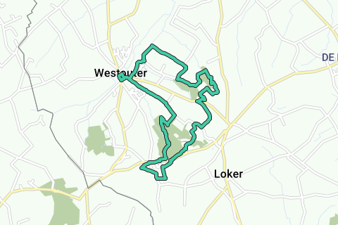
Meet in the Poperingestraat, on the square next to the Sint-Eligiuskerk of Westouter, unofficially called the Neerplaats (V), at the walking information boards. You start at junction 1 towards junction 19 and walk around the cemetery and the church. Then turn left, past the town hall and right into Hellegatstraat. Walk out of the village past the rectory, among meadows with pollard willows. At junction 19 straight ahead, direction 10. At the intersection with the Kwadestraat you walk from junction 10, direction 11. Then turn right, into the Rodenberg domain forest, direction 24. Until that junction it goes gently uphill. Then gently downhill, towards 23, the road next to the wire fence. Junction 23 is located at the end of the play forest. Turn left here, direction 65 and 38. There will also be a GR path. At the fork you have the choice: keep following the GR signs or the path along the wire fence. Further on, both paths come together again and continue between two wire fences. You ignore a path on the left and continue to follow the wire closure. Cross a small bridge and then continue walking on a boardwalk. After a second bridge you go back into the forest, this time up sharply. Continue to follow the path until you reach junction 38. Turn right here, direction 39. Via a sasje you reach the N372. Cross it and then turn right on the narrow pedestrian path. Continue walking between Berg en Dal and the Bergbloem until junction 39 with a white Saint Godelieve chapel. Here you turn left, via the Schommelinkstraat, direction 40. You step under a chairlift and then along the mini golf of Berg en Dal. At junction 40, take the field road on the left, direction 37. You climb via a staircase, past holiday home De Oude Bergtronk from 1831. On the left the vineyard of domain de Baneberg. At the T-junction, ignore a sasje and turn left. At Lijstermolen 1 and restaurant Molenhof turn right and diagonally across the car park until junction 37. On the right a panorama of the flat land around the church of Loker. Then step to junction 36, nearby. At café De Nachtegaal you cross the N372 and you are at point 36. You walk again through domain forest Rodenberg, towards 34. On the T you are already out of the forest and you are at junction 34. Turn left, direction 32. You turn right with the road and step past the former holiday center De Kosmos, owned by the Flemish government since July 2009. Continue to junction 32 and then to 31, 100 m away. Here turn left on a narrow field road towards 27. You reach that after a few turns at a T-junction. Follow the asphalt road to the right, direction 29, until you can turn left into a field road. Follow this Kromwegelken between meadows and fields to the end. Cross the N315 and climb along the edge of the forest to junction 29. Turn left and continue 100 m at junction 28 to the right across the meadow. Now you walk, with the Scherpenberg 2 in front of you, between the fields over the Oostcapellewegelken and the Kromwegelken to junction 13. Turn left, on a narrow path between the fields, direction 12. The view is magnificent. Then you walk through nature reserve Brandersbos (3) on boardwalks that are in a distant state of decomposition. At a wire fence to the left into the forest, further over a bridge and via the cascading platform path you reach the wire fence again. Follow it to the left until you reach an asphalt road (or follow the network, again to the left to point 12, through the green). Left. After a bend you will arrive at junction 12. Right. You still sit on the valley road. Before you beckons the historical ferme de Wé of Opprebais. At the (h)honestly scented outbuildings you turn left and just before the entrance gate of the main building you turn left again. Attention, just after the first white house you have to turn right into a narrow church road (promenade du moulin). Cross one field, twice through a merry-go-round and you are in Opprebais village. Always straight ahead, crossing the rue du Saussois and again into a church road, past a meadow now. You arrive at a T and walk to the left, towards the center (rue d'en Haut). On the 'Place' go straight ahead. On the left the school, on the right the church 4 and the rugged medieval castle farm, with four crumbling corner towers from the 14th century. Continue straight ahead, cross the intersection and follow rue de la Justice until no. 9. There you turn right into the hollow road. It passes just below the white moulin Gustot, a stone ground sailer from 1854. Beautifully restored, but it can no longer be milled. You follow the concrete connecting road to the left until you can pick up on a left on a field road, to Sart-Risbart. At the first farm on the right and at the T on the left. In the village, follow rue Alphonse Robert until no. 38. Directly opposite, a church road leads to the fifth tower: keep the first fork to the left and continue until just before church 5 follow the church road to rue Robert. Turn right until you can turn left into rue Ste. Wivine (arrow to Perwez). In a wide bend, take the fork on the left, direction ferme de la Grande Risbart. The cobblestone road turns in a big bend to the back of that beautiful white homestead (with holiday home). Walk right up to the first company building and choose on the left. If you spot a pond a little further to the right, you're in the right place. A long straight field road, type up-and-down, is heading towards the wind turbines on the horizon. And to Malè- ves, hidden on the way in the valley of the Orbais. Ignore all side roads. Descend via rue Sainte Wivine to Place Communale. walks along the Sulferberg nature reserve to junction 18. Turn right here, direction 16. Where the asphalt road bends right, you go straight on a gravel road. At junction 16, turn left towards 17. Via the Roode beek-wegelken you enter the Blauwepoortstraat. Here you leave the hiking network. Turn right, past the football field to the Hellegatstraat and then turn right again until the starting point.
Naviga nel percorso in...
![]() App RouteYou Aprire
App RouteYou Aprire
Vuoi smettere di vedere questo annuncio?
→ Upgrade ora
![]()
Attendi, la navigazione è in preparazione.
Ora puoi navigare. Buon divertimento in viaggio!
Elaborazione della richiesta non è riuscita. Si prega di riprovare.
Vuoi smettere di vedere questo annuncio?
→ Upgrade ora
![]()
Attendi, il tuo download è in preparazione.
Il tuo download è pronto. Buon divertimento in viaggio!
Elaborazione della richiesta non è riuscita. Si prega di riprovare.
Vuoi smettere di vedere questo annuncio?
→ Upgrade ora
![]()
Attendi, la tua stampa è in preparazione.
La tua stampa è pronta per il download. Buon divertimento in viaggio!
Elaborazione della richiesta non è riuscita. Si prega di riprovare.
Vuoi smettere di vedere questo annuncio?
→ Upgrade ora
![]()
Attendi, il tuo download è in preparazione.
Il tuo download è pronto. Buon divertimento in viaggio!
Elaborazione della richiesta non è riuscita. Si prega di riprovare.
<iframe src="https://plugin.routeyou.com/routeviewer/free/?language=it&params.route.id=5346779&params.language=en" width="100%" height="600" frameborder="0" allowfullscreen></iframe>
<a href="https://www.routeyou.com/en-be/route/view/5346779/recreational-walking-route/through-the-hills-at-westouter?utm_source=embed&utm_medium=article&utm_campaign=routeshare" title="Through the hills at Westouter - RouteYou" target="_blank"><img src="https://image.routeyou.com/embed/route/960x670/5346779-en@2x.png" width="960" height="670" alt="Through the hills at Westouter"></a>
Altri commenti:
Prova questa funzionalità gratuitamente con un abbonamento di prova RouteYou Plus.
Se hai già un tale account, accedi ora.
Prova questa funzionalità gratuitamente con un abbonamento di prova RouteYou Premium.
© 2006-2024 RouteYou - www.routeyou.com