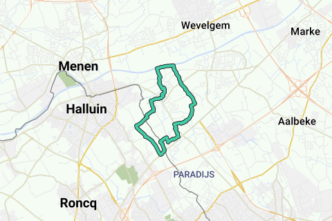
3461 visitas | Pública | Francés • Neerlandés
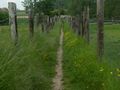
We explore the village by slow roads. We partly follow the path of the "blues" (smugglers) and sometimes cross the paths of the "caziezen" (customs officers). Our eyes are stimulated by a typical patchwork of rows of houses, fields and meadows, industrial buildings, villas accompanied by a varied range of koterijen,... It is a chaotic landscape that sizzles between beauty and ugliness. With some beautiful views, narrow paths, springboards and agricultural roads ensure a pleasant walk about 9 km long. The walk is not suitable for wheelchairs and strollers. In wet weather, good walking shoes are recommended.
We go to the Sint-Niklaas church. The church was built in the 12th century. The Romanesque tower and transept are the oldest remaining parts. The ship was rebuilt in the 17th century after a fire. Near the church there are spacious parking spaces. We descend the Kasteeldreef towards the porch of the church. At the intersection with the Moeskroenstraat, we notice a country road on the other side, the Murissonwegel. Also note the Smuggler's Path designation. We will continue to follow the directions of the smugglers' trail for a long time. The original paved strip of the Murissonwegel quickly turns into a dirt road.
The Murissonwegel flows into the Murissonstraat. We turn left into the street and ignore a street to the right and also the Sint-Niklaasdreef on the left. On the right in the distance, we notice 2 church towers of Halluin (Halewijn). The tower on the left is that of the church of Saint-Alphonse, the other of the church of Saint-Hilaire.
We turn right (Smuggler's Path) and then turn right again after 100 meters in a farm. The street revolves around a farm. We leave the country road in front of us and turn sharply to the right. When we reach the first row of houses, we have crossed the border with the France. We are in the Way of Reckem. The "Schreve" has a very erratic course here to which is attached a fascinating story. The borders between France and the Netherlands were fixed by the Treaty of Kortrijk in 1820.
The road leads to the Chemin des Meurins. We turn left and ignore all side streets until we reach a fork of 3 roads. We walk left in the cul-de-sac, Chemin Vert. We also ignore all the side streets here and unfortunately also the Pilori Way and the Pipoli Road. Pillory refers to a place where there was a pillory. It was the pillory of the lordship of Meurins. The street exits a wide country road. On this country road we have a beautiful view of the Leie valley. We even have a view of Wevelgem (De Posthoorn with the typical green dome of the Sint-Theresia church) on the right. (Photos 1 and 2)
The country road ends at the end of Rue de Dronckaert. We turn left and continue to follow the trail until we return to Belgium. Just after the sign "Rekkem" on the right, the links between 2 houses find a paved road. We ignore all the side branches on this road and we find ourselves on a beautiful country road. This winding country road takes us to the building of the Ons Erfdeel Foundation. In short, the foundation is committed to making the culture of Flanders and the Netherlands known abroad.
We stop at the border at the poem on the border by Jozef Deleu, one of the founders of the Ons Erfdeel.
"Why shouldn't the most ideal country have borders?
Limits are not always limiting.
They offer opportunities for retreat in times of tyranny.
They offer opportunities for a new beginning and very often for a new life. »
We descend from the OnsErfdeelwegel and turn right into the Murissonstraat. We ignore the Nobelstraat on the left and turn left a few meters further left into the Kattewegel.
The Kattewegel divides further. We keep the right to see. At the next fork, we turn left. The wegel runs along the Tibeertstraat. We follow the wegel and cross the street to continue following the Kattewegel. We ignore a side street on the left and finally arrive at Kattestraat. We turn right into the Kattestraat to arrive at the busy Moeskroenstraat (N366).
We cross the Moeskroenstraat and turn a hundred meters further right into a road (designation 804 ADCD/000 and Smuggler's Path). We then find ourselves in the Berghenswegel. After all, the stone falling on the Kloosterhoek. We turn left and shortly after, turn right into a street. The street will lead to the Kloosterhoekwegel (Voetweg Nr. 20) (Photo 3)
We cross the Palingbeek and climb to the Kraaiveld. The trail is lined with plants that thrive under extensive agriculture. Arriving at the Kraaiveld, we ignore a path (off-road bike path) on the right. The path leads to a Kraaiveld street. We keep left and follow the signs Smuggler's Path and Short Car Path. (Photo 4)
We reach the Leopold Sabbestraat which we turn left and then turn right into the Waterstraat. We then cross the Rekkemstraat. Where the road turns left, we stay right (Menenstraat). Shortly after, we ignore the exit on the right and we enter straight into the cul-de-sac (bike junction 8). We ignore another exit on the left and arrive at the Lys (Taverne 't Leienhof).
At the Lys, much too straight, we walk left on the towpath (direction Menen) (Photo 5). The towpath is zoomed in with an ash tree. Notice the rich roadside flora and spontaneous storage of trees. On the other side of the Leie we see the green tower of Sint Theresiakerk on the Posthoorn (Wevelgem) standing. Further on, the Palingbeek flows into the Leie.
At the cycle exit 78 (with indication Rekkem 1.2), we leave the towpath on the left. Notice the altered sign "'t Heelwegelke" between the plant's growth (Photo 6). The road leads us in front of some sheds to throw us into PontNeuf Street. We keep right and shortly after, turn left into the Heelewegel (follow bike exit 59). We cross the Vierwegenstraat (turn right and shortly after left) to continue following the Heelewegel. After crossing the Meurissonbeek, we arrive at the TenDalewegel. We walk left on the road and follow the stream. The Meurissonbeek flows into the Palingbeek. We leave the bridge over the Palingbeek and take off the slight slope. We leave the road. The wegel turns right into the residential area at the end. We walk out of the street and notice the tower of the Sint-Niklaas church at the end. We turn left and return to the starting point of the walk.
This promenade was designed by Bernard Decock. Photos Bernard Decock.
This walk has already appeared in Ivy, volume 28 number 4.
Ivy is the magazine member of Natuur.koepel asbl. More info: http://www.natuurkoepel.be
Navegar ruta en...
![]() Aplicación RouteYou Abre
Aplicación RouteYou Abre
¿No quieres ver más este anuncio?
→ Mejorar ahora
![]()
Espere, se está preparando la navegación.
Ahora puede navegar. ¡Diviértete en el camino!
El procesamiento de la solicitud ha fracasado. Por favor, inténtelo de nuevo.
¿No quieres ver más este anuncio?
→ Mejorar ahora
![]()
Espere, se está preparando su descarga.
Su descarga esta lista. ¡Diviértete en el camino!
El procesamiento de la solicitud ha fracasado. Por favor, inténtelo de nuevo.
¿No quieres ver más este anuncio?
→ Mejorar ahora
![]()
Espere, se está preparando su impresión.
Su impresión está lista para descargarse. ¡Diviértete en el camino!
El procesamiento de la solicitud ha fracasado. Por favor, inténtelo de nuevo.
¿No quieres ver más este anuncio?
→ Mejorar ahora
![]()
Espere, se está preparando su descarga.
Su descarga esta lista. ¡Diviértete en el camino!
El procesamiento de la solicitud ha fracasado. Por favor, inténtelo de nuevo.
<iframe src="https://plugin.routeyou.com/routeviewer/free/?language=es&params.route.id=5684987&params.language=en" width="100%" height="600" frameborder="0" allowfullscreen></iframe>
<a href="https://www.routeyou.com/en-be/route/view/5684987/recreational-walking-route/a-disparate-walk-in-rekkem?utm_source=embed&utm_medium=article&utm_campaign=routeshare" title="A disparate walk in Rekkem - RouteYou" target="_blank"><img src="https://image.routeyou.com/embed/route/960x670/5684987-en@2x.png" width="960" height="670" alt="A disparate walk in Rekkem"></a>
Comentarios adicionales:
Pruebe esta funcionalidad gratis con una suscripción de prueba RouteYou Plus.
Si ya dispone de dicha cuenta, conectarse ahora.
Pruebe esta funcionalidad gratis con una suscripción de prueba RouteYou Premium.
© 2006-2024 RouteYou - www.routeyou.com