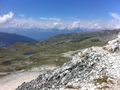
Enjoy the view on 3000m height and walk through pure untouched nature above Val d'Anniviers
Overview:
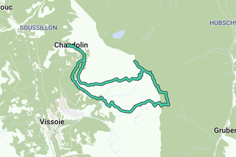
This hike takes you far away from civilization, pure nature at it's best. After climbing two summits, Rothorn and Bella Tolla, we climb down towards pas de Boeuf into the wide rocky desert. We return from the Meidpass back into civilization towards the starting point: Chandolin.
Tips:
For this hike you'll have to be a bit more experienced.
There are two difficult parts in this hike. First is climbing down along a rope at the Bella Tolla. Second is the debris field after Pas de Boeuf where you must follow the remnants of paint, piles of rocks, topo map and GPS guidance.
Due to the height of this hike the weather must be good with not much snow below 3000m. When freezing level is at 4000m and nice warm weather, thats ideal.
Mountain summits:
Rothorn (Phare de Griolet) 2998m
Bella Tolla 3024m
Starting point:
Chandolin, centre of the village in the Val d'Anniviers
Directions:
- Cabane de la Bella Tolla
- Bella Tolla - Rothorn
- Pas de Boeuf
- no route - paint
- Meidpass
- Chalet Blanc
- Tignousa
- Chandolin
Naviga nel percorso in...
![]() App RouteYou Aprire
App RouteYou Aprire
Vuoi smettere di vedere questo annuncio?
→ Upgrade ora
![]()
Attendi, la navigazione è in preparazione.
Ora puoi navigare. Buon divertimento in viaggio!
Elaborazione della richiesta non è riuscita. Si prega di riprovare.
Vuoi smettere di vedere questo annuncio?
→ Upgrade ora
![]()
Attendi, il tuo download è in preparazione.
Il tuo download è pronto. Buon divertimento in viaggio!
Elaborazione della richiesta non è riuscita. Si prega di riprovare.
Vuoi smettere di vedere questo annuncio?
→ Upgrade ora
![]()
Attendi, la tua stampa è in preparazione.
La tua stampa è pronta per il download. Buon divertimento in viaggio!
Elaborazione della richiesta non è riuscita. Si prega di riprovare.
Vuoi smettere di vedere questo annuncio?
→ Upgrade ora
![]()
Attendi, il tuo download è in preparazione.
Il tuo download è pronto. Buon divertimento in viaggio!
Elaborazione della richiesta non è riuscita. Si prega di riprovare.
<iframe src="https://plugin.routeyou.com/routeviewer/free/?language=it&params.route.id=2260654&params.language=en" width="100%" height="600" frameborder="0" allowfullscreen></iframe>
<a href="https://www.routeyou.com/en-ch/route/view/2260654/hiking-route/bella-tolla-3024m-rothorn-2998m-to-the-meidpass-and-back?utm_source=embed&utm_medium=article&utm_campaign=routeshare" title="Bella Tolla (3024m), Rothorn (2998m) to the Meidpass and back - RouteYou" target="_blank"><img src="https://image.routeyou.com/embed/route/960x670/2260654-en@2x.png" width="960" height="670" alt="Bella Tolla (3024m), Rothorn (2998m) to the Meidpass and back"></a>
Altri commenti:
Prova questa funzionalità gratuitamente con un abbonamento di prova RouteYou Plus.
Se hai già un tale account, accedi ora.
Prova questa funzionalità gratuitamente con un abbonamento di prova RouteYou Premium.
© 2006-2024 RouteYou - www.routeyou.com