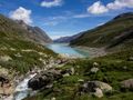
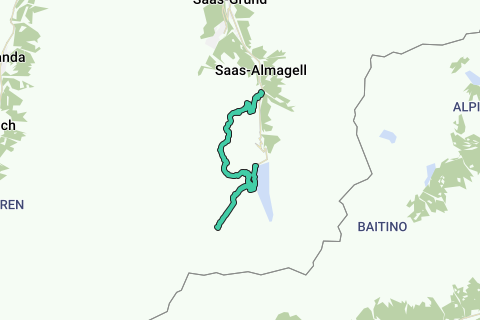
This route takes you along three glaciers of the Saas-Almagell valley in Switzerland. Starting from the Mattmark Stausee Dam you'll visit the first glacier "Schwarzberggletscher" which you can almost touch, the second glacier on the route is the Allalingletscher which you'll cross followed by the third and last glacier "Hohlaubgletscher".
!!!WARNING!!! T4 - Alpine Hike !!!WARNING!!!
This hike contains glacier crossing. You must be surefooted, have good mountain experience. Not to perform in bad weather or when snow covers the crevasses. Due to the melting of the glaciers new crevasses can open up or make the paths different. Inform you at the Britanniahütte or tourism bureau to know if the conditions of the glacier is good to cross.
The route starts at the Mattmark Stausee, parking there is easy but it isn't a free parking. There is also a bus station at the dam to make it easy accessible.
You follow the right side of the lake until a junction in the direction of Schwarzbergchopf en Schwarzberggletscher. At the next junction we take the path to the glacier. You'll follow this path until you can't see a path anymore. It is still possible to go further and go just on the glacier but that requires more experience. From this point you'll have a superb view over the Schwarzberggletscher. The return is along the same route to the junction we have passed in the start, you now go in the direction of the Schwarzbergchopf/Britanniahütte. From there it's a small and sometimes steep path to the summit of the Schwarsbergchopf. This neat little peak offers a great view over the Allalin glacier which you'll cross. On the summit you head in the direction of the glacier, once on the glacier, the path is marked with blue poles. As with every glacier trail, you can't go straight from pole to pole, always look out for weaker spots in the glacier, crevasses, rocks, snow and find a path between. Once you crossed the Allalin glacier the path is very rocky, marked white/blue/white. Look out for loose rocks! Next up is the Hohlaub glacier and it's the most dangerous one with more crevasses. The Britanniahütte is now good in sight and is the next destination. It's a great mountain cabin with great view over the glaciers that you've crossed. After a good drink and something to eat it's time to head back to Saas-Almagell, descent along the almost completely vanished Chessjen glacier in northern direction, once reached a normal white/red/white marked path you follow this in the direction of Zermeiggern. A bus stop is there to take you back to the starting point.
Navigeer de route met...
![]() RouteYou app Open
RouteYou app Open
Deze advertentie niet meer zien?
→ Upgrade nu
![]()
Even geduld, de navigatie wordt voorbereid.
Je kan nu navigeren. Veel plezier onderweg!
Het verwerken van de aanvraag is mislukt. Gelieve het opnieuw te proberen.
Deze advertentie niet meer zien?
→ Upgrade nu
![]()
Even geduld, je download wordt voorbereid.
Je download is klaar. Veel plezier onderweg!
Het verwerken van de aanvraag is mislukt. Gelieve het opnieuw te proberen.
Deze advertentie niet meer zien?
→ Upgrade nu
![]()
Even geduld, je afdruk wordt voorbereid.
Je afdruk is klaar om te downloaden. Veel plezier onderweg!
Het verwerken van de aanvraag is mislukt. Gelieve het opnieuw te proberen.
Deze advertentie niet meer zien?
→ Upgrade nu
![]()
Even geduld, je download wordt voorbereid.
Je download is klaar. Veel plezier onderweg!
Het verwerken van de aanvraag is mislukt. Gelieve het opnieuw te proberen.
<iframe src="https://plugin.routeyou.com/routeviewer/free/?language=nl&params.route.id=4135650&params.language=en" width="100%" height="600" frameborder="0" allowfullscreen></iframe>
<a href="https://www.routeyou.com/en-ch/route/view/4135650/hiking-route/mattmark-glacier-trail?utm_source=embed&utm_medium=article&utm_campaign=routeshare" title="Mattmark Glacier trail - RouteYou" target="_blank"><img src="https://image.routeyou.com/embed/route/960x670/4135650-en@2x.png" width="960" height="670" alt="Mattmark Glacier trail"></a>
Bijkomende feedback:
Probeer deze functionaliteit gratis met een RouteYou Plus-proefabonnement.
Als je al een dergelijke account hebt, meld je dan nu aan.
Probeer deze functionaliteit gratis met een RouteYou Premium-proefabonnement.
© 2006-2024 RouteYou - www.routeyou.com