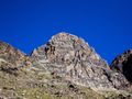
The Jegihorn is a 'small' peak above Saas-Grund (Saastal, Valais, Switzerland) with a height of 3206m. From the summit you'll get a tremendous view over the Weismiess (4017m) and it's glacier (Triftglacier) and the high 4000+m mountains above Saas-Fee.
!!!WARNING!!! T4 - Alpine Hike !!!WARNING!!!
This hike is a marked white/blue/white hike, meaning this is a difficult alpine trail only for experienced mountain hikers. The start of the trail is easy, once you climb the Jegihorn it changes from white/red/white T2 mountain path to alpine trail. From there the path is not always good visible, hands are needed to get over rocks, the last part to the summit is well marked but not easy to get through the pile of rocks. You must be surefooted and not afraid of heights and have mountain experience.
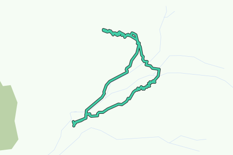
The hike starts at the Kreuzboden ski station, this lift is open in the summer and can be taken from Saas-Grund. From Kreuzboden we head in the direction of Jegihorn/Hohsaas along the skislope. A bit further a junction to the left will take you on the climb of the Jegihorn. Bit attention here because there are two ways, the left one is the normal route, the right one is the Via Ferrata/Klettersteig. We take the normal route to the left. The path is good at first but turns more difficult with the last part before the summit being a bit more hand/footwork. Return is along the same route, but instead of going straight back to Kreuzboden we'll take a visit to the Weismiesshütte Mountain Cabin before we head back to Kreuzboden.
The logged route on the map is not with the summit included, this is intentionally the case. it stops just below the summit where the path is relatively doable for the normal mountain hiker, from that point the path is getting tricky.
Parcourir l'itinéraire dans...
![]() Application RouteYou Ouvrez
Application RouteYou Ouvrez
Plus voir cette annonce?
→ Améliorez maintenant
![]()
Veuillez patienter, la navigation est en cours de préparation.
Vous pouvez maintenant naviguer. Amusez-vous en route!
Le traitement de votre requête a échoué. S'il vous plaît réessayez.
Plus voir cette annonce?
→ Améliorez maintenant
![]()
Veuillez patienter, votre téléchargement est en cours de préparation.
Votre téléchargement est prêt. Amusez-vous en route!
Le traitement de votre requête a échoué. S'il vous plaît réessayez.
Plus voir cette annonce?
→ Améliorez maintenant
![]()
Veuillez patienter, votre impression est en cours de préparation.
Votre impression est prête à être téléchargée. Amusez-vous en route!
Le traitement de votre requête a échoué. S'il vous plaît réessayez.
Plus voir cette annonce?
→ Améliorez maintenant
![]()
Veuillez patienter, votre téléchargement est en cours de préparation.
Votre téléchargement est prêt. Amusez-vous en route!
Le traitement de votre requête a échoué. S'il vous plaît réessayez.
<iframe src="https://plugin.routeyou.com/routeviewer/free/?language=fr&params.route.id=4143222&params.language=en" width="100%" height="600" frameborder="0" allowfullscreen></iframe>
<a href="https://www.routeyou.com/en-ch/route/view/4143222/hiking-route/jegihorn-3206m?utm_source=embed&utm_medium=article&utm_campaign=routeshare" title="Jegihorn (3206m) - RouteYou" target="_blank"><img src="https://image.routeyou.com/embed/route/960x670/4143222-en@2x.png" width="960" height="670" alt="Jegihorn (3206m)"></a>
Commentaires supplémentaires:
Essayez cette fonctionnalité gratuitement avec un abonnement d'essai RouteYou Plus.
Si vous avez déjà un tel compte, connectez-vous maintenant.
Essayez cette fonctionnalité gratuitement avec un abonnement d'essai RouteYou Premium.
© 2006-2024 RouteYou - www.routeyou.com