Datenquelle: Zwischbergenpass - Vancanneyt Sander
760 Aufrufe | Öffentlich | Deutsch • Französisch • Italienisch
This hike takes you to the end of the Almagellertal above Saas-Almagell to the mountain pass 'Zwischbergenpass' from where you'll get an amazing view over the Zwischbergental. Along the road we'll see two cabins from where you can relax a bit because it's a pretty long and breathtaking hike.
!WARNING! T3 - Challenging Mountain Hike !Warning!
This is a high mountain pass, parts of the hike can be covered with snowfields. Please inform yourself of the conditions at tourist information or hotel.
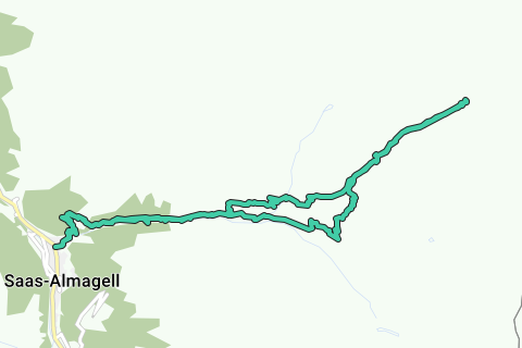
The route starts in Saas-Almagell, when entering the village you'll see a parking lot at the left where you can park (not a free parking!). From the parking lot you'll head in the direction of the waterfall, the signs indicate the Almagelleralp and Almagellerhütte which we'll follow. The start is steep so you'll be glad that you arrive at the Almagelleralp to rest a bit.
At the Almagelleralp cabin we take the path to the left and immediately right so that we take the high route to the Almagellerhütte instead of the lower path. It's also a more direct approach. The path keeps climbing further into the Almagellertal until you reach the Almagellerhütte at 2894m. Just before the cabin is a small snowfield that you have to cross.
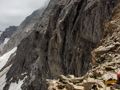
Take a nice rest at the Almagellerhütte, the toughest part has yet to come. The route is marked and starts with white-blue-white markings in the direction of "Weismiess", these markings will stop at some point and then you'll have to follow the old markings which aren't always that clearly visible anymore. You'll walk along the remnants of what was a glacier once with magnificent shaped rocks with the last piece containing snowfields and morene (loose small rocks) before making the final approach to the mountain pass. Once at the pass you'll be amazed by the view. it's an ideal place to have diner and rest a bit before turning back.
The return to the Almagellerhütte is the same, but just below the Almagellerhütte we'll take the left path at the junction so that we have an other path to the Almagelleralp. From the Almagelleralp it's the same path back to Saas-Almagell.
Route navigieren in...
![]() RouteYou-App Öffnen
RouteYou-App Öffnen
Diese Werbung nicht mehr anzeigen?
→ Jetzt upgraden
![]()
Bitte warten Sie, die Navigation wird vorbereitet.
Sie können jetzt navigieren. Viel Routen-Spaß!
Bearbeitung Ihrer Anfrage ist fehlgeschlagen. Bitte versuchen Sie es erneut.
Diese Werbung nicht mehr anzeigen?
→ Jetzt upgraden
![]()
Bitte warten Sie, Ihr Download wird vorbereitet.
Ihr Download ist fertig. Viel Routen-Spaß!
Bearbeitung Ihrer Anfrage ist fehlgeschlagen. Bitte versuchen Sie es erneut.
Diese Werbung nicht mehr anzeigen?
→ Jetzt upgraden
![]()
Bitte warten Sie, Ihr Ausdruck wird vorbereitet.
Ihr Ausdruck ist bereit für den Download. Viel Routen-Spaß!
Bearbeitung Ihrer Anfrage ist fehlgeschlagen. Bitte versuchen Sie es erneut.
Diese Werbung nicht mehr anzeigen?
→ Jetzt upgraden
![]()
Bitte warten Sie, Ihr Download wird vorbereitet.
Ihr Download ist fertig. Viel Routen-Spaß!
Bearbeitung Ihrer Anfrage ist fehlgeschlagen. Bitte versuchen Sie es erneut.
<iframe src="https://plugin.routeyou.com/routeviewer/free/?language=de&params.route.id=4149034&params.language=en" width="100%" height="600" frameborder="0" allowfullscreen></iframe>
<a href="https://www.routeyou.com/en-ch/route/view/4149034/hiking-route/zwischbergenpass-3268m?utm_source=embed&utm_medium=article&utm_campaign=routeshare" title="Zwischbergenpass (3268m) - RouteYou" target="_blank"><img src="https://image.routeyou.com/embed/route/960x670/4149034-en@2x.png" width="960" height="670" alt="Zwischbergenpass (3268m)"></a>
Zusätzliches Feedback:
Probieren Sie diese Funktionalität kostenlos mit einem RouteYou Plus-Probeabonnement.
Wenn Sie bereits ein solches Konto haben, melden Sie sich jetzt an.
Probieren Sie diese Funktionalität kostenlos mit einem RouteYou Premium-Probeabonnement.
Wenn Sie bereits ein solches Konto haben, melden Sie sich jetzt an.
© 2006-2024 RouteYou - www.routeyou.com