359 visitas | Pública
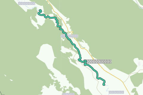
This kayak track is the fourth kayak track of the Khwae Noi River descent and part of the Khwae Noi River Kayak Project set up by Ayutthaya Kayaking Experience [AKE] aiming to paddle the full stretch of this river from the Vajiralongkorn Dam in Thong Pha Phum district until its confluence with the Mae Klong River at Kanchanaburi (Thailand).
The Khwae Noi, translated small tributary, was initially simply the River Kwae and a tributary of the Mae Klong River, which empties into the Gulf of Siam at Samut Songkhram. When Pierre Boulle’s novel "The Bridge on the River Kwai" written in 1952, turned into a well-known motion picture in 1957, confusion reigned all over. While in the film, the famous bridge was built over the "River Kwai", in reality it was not built over the Khwae River, but over the Mae Klong River in Tha Makham. People are inventive, so the Mae Klong River was shortened and the stretch north of Kanchanaburi was renamed the Khwae Yai; the Khwae River became the Khwae Noi. As thus geographical denominations were adapted following the movie. Stan Ridgeway would sing "Things are never quite the way they seem".
The Khwae Noi rises to the east of the Salween in the north-south spine of Bilauktaung range. Three small rivers, the Huay Song Kalia, the Maenam Ran Ti and the Maenam Bi Khi join to form the Khwae Noi close to Ban Ni The, south of the Three Pagoda pass in Sangkhla Buri district. From there the river flows south-east, receiving numerous small tributaries until it joins the Khwae Yai near Kanchanaburi to form the Mae Klong River.
The Khwae valley was a strategic route since ancient times. It was through the Three Pagoda Pass that the Burmese armies descended to attack the Siamese city of Ayutthaya. The Khwae valley offered a more easy passage than the mountains, and the river provided water to troops and combat animals.
Also the Japanese High Command in the 2nd World war was keen to open that route as their naval superiority in the Pacific had become unattainable after the Battle of Midway in June 1942. A Siam-Burma railway was seen as a vital alternative to supply the Japanese Army in Burma. The railway line, 415 kilometers long, followed the same route the British had surveyed in 1903: the line from Nong Pladuk passed through Kanchanaburi and crossed the Mae Klong river to follow the Khwae River to the Burmese border. From the Three Pagoda Pass it travelled northwest to link up with the British line to Rangoon at Thanbyuzayat on the Burmese coast. It is said that the first survey by the Japanese engineers predicted that it would take at least five years to finish this railway line, but the Japanese army forced the prisoners to complete it in only sixteen months. The lines joined on 17 October 1943 at Konkoita and the railway was operational on 25 December 1943. Every kilometer costs the lives of 38 allied soldiers, while the total human sacrifice was calculated at one life per used wooden sleeper for the track. After the war Thailand and Burma agreed to destroy the tracks from their common borders until 100 Km into each country (in Thailand until Nam Tok station in Tha Sao sub-district).
Information and photographs on the Death Railway are mainly from the two following sites: Australian War Memorial - http://www.awm.gov.au and Britain At War - http://www.britain-at-war.org.uk/WW2/Death_Railway.
This track brings you from Hin Tok to Wang Krachae. Point of interest on this route is the famous Hell Fire Pass. The tour will take 5-6 hours according to your level of physical fitness, the conditions of the water current, and your personal kayaking experience. Highlights are listed to give you a number of reference points on this tour itinerary. Do not initiate this tour without the necessary physical fitness and preparation.
Tips and Warnings
General - Stock up supplies of water (500 ml/hr), electrolyte beverages (3-4 bottles) and dry food (take a snack every 2 hours) as there is hardly opportunity to find a meal on this itinerary. Keep up mobile communications with somebody for emergency cases and do know where you are exactly at all times. Protect your equipment with waterproof bags and tie everything to the boat.
Water currents - The most important variable for making kayaking plans is water current. Rainy season will result in flooding and/or rapidly moving water. In this case not every kayak is suitable. For this track in the rainy season you will need a kayak suitable for wild water. This track is notorious for whirlpools during the rainy season. Use caution when the current is fast and wear a life jacket.
Clothing - Wear a good hat and loose-fitting clothing that dries quickly. Long pants and shirts with long sleeves may be useful and appropriate to protect you from the sun. The refracted sunlight from the water makes sunburn commonplace, so put on plenty of sun block on not covered parts of your body and wear sunglasses.
Who are we?
Ayutthaya Kayaking Experience [AKE] is a sportive subsidiary from Ayutthaya Historical Research. AKE’s objective is to promote kayaking tourism in Ayutthaya, by basically showing kayak presence on canals and rivers. Kayaking is the perfect outdoor recreation to explore the city island contours and its surroundings. We are local expatriates who have been living in Ayutthaya for many years and would like to share our kayak knowledge with other sportsmen. More information on AKE can be found at: http://aykaex.yolasite.com/
Disclaimer
Ayutthaya Historical Research or Ayutthaya Kayaking Experience will not be held liable for any loss or damage whatsoever for any suggestions made in relation to the site’s promotion of ecotourism. It is the responsibility of the user of the site to take the necessary precautions to avoid any physical injury, traffic incident, animal attack, theft, and damage to equipment. Any reliance on the site’s information is therefore strictly at your own risk. Read our full disclaimer at website www.ayutthaya-history.com.
©2010-2018 Ayutthaya Kayaking Experience.
All rights reserved.
Navegar ruta en...
![]() Aplicación RouteYou Abre
Aplicación RouteYou Abre
¿No quieres ver más este anuncio?
→ Mejorar ahora
![]()
Espere, se está preparando la navegación.
Ahora puede navegar. ¡Diviértete en el camino!
El procesamiento de la solicitud ha fracasado. Por favor, inténtelo de nuevo.
¿No quieres ver más este anuncio?
→ Mejorar ahora
![]()
Espere, se está preparando su descarga.
Su descarga esta lista. ¡Diviértete en el camino!
El procesamiento de la solicitud ha fracasado. Por favor, inténtelo de nuevo.
¿No quieres ver más este anuncio?
→ Mejorar ahora
![]()
Espere, se está preparando su impresión.
Su impresión está lista para descargarse. ¡Diviértete en el camino!
El procesamiento de la solicitud ha fracasado. Por favor, inténtelo de nuevo.
¿No quieres ver más este anuncio?
→ Mejorar ahora
![]()
Espere, se está preparando su descarga.
Su descarga esta lista. ¡Diviértete en el camino!
El procesamiento de la solicitud ha fracasado. Por favor, inténtelo de nuevo.
<iframe src="https://plugin.routeyou.com/routeviewer/free/?language=es&params.route.id=295727&params.language=en" width="100%" height="600" frameborder="0" allowfullscreen></iframe>
<a href="https://www.routeyou.com/en-th/route/view/295727/canoe-kayak-route/4-hintok-wang-krachae-kayak-track?utm_source=embed&utm_medium=article&utm_campaign=routeshare" title="4. Hintok - Wang Krachae Kayak Track - RouteYou" target="_blank"><img src="https://image.routeyou.com/embed/route/960x670/295727-en@2x.png" width="960" height="670" alt="4. Hintok - Wang Krachae Kayak Track"></a>
Comentarios adicionales:
Pruebe esta funcionalidad gratis con una suscripción de prueba RouteYou Plus.
Si ya dispone de dicha cuenta, conectarse ahora.
Pruebe esta funcionalidad gratis con una suscripción de prueba RouteYou Premium.
© 2006-2024 RouteYou - www.routeyou.com