125 vues | Publique
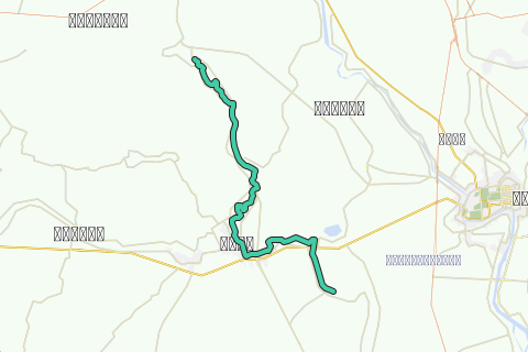
This kayak track is the fiftth kayak track of the Chao Phraya Noi River descent and part of the Chao Phraya Noi River Kayak Project set up by Ayutthaya kayaking Experience [AKE] aiming to paddle the full stretch of this river from north of the Chaya Phraya Dam in Chainat district until its confluence with the Chao Phraya River at Bang Sai (Thailand).
The Maenam Noi or Chao Phraya Noi (or small Chao Phraya) is one of the three tributaries of the Chao Phraya. The latter is formed by the confluence of four rivers at Nakhon Sawan being the Ping, the Nan, the Wang and the Yom. The Chao Phraya gives birth to three children of its own: the Tha Chin or Suphan River, the Noi River and further downstream the Lopburi River; starting in fact a delta at Chainat. The Noi River branches off from the Chao Phraya River about 5 Km south of Chai Nat. It is one of the former courses of the Chao Phraya itself.
The Chao Phraya initially flowed west of its present course beginning just below Chai Nat and running to Ang Thong via Sankha Buri, Bang Rachan and Pho Thong. The river must then have breached its west bank near Ang Thong because in its route it ran south-west from Intha Pramun via Wiset Chai Chan, Phak Hai, and Sena, and entered its present-day channel at Bang Sai. After some time, the river bed of the Chao Phraya over Sankha Buri appears to have silted up and the river shifted to the east. The Chao Phraya broke its east bank near Chainat, flowing nearly north-east for 12 kilometers before turning south, approximating the Chao Phraya’s present course from Chainat to Ang Thong. In 1857 the Chao Phraya River took a new course from Ang Thong to Ayutthaya, due to man-made channel works. The old river bed from Chainat over Ang Thong and Sena to Bang Sai became as thus known as the Chao Phraya Noi. The latter re-enters the Maenam at Wat Bang Sai.
This track brings you from Talan in Phak Hai district to Bang Yi Tho in Sena district of Ayutthaya. The Noi River here runs along the borders or through Ban Yai, Tha Din Daeng and Kudi in Phak Hai district; Ban Krathum, Hua Wiang, Ban Pho, Ban Phaen, Mueang Sena and Bang Nom Kho in Sena district; Nam Tao and Phra Khao in Bang Ban district; Bang Yi Tho, Na Mai and Chang Lek in Bang Sai district; all districts of Ayutthaya Province. There was quite a bit of bird life along this track and we met wild monkeys living on the river bank in Bang Phaen. From Sena onwards we find limited activity of tugboats and barges. The first shipyard building barges was found in Bang Nom Kho north of Sena and a second wharf was situated south of Sena. On this track were two confluences with canals coming straight (no water barriers) from the Chao Phraya River, being the Bang Luang canal with confluence at Hua Wiang and the Bang Ban Canal with confluence at Wat Sikuk.
The tour will take 6-7 hours of paddling according to your level of physical fitness, the conditions of the water current, and your personal kayaking experience. Highlights are listed to give you a number of reference points on this tour itinerary. Do not initiate this tour without the necessary physical fitness and preparation.
Tips and Warnings
General - Stock up supplies of water (500 ml/hr), electrolyte beverages (3-4 bottles) and dry food (take a snack every 2 hours) as there is hardly opportunity to find a meal on this itinerary. Keep up mobile communications with somebody for emergency cases and do know where you are exactly at all times. Protect your equipment with waterproof bags and tie everything to the boat.
Water currents - The most important variable for making kayaking plans is water current. Rainy season will result in flooding and/or rapidly moving water. In this case not every kayak is suitable. For this track in the rainy season you will need a kayak suitable for wild water. This track is notorious for whirlpools during the rainy season. Use caution when the current is fast and wear a life jacket.
Clothing - Wear a good hat and loose-fitting clothing that dries quickly. Long pants and shirts with long sleeves may be useful and appropriate to protect you from the sun. The refracted sunlight from the water makes sunburn commonplace, so put on plenty of sun block on not covered parts of your body and wear sunglasses.
Who are we?
Ayutthaya Kayaking Experience [AKE] is a sportive subsidiary from Ayutthaya Historical Research. AKE’s objective is to promote kayaking tourism in Ayutthaya, by basically showing kayak presence on canals and rivers. Kayaking is the perfect outdoor recreation to explore the city island contours and its surroundings. We are local expatriates who have been living in Ayutthaya for many years and would like to share our kayak knowledge with other sportsmen. More information on AKE can be found at: http://aykaex.yolasite.com/
Disclaimer
Ayutthaya Historical Research or Ayutthaya Kayaking Experience will not be held liable for any loss or damage whatsoever for any suggestions made in relation to the site’s promotion of ecotourism. It is the responsibility of the user of the site to take the necessary precautions to avoid any physical injury, traffic incident, animal attack, theft, and damage to equipment. Any reliance on the site’s information is therefore strictly at your own risk. Read our full disclaimer at website www.ayutthaya-history.com.
©2010-2011 Ayutthaya Kayaking Experience
All rights reserved.
Parcourir l'itinéraire dans...
![]() Application RouteYou Ouvrez
Application RouteYou Ouvrez
Plus voir cette annonce?
→ Améliorez maintenant
![]()
Veuillez patienter, la navigation est en cours de préparation.
Vous pouvez maintenant naviguer. Amusez-vous en route!
Le traitement de votre requête a échoué. S'il vous plaît réessayez.
Plus voir cette annonce?
→ Améliorez maintenant
![]()
Veuillez patienter, votre téléchargement est en cours de préparation.
Votre téléchargement est prêt. Amusez-vous en route!
Le traitement de votre requête a échoué. S'il vous plaît réessayez.
Plus voir cette annonce?
→ Améliorez maintenant
![]()
Veuillez patienter, votre impression est en cours de préparation.
Votre impression est prête à être téléchargée. Amusez-vous en route!
Le traitement de votre requête a échoué. S'il vous plaît réessayez.
Plus voir cette annonce?
→ Améliorez maintenant
![]()
Veuillez patienter, votre téléchargement est en cours de préparation.
Votre téléchargement est prêt. Amusez-vous en route!
Le traitement de votre requête a échoué. S'il vous plaît réessayez.
<iframe src="https://plugin.routeyou.com/routeviewer/free/?language=fr&params.route.id=330044&params.language=en" width="100%" height="600" frameborder="0" allowfullscreen></iframe>
<a href="https://www.routeyou.com/en-th/route/view/330044/canoe-kayak-route/5-talan-bang-yi-tho-kayak-track?utm_source=embed&utm_medium=article&utm_campaign=routeshare" title="5. Talan - Bang Yi Tho Kayak Track - RouteYou" target="_blank"><img src="https://image.routeyou.com/embed/route/960x670/330044-en@2x.png" width="960" height="670" alt="5. Talan - Bang Yi Tho Kayak Track"></a>
Commentaires supplémentaires:
Essayez cette fonctionnalité gratuitement avec un abonnement d'essai RouteYou Plus.
Si vous avez déjà un tel compte, connectez-vous maintenant.
Essayez cette fonctionnalité gratuitement avec un abonnement d'essai RouteYou Premium.
© 2006-2024 RouteYou - www.routeyou.com