Risorsa: Responsible?
Diritti d'autore: Creative Commons 3.0
963 visite | Pubblica
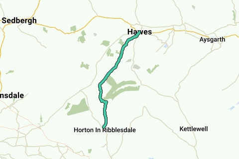
The Pennine Way is a National Trail in England, with a small section in Scotland. The trail runs 267 miles (429 km) from Edale, in the northern Derbyshire Peak District, north through the Yorkshire Dales and the Northumberland National Park and ends at Kirk Yetholm, just inside the Scottish border. The path runs along the Pennine hills, sometimes described as the "backbone of England". Although not the United Kingdom's longest National Trail (this distinction belongs to the 630-mile (1,014 km) long South West Coast Path), it is according to the Ramblers' Association "one of Britain's best known and toughest".
More info on Wikipedia Wikipedia and Openstreetmap.
Inspired by OSM.
Roads 
Appropriateness as Walking route: 

Paved:  (75.87% - 17 km unpaved)
Traffic load:  (low traffic)
Noise pollution: 
Landscape Characteristics
Nature landscape: 
Urbanized area: 
Near water: 
Dominant direction( ) :41%
  :43%
:43%
Above analysis can contain errors because of missing or incomplete information in our database. Help us improve the score of this route by answering the questions on following link.
Naviga nel percorso in...
![]() App RouteYou Aprire
App RouteYou Aprire
Vuoi smettere di vedere questo annuncio?
→ Upgrade ora
![]()
Attendi, la navigazione è in preparazione.
Ora puoi navigare. Buon divertimento in viaggio!
Elaborazione della richiesta non è riuscita. Si prega di riprovare.
Vuoi smettere di vedere questo annuncio?
→ Upgrade ora
![]()
Attendi, il tuo download è in preparazione.
Il tuo download è pronto. Buon divertimento in viaggio!
Elaborazione della richiesta non è riuscita. Si prega di riprovare.
Vuoi smettere di vedere questo annuncio?
→ Upgrade ora
![]()
Attendi, la tua stampa è in preparazione.
La tua stampa è pronta per il download. Buon divertimento in viaggio!
Elaborazione della richiesta non è riuscita. Si prega di riprovare.
Vuoi smettere di vedere questo annuncio?
→ Upgrade ora
![]()
Attendi, il tuo download è in preparazione.
Il tuo download è pronto. Buon divertimento in viaggio!
Elaborazione della richiesta non è riuscita. Si prega di riprovare.
<iframe src="https://plugin.routeyou.com/routeviewer/free/?language=it&params.route.id=4386994&params.language=en" width="100%" height="600" frameborder="0" allowfullscreen></iframe>
<a href="https://www.routeyou.com/en-gb/route/view/4386994/walking-route/pennine-way-horton-in-ribblesdale-to-hawes?utm_source=embed&utm_medium=article&utm_campaign=routeshare" title="Pennine Way (Horton in Ribblesdale to Hawes) - RouteYou" target="_blank"><img src="https://image.routeyou.com/embed/route/960x670/4386994-en@2x.png" width="960" height="670" alt="Pennine Way (Horton in Ribblesdale to Hawes)"></a>
Altri commenti:
Prova questa funzionalità gratuitamente con un abbonamento di prova RouteYou Plus.
Se hai già un tale account, accedi ora.
Prova questa funzionalità gratuitamente con un abbonamento di prova RouteYou Premium.
© 2006-2024 RouteYou - www.routeyou.com