Takket være vores partner Pasar vzw får du gratis adgang til denne rute – OG du kan lære RouteYou PLUS at kende.
Opdag alle fordelene12414 gange set | Offentlig | Fransk • Nederlandsk • Tysk
 Azure
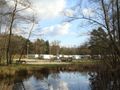
AzureMeet at the parking lot of Flemish Nature Reserve De Teut, at the end of the Donderslagseweg in Zonhoven. Depart in the extension of the Donderslagseweg and follow the signs of an orange, green, blue and red walking route. You immediately step through the heath, walk over the Teutheuvel and stroll further to a large pond. The green path turns left here. You walk straight ahead between two ponds. Bending along the path to the right and walk under the old railway bridge. Now there is a paved cycle path over it. The blue path turns right here. That's for later. Now you go straight ahead and follow the orange and red path. A hundred meters further you take a narrow path on the left and go into the forest. You come to a narrow asphalt road and follow it straight ahead. At the T-junction, turn left and continue to follow the orange and red signs. You walk past a white half-timbered house and take the forest path on the right a little further on. Immediately afterwards, the orange route turns right. You will continue to follow the red triangles and from now on also the yellow hexagons. You walk past camping Holsteenbron and continue on a wide gravel road through forest and heathland until you reach a clearing with a large grassy plain. Here a number of signposted trails come together, 2 1 V not only for hikers, but also for riders and mountain bikers. The red path goes straight ahead here. From now on, follow the yellow hexagons. You make a hairpin turn to the right and step 200 m further, on the left, onto a narrow, rising forest road. It takes you back to the heath and birch trees.
You now walk for a while along the grassy plain that you could already see from below. If you don't like to walk along that grassy plain, you can follow a GR path: that will come back later on the yellow path. In both cases, you will eventually pass the closure of a former military domain. Fortunately, you can turn away from that pretty quickly. You cross the rails of an overgrown (former, military) railway and walk along it for a while. Then you go into the forest. The signage leads you through the forest and via a narrow path to a wide concrete road, which probably used to have a military function. A number of roads come together here. Cross this road and continue walking diagonally to the left, on a wide dirt road. Now you walk a long way through the Molenheide, with beautiful views. You step along a grassy plain with a street behind it and then go back into the heathland. Keep following the yellow hexagons until you reach a barrier. Step past it and you're just next to a crossroads of asphalt roads. Turn right for a moment and then left until you reach the hollow stones. The signposted hiking trails turn right here. Because we want to keep walking on the same roads to a minimum, you go straight to the hollow stone in the background. On the information board you can read that this was once a polishing stone. The terrace of café-restaurant Holsteenhoeve can be reached directly from here. But you can also take the narrow forest path on the left to the asphalt road. Follow it to the right, past the Holsteenhoeve, and at the intersection step straight on the dirt road. Ignore the path on the right, which you turned into at the beginning of the walk, and continue to the old railway bridge. Here you take the forest road on the left. On the right fens and on the left 4 3 the new Keureroute, 'a poetic project'. Leave a side road on the right and continue walking until you reach the St. Rochus Chapel. Walk straight ahead at the crossroads and continue on a narrow asphalt path between meadows and fields, over the Mierenbeek to a wider asphalt road. Follow it to the right. At the first intersection, go straight ahead and continue to follow Terlinden and at the next fork keep left. You cross the Grote Molenbeek and continue walking through the agricultural landscape. At the next two forks, keep to the right. On a wall picture at a farm you can read that you are in the Bontestraat. Where it turns left, follow the asphalt road straight ahead. A little further on, this road makes a right-angled turn to the left. Here you walk straight ahead and continue walking on a grassy path. First between two meadows, then you go into the forest. Where the path comes to a T, turn left and a little further right and continue along a meadow. Then you walk along a timber wall to the Marselaersmolen (18th century according to a sign of VTB-VAB, built before 1312 according to the Belgian Mill Database). It is certain that the mill wheel was removed in 1960 and that the mill has been protected as a monument since 1983. Here you turn right. Cross the Grote Molenbeek and at the fork of field roads, go straight ahead for the grass path, which is forbidden for riders, but with a clear bicycle track, because here the Molenbeek cycle route meets you! You cross a field road and continue walking along a rest bench and a pollard willow to a traffic road. Even 3 2 a typical Wijer landscape (wetlands). Then it goes into the forest. Follow the blue windows and continue on a field road until you reach the heathland again. After a few bends you come to an asphalt road. Follow it to the right and cross the old railway bed. On the right you will find a beautiful picnic area. After 50 m you step on the right again onto a narrow sandy path. The blue diamonds show you the way to the starting point without any problems.
Har du lagt mærke til noget på denne rute?Tilføj et problem
Naviger ruten med...
![]() RouteYou app Åbn
RouteYou app Åbn
![]()
Et øjeblik, din udskrift forberedes.
Din udskrift er klar til download. God fornøjelse på farten!
Behandlingen af anmodningen mislykkedes. Prøv venligst igen.
<iframe src="https://plugin.routeyou.com/routeviewer/free/?language=da&params.route.id=5367072&params.language=en" width="100%" height="600" frameborder="0" allowfullscreen></iframe>
<p><a class="routeYou_embed" href="https://app.routeyou.com/en-be/route/view/5367072?utm_source=embed&utm_medium=article&utm_campaign=routeshare&navigation=external" title="In the Zonhovense Teut - RouteYou" target="_blank"><img src="https://image.routeyou.com/embed/route/960x670/5367072-en@2x.png" style="width: 100%; height: auto;" alt="In the Zonhovense Teut"></a></p>
Yderligere feedback:
Du skal mindst have en RouteYou PREMIUM-konto for at kunne bruge denne funktion.
Prøv nu 1 måned gratis og oplev forskellen! Vi beder ikke om betalingsoplysninger, og det stopper automatisk efter din prøveperiode på en måned.
© 2006-2026 RouteYou - www.routeyou.com