Grazie al nostro partner Pasar vzw, puoi accedere gratuitamente a questo itinerario e conoscere RouteYou PLUS.
Scopri tutti i vantaggi Azure
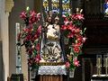
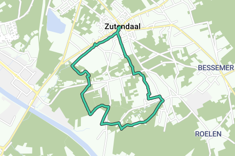
AzureAppointment at the Church of Our Lady of Zutendaal (V). Leave, with your back to the church, turn right into the Daalstraat, after 100 meters turn left and then immediately right and at the fork turn right into the Heibergstraat. If you park at the church, you have to submit a parking ticket, at the junction here there is a free parking. On the right you see an old gatehouse and behind it the presbytery 1. The asphalt track becomes a forest road and brings you back on the asphalt after half a kilometer. Turn right and then left into Muggenbergstraat. After 750 meters you enter the forest and another 40 meters further the asphalt stops. Here turn left on the first narrow forest path up and after 200 meters at an intersection turn left. Soon you have grassland on the right. • Turn past the meadow (in the summer months a corn field) to the right and continue walking between forest and meadow. The dirt road turns to the right and then to the left. Cross successively a wider dirt road, a small stream and soon also the asphalt track. Continue 50 meters at the T-junction to the right (arrow with blue diamond). The forest road connects to an asphalt road. Continue walking diagonally to the left on the asphalt (blue window). The asphalt becomes paved dirt road. Ignore the exit on the right and at the fork with sofa choose on the right. Ignore another right turn and turn left at the T-junction. Leave an exit on the left and walk straight ahead (blue window). Turn right on the asphalt track. After 100 meters you have a covered picnic area 2 on the left. Leave the asphalt here and take the wide field road on the right. • Turn left at the T-junction, cross the asphalt track and walk into the Schansstraat. After 300 meters, take the exit on the right (including sign with blue diamond). After 150 meters you will come to a T-junction 3 . Turn left here, and stay 1.3 kilometers on the wide dirt road. At the Hoogkantstraat you turn left and you come to a square with a statue in honor of the writer Jeroen Brouwers 4, well-known resident of Zutendaal. Walk past the statue to the left and after 50 meters turn diagonally right into Bruidsstraat. After 100 meters, turn left on a narrower asphalt track and where the asphalt stops, turn right on a path between meadow and field. The field road takes you back to an asphalt track after 750 meters. Walk to the left and turn right a little further into Blookbergstraat. After 250 meters you are at the signs of Lieteberg. Lieteberg is one of the six gateways to the Hoge Kempen National Park. 100 meters to the left you have the entrance to the visitor's entrance, the barefoot path, the insect museum and the cafeteria 5 . Continue walking straight on in the Blookbergstraat. Soon you will come to a large information board and the parking of Lieteberg. Walk to the left of the car park straight ahead between the sports fields and a little further along the cemetery still in the Blookbergstraat. Turn right into Nachtegalenstraat and then left into Vonderstraat. Just to the right and you are back at the church
Hai notato qualcosa su questo itinerario?Aggiungere un problema
Naviga nel percorso in...
![]() App RouteYou Aprire
App RouteYou Aprire
![]()
Attendi, la tua stampa è in preparazione.
La tua stampa è pronta per il download. Buon divertimento in viaggio!
Elaborazione della richiesta non è riuscita. Si prega di riprovare.
<iframe src="https://plugin.routeyou.com/routeviewer/free/?language=it&params.route.id=5367084&params.language=en" width="100%" height="600" frameborder="0" allowfullscreen></iframe>
<p><a class="routeYou_embed" href="https://app.routeyou.com/en-be/route/view/5367084?utm_source=embed&utm_medium=article&utm_campaign=routeshare&navigation=external" title="To Lieteberg in Zutendaal - RouteYou" target="_blank"><img src="https://image.routeyou.com/embed/route/960x670/5367084-en@2x.png" style="width: 100%; height: auto;" alt="To Lieteberg in Zutendaal"></a></p>
Altri commenti:
Questa funzionalità è disponibile esclusivamente per gli abbonati a RouteYou PREMIUM.
Prova 1 mese gratis e scopri la differenza! Non prendiamo alcun dettaglio di pagamento e la tua prova termina automaticamente dopo un mese.
© 2006-2025 RouteYou - www.routeyou.com