12518 vues | Public | allemand • français • néerlandais
 Azure
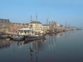
AzureThe river IJssel has existed for many thousands of years. After our era, the IJssel received water from the Rhine. Until about the year 1300, the IJssel was a 'Braiding' river. The course of the river changed and flowed along several river arms. After the St. Elisabeth flood in 1421 and the subsequent floods, the Rhine was able to drain its water more quickly through the Waal to the North Sea. As a result, the IJssel had less water to process. The river became difficult to navigate and became a shallow river with many 'dead' river arms. The Zalkerbos is an example of a dead river arm that has grown into a nature reserve. Due to the strengthening of the banks and the construction of dikes, the course of the river has become more stuck.
The landscape between Kampen and Zwolle is still unspoilt river landscape in many places. High water caused many dike breaches, which can still be found as a gully in many places in the river landscape. The last dike breach was at Zalk in 1962. The floodplains often flood and many special plant and animal species benefit from this. (Pollard) willows are also part of the river landscape, because it is one of the few tree species that can withstand being in the water for a long time. The floodplains are also important for birds. The eel barge, grebe, grotto, lapwing and small karekite are birds that breed on the floodplains in the summer. In winter, wintering birds such as swans and (col) geese are on the IJssel floodplains.
Vous avez remarqué quelque chose sur cet itinéraire ?Ajouter rapport
Parcourir l'itinéraire dans...
![]() Application RouteYou Ouvrez
Application RouteYou Ouvrez
Vous ne voulez plus voir cette publicité ?
→ Actualiser maintenant
![]()
Veuillez patienter, la navigation est en cours de préparation.
Vous pouvez maintenant naviguer. Bonne route !
Le traitement de la demande a échoué. Veuillez réessayer.
Vous ne voulez plus voir cette publicité ?
→ Actualiser maintenant
![]()
Veuillez patienter, votre téléchargement est en cours de préparation.
Votre téléchargement est prêt. Bonne route !
Le traitement de la demande a échoué. Veuillez réessayer.
Vous ne voulez plus voir cette publicité ?
→ Actualiser maintenant
![]()
Veuillez patienter, votre impression est en cours de préparation.
Votre impression est prête à être téléchargée. Bonne route !
Le traitement de la demande a échoué. Veuillez réessayer.
<iframe src="https://plugin.routeyou.com/routeviewer/free/?language=fr&params.route.id=40111&params.language=en" width="100%" height="600" frameborder="0" allowfullscreen></iframe>
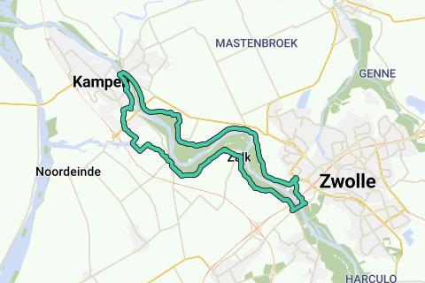
<p><a class="routeYou_embed" href="https://app.routeyou.com/en-nl/route/view/40111?utm_source=embed&utm_medium=article&utm_campaign=routeshare&navigation=external" title="IJsseldeltaroute - RouteYou" target="_blank"><img src="https://image.routeyou.com/embed/route/960x670/40111-en@2x.png" style="width: 100%; height: auto;" alt="IJsseldeltaroute"></a></p>
Commentaires supplémentaires :
Cette fonctionnalité est exclusivement disponible pour les abonnés RouteYou PREMIUM.
Essayez 1 mois gratuit maintenant et découvrez la différence ! Nous n'exigeons aucune donnée de paiement et le service s'arrête automatiquement après votre période d'essai d'un mois.
© 2006-2025 RouteYou - www.routeyou.com