73 Aufrufe | Öffentlich | Deutsch • Dänisch • Französisch • Italienisch • Niederländisch • Spanisch
The Grensdijkjespad is a long-distance walk of 86 km, following the old border levees of various Brabant rivers.
The route runs from Sint-Oedenrode to Breda. There is a connection to the Airborne Path, and there is an additional approach route of 23 km from Eindhoven station to the starting point in Sint-Oedenrode.
The name "Grensdijkjespad" comes from the various border levees that the route runs over. These levees were intended to guide the overflowing rivers like the Maas, Aa, Dommel, and Donge around populated areas. They also formed the boundary at various locations between the areas of the County of Holland and the Duchy of Brabant. The path runs largely through the region of the Meierij.
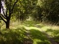
This area primarily consists of flat to gently rolling sandy soils in the Peel, the Kempen, and the catchment areas of the Aa and the Dommel.
In this area, we find many heath landscapes, marshes, peat areas, and forest landscapes.
The booklet Walking in Brabant on the Grensdijkjespad was published in 2008 by the KNBLO, on the occasion of their 100th anniversary. In 2024, the second-hand booklet was still available for purchase at bol.com. The path is wheelchair-friendly. At various locations, special alternative routes for wheelchair users are indicated in the booklet.
These digital routes may contain errors, as they are old routes. Therefore, it will be necessary to check on-site for each route whether it is still passable that way, or if another path is now better or more pleasant to walk.
Ist Ihnen auf dieser Route etwas aufgefallen?Problem hinzufügen
Route navigieren in...
![]() RouteYou-App Öffnen
RouteYou-App Öffnen
Diese Werbung nicht mehr anzeigen?
→ Jetzt upgraden
![]()
Bitte warten Sie, die Navigation wird vorbereitet.
Sie können jetzt navigieren. Viel Routen-Spaß!
Bearbeitung Ihrer Anfrage ist fehlgeschlagen. Bitte versuchen Sie es erneut.
Diese Werbung nicht mehr anzeigen?
→ Jetzt upgraden
![]()
Bitte warten Sie, Ihr Download wird vorbereitet.
Ihr Download ist fertig. Viel Routen-Spaß!
Bearbeitung Ihrer Anfrage ist fehlgeschlagen. Bitte versuchen Sie es erneut.
Diese Werbung nicht mehr anzeigen?
→ Jetzt upgraden
![]()
Bitte warten Sie, Ihr Ausdruck wird vorbereitet.
Ihr Ausdruck ist bereit für den Download. Viel Routen-Spaß!
Bearbeitung Ihrer Anfrage ist fehlgeschlagen. Bitte versuchen Sie es erneut.
<iframe src="https://plugin.routeyou.com/routeviewer/free/?language=de&params.route.id=14082985&params.language=en" width="100%" height="600" frameborder="0" allowfullscreen></iframe>
<p><a class="routeYou_embed" href="https://app.routeyou.com/en-nl/route/view/14082985?utm_source=embed&utm_medium=article&utm_campaign=routeshare&navigation=external" title="Border Dike Path - RouteYou" target="_blank"><img src="https://image.routeyou.com/embed/route/960x670/14082985-en@2x.png" style="width: 100%; height: auto;" alt="Border Dike Path"></a></p>
Zusätzliches Feedback:
Diese Funktion ist ausschließlich für RouteYou PREMIUM-Abonnenten verfügbar.
Testen Sie 1 Monat kostenlos und entdecken Sie den Unterschied! Wir erfassen keine Zahlungsdaten und Ihre Testversion endet automatisch nach einem Monat.
© 2006-2026 RouteYou - www.routeyou.com