Fuente: Groenehartstocht
Since 1310, the year the Nicolaaskerk in IJsselstein was taken into use, the people of IJsselstein buried their deceased in the consecrated ground in and around the church building. Inside the church, the wealthy residents were laid to rest; the church floor still contains grave slabs that remind us of this. The less fortunate were buried around the church, in the cemetery. Even after the Reformation, when the church building came under Reformed control, it continued to be used as a burial site. Both Reformed or “Reformed,” as they were called then, and Roman Catholics were buried there.
After various hygienic and structural objections had arisen during the French period against burying in churches, King William I put a definitive end to it by Royal Decree on August 22, 1827. From January 1, 1829, burying in church buildings was prohibited, and each municipality was required to establish a general cemetery. This cemetery had to be at least 35 meters away from the urban area, enclosed, and large enough to accommodate five times the number of people buried each year. The city council managed to obtain a six-month postponement of the ban, but from July 1829, IJsselstein had to have a general cemetery as well. The Roman Catholics had their own cemetery with consecrated ground behind their hidden church on Havenstraat since 1822; however, this proved to be so difficult under the new law that they decided to bury their dead also in the newly established general cemetery, in a specially separated section.
At the beginning of 1829, the municipality purchased a large piece of land in the polder Neder-Oudland along the Eitersedijk, now Eiteren. This was located 300 meters outside the city and provided ample required space. Since building a wall proved to be very costly, the financially strained IJsselstein decided instead to dig a ditch around the cemetery. A chapel was to be built on the cemetery and a fence was to be placed. The total costs amounted to over 3500 guilders. The Roman Catholics wanted their own fence around their part of the cemetery, which the municipality allowed. However, they were not allowed to interfere with the appointment of the grave digger, which was a matter for the municipality! On July 3, 1829, Jan Beelo, who died at the age of 34, was the first to be buried in the new cemetery, in a “Roman poor grave.”
For a long time, the general cemetery in Eiteren met the need for grave space, but around 1865, that need gradually became greater than the available land.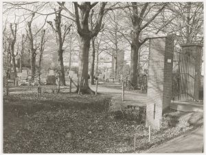 The problem was solved when, in 1865, the Roman Catholics took into use their own cemetery at Groenendijk; the Catholic graves were cleared, creating more space for graves for other denominations. This was also the reason for a new layout of the graves, where the old layout was maintained only for a number of old family graves of notable IJsselstein families like Van der Roest and Immink and for a few minister’s graves.
The growth of the municipality of IJsselstein also brought an increase in the number of funerals. By the middle of the last century, it became clear that the cemetery at Eiteren could no longer provide the necessary space for this. The same problem also occurred at the Roman Catholic cemetery, where the need was even greater. However, it would take until 1973 for the municipality, in consultation with the Roman Catholic parish council, to find a location for a new cemetery. This was at the Noord IJsseldijk, where suitable and sufficient land could be purchased. After some legal disputes with objectors, it was possible to start the actual construction and the building of a chapel in 1975. The site provided enough grave space for the next 25 years, and if necessary, it could still be expanded. On July 1, 1976, the general cemetery De Hoge Akker was officially opened. Since then, the general cemetery at Eiteren has only been used for occasional burials of old rights holders.
Fuente: RHCstreekarchief
 | | Pública | Alemán • Danés • Español • Francés • Italiano • Neerlandés

Selecciona una de las actividades más populares a continuación o afina tu búsqueda
Descubre las rutas más bonitas y populares de la zona, cuidadosamente agrupadas y seleccionadas.
Fuente: Groenehartstocht
Selecciona una de las categorías más populares a continuación o inspírate en nuestras selecciones
Descubre los lugares de interés más bonitos y populares de la zona, cuidadosamente agrupados y selecciondos.
Fuente: Groenehartstocht
Con RouteYou, es fácil crear tus propios mapas personalizados. Simplemente traza tu ruta, agrega puntos de ruta o nodos, agrega lugares de interés, lugares para comer y beber, y luego compártelo fácilmente con tu familia y amigos.
Planificador de rutas

<iframe src="https://plugin.routeyou.com/poiviewer/free/?language=es&params.poi.id=8194522&params.language=en" width="100%" height="600" frameborder="0" allowfullscreen></iframe>

Más de 11.800.000 rutas

Más de 15.000.000 usuarios

Más de 4.500.000 lugares de interés

Kerkstraat 108
9050 Gentbrugge, Bélgica
© 2006-2026 RouteYou - www.routeyou.com





