The Grensdijkjespad is a long-distance walk of 86 km, following the old border levees of various Brabant rivers.
The route runs from Sint-Oedenrode to Breda. There is a connection to the Airborne Path, and there is an additional approach route of 23 km from Eindhoven station to the starting point in Sint-Oedenrode.
The name "Grensdijkjespad" comes from the various border levees that the route runs over. These levees were intended to guide the overflowing rivers like the Maas, Aa, Dommel, and Donge around populated areas. They also formed the boundary at various locations between the areas of the County of Holland and the Duchy of Brabant. The path runs largely through the region of the Meierij.
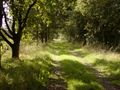
This area primarily consists of flat to gently rolling sandy soils in the Peel, the Kempen, and the catchment areas of the Aa and the Dommel.
In this area, we find many heath landscapes, marshes, peat areas, and forest landscapes.
The booklet Walking in Brabant on the Grensdijkjespad was published in 2008 by the KNBLO, on the occasion of their 100th anniversary. In 2024, the second-hand booklet was still available for purchase at bol.com. The path is wheelchair-friendly. At various locations, special alternative routes for wheelchair users are indicated in the booklet.
These digital routes may contain errors, as they are old routes. Therefore, it will be necessary to check on-site for each route whether it is still passable that way, or if another path is now better or more pleasant to walk.
¿Has notado algo en esta ruta?Añadir un problema
Navegar ruta en...
![]() Aplicación RouteYou Abre
Aplicación RouteYou Abre
¿No quieres ver más este anuncio?
→ Mejorar ahora
![]()
Espere, se está preparando la navegación.
Ahora puede navegar. ¡Diviértete en el camino!
El procesamiento de la solicitud ha fracasado. Por favor, inténtelo de nuevo.
¿No quieres ver más este anuncio?
→ Mejorar ahora
![]()
Espere, se está preparando su descarga.
Su descarga esta lista. ¡Diviértete en el camino!
El procesamiento de la solicitud ha fracasado. Por favor, inténtelo de nuevo.
¿No quieres ver más este anuncio?
→ Mejorar ahora
![]()
Espere, se está preparando su impresión.
Su impresión está lista para descargarse. ¡Diviértete en el camino!
El procesamiento de la solicitud ha fracasado. Por favor, inténtelo de nuevo.
<iframe src="https://plugin.routeyou.com/routeviewer/free/?language=es&params.route.id=14082985&params.language=en" width="100%" height="600" frameborder="0" allowfullscreen></iframe>
<p><a class="routeYou_embed" href="https://app.routeyou.com/en-nl/route/view/14082985?utm_source=embed&utm_medium=article&utm_campaign=routeshare&navigation=external" title="Border Dike Path - RouteYou" target="_blank"><img src="https://image.routeyou.com/embed/route/960x670/14082985-en@2x.png" style="width: 100%; height: auto;" alt="Border Dike Path"></a></p>
Comentarios adicionales:
Esta función está disponible únicamente para los suscriptores de RouteYou PREMIUM.
Pruébalo gratis durante 1 mes y descubre la diferencia. No pedimos datos de pago y se interrumpe automáticamente tras el periodo de prueba de un mes.
© 2006-2026 RouteYou - www.routeyou.com