1751 visitas | Pública | Alemán • Francés • Neerlandés
 Azure
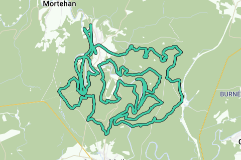
AzureLe Tombeau du Chevalier trail (58.76 km; D+ 2100m); southern version Herbeumont.
Based on http://www.festival-trail-semois.be/index.php's latest trail 'under construction' data, NGI topographic maps, own knowledge of the area and GPX records of the most important parts of the trail. The current trail eventually became not this one, but the north trail.
Following the Semois between Les Mauleûx and La Roche du Chat, I deviated from the path under construction and followed the forest path along the Semois to the south, after which the ascent begins north to Rue des Épioux along a forest road.
The flat distance is therefore 57km, the actual distance that takes into account the elevations to be covered is 58.76km; The altimeters to overcome are 2100m. See the first POI of this loop (Topographic Data The Knight's Tomb) for a detailed map and figures.
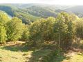
This trail is highly recommended for athletes who like to stay in the forest and who like an altitude difference of more than 2000m over more than 55km.
¿Has notado algo en esta ruta?Añadir un problema
Navegar ruta en...
![]() Aplicación RouteYou Abre
Aplicación RouteYou Abre
¿No quieres ver más este anuncio?
→ Mejorar ahora
![]()
Espere, se está preparando la navegación.
Ahora puede navegar. ¡Diviértete en el camino!
El procesamiento de la solicitud ha fracasado. Por favor, inténtelo de nuevo.
¿No quieres ver más este anuncio?
→ Mejorar ahora
![]()
Espere, se está preparando su descarga.
Su descarga esta lista. ¡Diviértete en el camino!
El procesamiento de la solicitud ha fracasado. Por favor, inténtelo de nuevo.
¿No quieres ver más este anuncio?
→ Mejorar ahora
![]()
Espere, se está preparando su impresión.
Su impresión está lista para descargarse. ¡Diviértete en el camino!
El procesamiento de la solicitud ha fracasado. Por favor, inténtelo de nuevo.
<iframe src="https://plugin.routeyou.com/routeviewer/free/?language=es&params.route.id=709108&params.language=en" width="100%" height="600" frameborder="0" allowfullscreen></iframe>
<p><a class="routeYou_embed" href="https://app.routeyou.com/en-be/route/view/709108?utm_source=embed&utm_medium=article&utm_campaign=routeshare&navigation=external" title="Trail Le Tombeau du Chevalier (58.8km), South version Herbeumont - RouteYou" target="_blank"><img src="https://image.routeyou.com/embed/route/960x670/709108-en@2x.png" style="width: 100%; height: auto;" alt="Trail Le Tombeau du Chevalier (58.8km), South version Herbeumont"></a></p>
Comentarios adicionales:
Esta función está disponible únicamente para los suscriptores de RouteYou PREMIUM.
Pruébalo gratis durante 1 mes y descubre la diferencia. No pedimos datos de pago y se interrumpe automáticamente tras el periodo de prueba de un mes.
© 2006-2025 RouteYou - www.routeyou.com