21080 visitas | Pública | Alemán • Francés • Neerlandés
 Azure
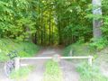
Azure50 km along mostly unpaved trails in the Sonian Forest, with as many altimeters as possible (H+750m).
The loop takes you 13 times past the ponds and onto the surrounding hills; Suitable for runners (trail), recreational cyclists and mountain bikers.
An extension of this trail can be found on this point of interest: https://www.routeyou.com/nl/location/view/47567201/zonienwoud-trail-marathon-vijvers-en-heuvels-ngi-foto-van-de-lus.nl
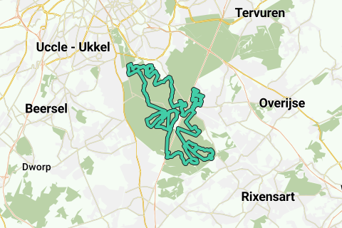
The starting point of the signaled GPS loop is at Groenendaal station (spacious car park) west of Hoeilaart, against Avenue Leopold-II on RO (south of the intersection of the Leonard tunnel with the E411-). You can get there both by public transport and by car.
The start and finish height is 98m.
Ge GPS is drawn clockwise: first the Pig Hole is to the north (King's Ponds); then follows the Sonian Forest via the Place de la Gare; First to the south, then to the west, north and east.
One of the particularities of this loop is that it serves all the regions of Belgium (http://nl.wikipedia.org/wiki/Gewesten_van_Belgi%C3%AB): the starting point is in the Flemish Region (Groenendaal), then we arrive in the Walloon Region (including La Hulpe), then back in the Flemish Region (St.-Genesius-Rode dan Groenendaal) to go to the Brussels-Capital Region (Uccle, Boitsfort), and finally back in the Flemish Region (Groenendaal).
The altimeters were made by crossing the hills to the ponds of the Sonian Forest. A path takes you downhill to each pond, and a next path leaves the pond uphill. This is repeated several times for different ponds, without using the same path twice.
In order, the following waters are made:
(1 and 2) King's Ponds (2x)
(3) Solvay Pond,
(4) Grey Mill Pond (and Solvay Pond),
(5) pond at the farm of the castle of La Hulpe (http://www.belgie-toerisme.be/informations/toeristische_attracties_la_hulpe__domein_van_solvay___kasteel_van_la_hulpe/nl/V/17431.html),
(6) Sint-Corneliuskerk pond (Groenendal Castle: http://www.flickr.com/photos/erfgoed/3248450268/),
(7 and 8) Goosefoot pond (2x),
(9) peeing on the Vuilbeek,
(10) horseshoe pond,
(11) ponds for drowned children;
(12) the Vuilbeek valley with two ponds, and
(13) Charles V Pond.
If this loop is too long, you can shorten it halfway to Groenendaal Castle: the Sint-Korneliuskapel pond and the Keizer Karelvijver are next to each other.
If you only want to do the upper half, take the same shortcut and start from a car park on the northern part (Ter Kameren bos, Boitsfort) or in the vicinity of Groenendaal Castle (Jan van Ruusbroec Bosmuseum bv).
Excellent trail near the Brussels region for the experienced runner. Some short stretches in natural areas are not allowed for mountain bikers, but for runners and pedestrians.
Several tourist sites are also located on this green route (see the POI): Solvay Castle and Park, Groenendaal Castle, the monument of the forest guards (1914-1918), the two Roman tumuli, the Arboretum Groenendaal, the Ruusbroec-Bosmuseum, ... It's also worth part of the family trip!
¿Has notado algo en esta ruta?Añadir un problema
Navegar ruta en...
![]() Aplicación RouteYou Abre
Aplicación RouteYou Abre
¿No quieres ver más este anuncio?
→ Mejorar ahora
![]()
Espere, se está preparando la navegación.
Ahora puede navegar. ¡Diviértete en el camino!
El procesamiento de la solicitud ha fracasado. Por favor, inténtelo de nuevo.
¿No quieres ver más este anuncio?
→ Mejorar ahora
![]()
Espere, se está preparando su descarga.
Su descarga esta lista. ¡Diviértete en el camino!
El procesamiento de la solicitud ha fracasado. Por favor, inténtelo de nuevo.
¿No quieres ver más este anuncio?
→ Mejorar ahora
![]()
Espere, se está preparando su impresión.
Su impresión está lista para descargarse. ¡Diviértete en el camino!
El procesamiento de la solicitud ha fracasado. Por favor, inténtelo de nuevo.
<iframe src="https://plugin.routeyou.com/routeviewer/free/?language=es&params.route.id=788450&params.language=en" width="100%" height="600" frameborder="0" allowfullscreen></iframe>
<p><a class="routeYou_embed" href="https://app.routeyou.com/en-be/route/view/788450?utm_source=embed&utm_medium=article&utm_campaign=routeshare&navigation=external" title="50K trail of the Sonian Forest, ponds and hills - RouteYou" target="_blank"><img src="https://image.routeyou.com/embed/route/960x670/788450-en@2x.png" style="width: 100%; height: auto;" alt="50K trail of the Sonian Forest, ponds and hills"></a></p>
Comentarios adicionales:
Esta función está disponible únicamente para los suscriptores de RouteYou PREMIUM.
Pruébalo gratis durante 1 mes y descubre la diferencia. No pedimos datos de pago y se interrumpe automáticamente tras el periodo de prueba de un mes.
© 2006-2025 RouteYou - www.routeyou.com