1778 visitas | Pública | Alemán • Francés • Italiano • Neerlandés
Go back in time along the trail of Bisse du Ro to the magnificent artificial lake of Tseuzier
Overview:
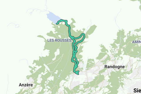
This hike leads you along the old Bisse du Ro to the Rawyl Dam and back in the direction of Bisse du Lens to Crans.
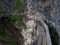
The Bisse du Ro is an old irrigation waterway build in the 15th century for bringing water don the mountain for irrigation of the lands. The traces of the ancient bisse are still good visible in the landscape. The bisse is hewn out of the rocks of the mountain and gives you extraordinary views over the valley, ravine and mountains. This is certainly not a trail for persons afraid of heights.
After we leave the Bisse du Ro we head to the Rawyl Dam where the big lake "Lac de Tseuzier" is situated. It collects the melting water of the snow and generates electricity. The dam was build between two mountain walls with an amazing rock structure.
When we head back to Crans, we take the lower path beneath the Bisse de Ro in the direction of Bisse de Lens. From this trail you get an other whole look of the valley and mountains. We end with a steap climb towards Crans-Sur-Sierre
Tips:
This hike is NOT advisable for persons afraid of heights!
Have respect for the infrastructure of Bisse du Ro
When arriving at the lake, you can do an additionally 1h trail around the lake
Story:
This hike takes you from Crans-Montana along the ancient Bisse du Ro, the old irrigation waterway that now is a trail hewn out of the rocks. After surviving this path we head further to Lac de Tseuzier with the Rawyl Dam. As an alternative you can go arround the lake (+1h!).
We do not return along the same path, we take the direction of Bisse de Lens wich takes you beneath the Bisse du Ro with a whole other view on the valley. The hike ends with a steep climb back to Plan-Mayens and Crans-Montana.
Don't know what happened with my GPS but the altitudes in the GPS log are approximately 500m incorrect. So here are the correct altitudes:
Start height: 1450m
Highest point: 1873m (tseuzier/tseuxier)
Lake: 1777m
Starting point:
Free parking at rue de bisse
Other starting point is at Plans-Mayens but on the city map it was not clear if there where any good parking spots there.
¿Has notado algo en esta ruta?Añadir un problema
Navegar ruta en...
![]() Aplicación RouteYou Abre
Aplicación RouteYou Abre
¿No quieres ver más este anuncio?
→ Mejorar ahora
![]()
Espere, se está preparando la navegación.
Ahora puede navegar. ¡Diviértete en el camino!
El procesamiento de la solicitud ha fracasado. Por favor, inténtelo de nuevo.
¿No quieres ver más este anuncio?
→ Mejorar ahora
![]()
Espere, se está preparando su descarga.
Su descarga esta lista. ¡Diviértete en el camino!
El procesamiento de la solicitud ha fracasado. Por favor, inténtelo de nuevo.
¿No quieres ver más este anuncio?
→ Mejorar ahora
![]()
Espere, se está preparando su impresión.
Su impresión está lista para descargarse. ¡Diviértete en el camino!
El procesamiento de la solicitud ha fracasado. Por favor, inténtelo de nuevo.
<iframe src="https://plugin.routeyou.com/routeviewer/free/?language=es&params.route.id=2260676&params.language=en" width="100%" height="600" frameborder="0" allowfullscreen></iframe>
<p><a class="routeYou_embed" href="https://app.routeyou.com/en-ch/route/view/2260676?utm_source=embed&utm_medium=article&utm_campaign=routeshare&navigation=external" title="Hiking along Bisse du Ro to Lac de Tseuzier - RouteYou" target="_blank"><img src="https://image.routeyou.com/embed/route/960x670/2260676-en@2x.png" style="width: 100%; height: auto;" alt="Hiking along Bisse du Ro to Lac de Tseuzier"></a></p>
Comentarios adicionales:
Esta función está disponible únicamente para los suscriptores de RouteYou PREMIUM.
Pruébalo gratis durante 1 mes y descubre la diferencia. No pedimos datos de pago y se interrumpe automáticamente tras el periodo de prueba de un mes.
© 2006-2025 RouteYou - www.routeyou.com